
North Central United States Faces Drier Than Normal Conditions Into Early June as El Nino Forces Moisture South With Drought Areas at Risk Through Sunday June 7
MINNEAPOLIS, Minnesota — Weekly forecast data is signaling more dry time on the horizon across the North Central United States as the calendar turns toward early June 2026, with El Nino forcing most moisture chances southward and leaving the northern half of the country in a worsening dry pattern through Sunday, June 7.
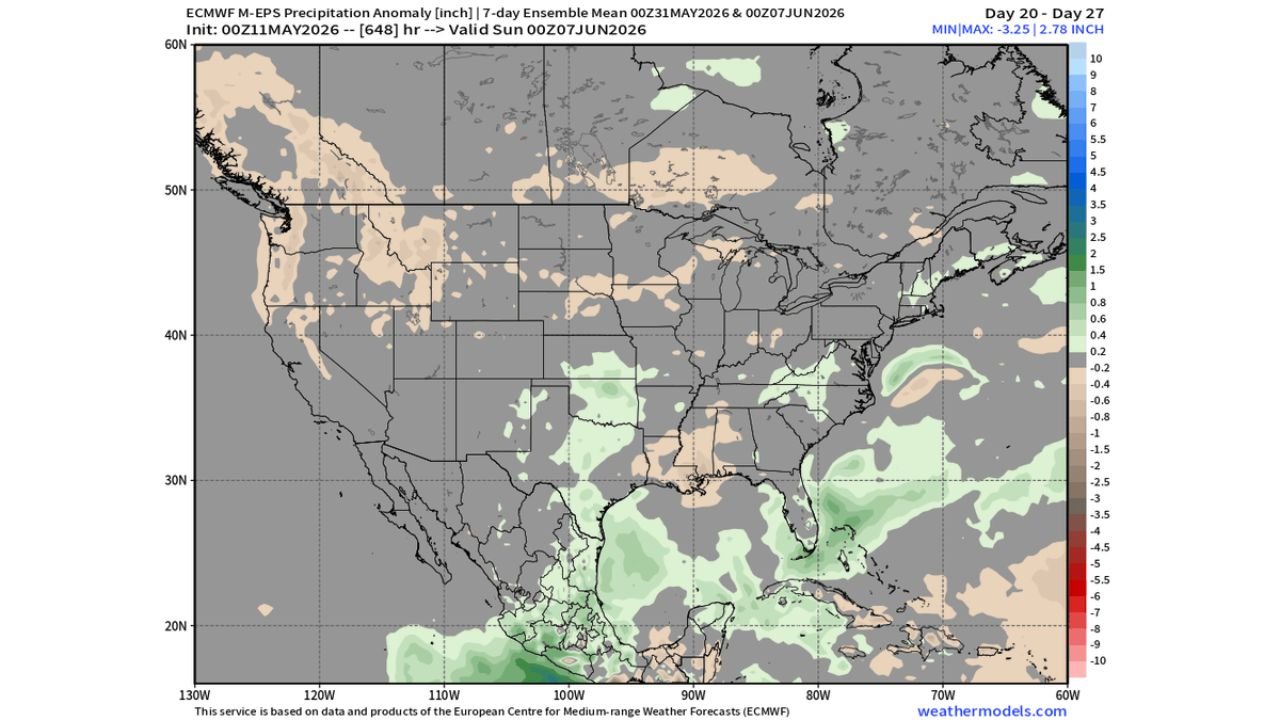
The precipitation anomaly forecast valid through Sunday, June 7 shows below normal to near zero rainfall across a large swath of the North Central United States, which is not a good sign for areas already dealing with drought conditions across the northern half of the country.
What the Precipitation Anomaly Map Shows
The 7-day ensemble precipitation anomaly forecast valid Sunday, May 31 through Sunday, June 7 reveals a clear split between the dry north and the wetter south:
- The North Central United States shows up in tan and brown on the anomaly map, indicating below normal to significantly below normal precipitation is expected across the northern half of the country through June 7. This dry signal extends across a broad zone covering the northern Plains, Midwest and into parts of the Great Lakes region.
- The minimum anomaly visible on the map reaches negative 3.25 inches in some locations, meaning certain areas of the North Central United States could end the June 7 period running more than 3 inches below normal rainfall totals for this stretch.
- The South and Gulf Coast states show up in green on the anomaly map, indicating above normal precipitation is expected across the southern half of the country through June 7 as El Nino forces moisture chances southward away from the northern states.
- The Northeast and parts of the Mid-Atlantic also show small areas of slightly above normal precipitation through June 7, continuing the pattern of moisture being redirected away from the North Central United States.
What El Nino Is Doing to the Pattern
El Nino is a warming of ocean temperatures in the Pacific that changes weather patterns across the entire country, and its influence on the summer pattern is clearly visible in this early June forecast:
- During El Nino summers, the jet stream and associated moisture tend to shift southward, meaning storms and rainfall that would normally track through the North Central United States are instead pushed into the South and Gulf Coast states.
- This is exactly what the May 31 through June 7 anomaly map is showing, with green above-normal precipitation signals across the South while the North Central United States sits in the dry tan and brown zone.
- For areas in the North Central United States already experiencing drought conditions, this El Nino-driven dry signal heading into early June means drought improvement is unlikely and conditions could worsen through the June 7 period.
Drought Concern for the Northern Half
The combination of an active dry stretch now and a continued below-normal precipitation signal into early June raises serious drought concerns across the northern half of the country:
- Areas across the North Central United States that were already running rainfall deficits heading into May will see those deficits grow larger through June 7 if this dry pattern verifies as forecast.
- Agricultural regions across the northern Plains and Midwest are particularly vulnerable to a multi-week dry stretch during late May and early June, when crops are in critical early growth stages and soil moisture is essential for healthy development.
- Water managers, farmers and residents across the North Central United States should begin monitoring drought indicators closely as the May 31 through June 7 dry period approaches.
Where Moisture Is Going Instead
While the North Central United States dries out, the South will see the opposite pattern through early June:
- Above normal precipitation signals are visible across the South and Gulf Coast on the anomaly map through June 7, with the maximum anomaly on the map reaching positive 2.78 inches in some southern locations.
- This southward moisture shift means Texas, Louisiana, Mississippi, Alabama and Florida are more likely to see above normal rainfall during the May 31 through June 7 period compared to the drought-prone North Central United States.
- The contrast between the dry north and wet south is a classic El Nino summer signature and is expected to persist beyond the June 7 forecast window based on current seasonal outlooks.
WaldronNews.com will continue tracking the developing dry pattern across the North Central United States and drought conditions and will provide updates as precipitation anomalies and El Nino influences develop through Sunday, June 7.