
Wisconsin Faces Multiple Tornado Warnings Overnight Including Dodgeville, Darlington, Spring Green and Platteville With Storms Moving Toward Janesville and Milwaukee Saturday May 16
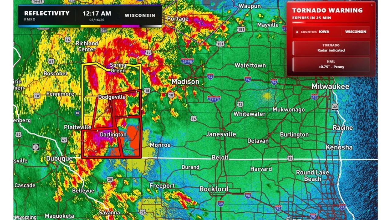
DODGEVILLE, Wisconsin – Multiple tornado warnings are active across southwestern Wisconsin right now at 12:17 AM on Saturday, May 16, with radar-indicated tornadoes and penny size hail under 0.75 inches confirmed in the warning area. The storm line is currently targeting Dodgeville, Darlington, Spring Green and Platteville and is expected to gradually weaken as it pushes toward Janesville and Milwaukee.
Active Tornado Warnings Right Now
A tornado warning covering counties in both Iowa and Wisconsin is active as of 12:17 AM Saturday, May 16 and expires in 25 minutes from time of issue. Key details from the active warning:
- Tornado is radar indicated, meaning rotation capable of producing a tornado has been detected on radar in southwestern Wisconsin as of 12:17 AM Saturday, May 16.
- Hail up to 0.75 inches in diameter, penny size, is also included in the active tornado warning across the affected counties.
- The warning covers counties in both Iowa and Wisconsin, with the most intense radar returns centered near Dodgeville and Darlington, Wisconsin.
Cities in the Immediate Path Right Now
The following communities in southwestern Wisconsin are under the immediate tornado warning threat as of 12:17 AM Saturday, May 16:
- Dodgeville and Spring Green, Wisconsin are directly inside the active tornado warning box and should be sheltering in the lowest interior room of a sturdy building right now.
- Darlington and Platteville, Wisconsin sit inside the second active warning box on radar and face the same immediate tornado and hail threat as of 12:17 AM.
- Richland Center, Boscobel and Fennimore, Wisconsin are within the broader severe storm corridor moving through southwestern Wisconsin overnight.
Where the Storm Line Is Headed
This storm line is expected to gradually weaken as it pushes northeast toward Janesville and Milwaukee, Wisconsin. While weakening is expected, residents along the storm track should not let their guard down until all warnings have expired for their area. If you are in Janesville or Milwaukee and going to bed tonight, keep weather alerts active on your phone in case conditions change overnight.
What To Do If You Are Under a Tornado Warning Right Now
If you are in Dodgeville, Darlington, Spring Green, Platteville or any surrounding community under an active tornado warning as of 12:17 AM Saturday, May 16, take shelter immediately. Go to the lowest floor of a sturdy building and get into an interior room away from all windows. Do not wait to see or hear the tornado before taking shelter. Radar-indicated rotation can produce a tornado with little to no visual warning at night.
WaldronNews.com will continue tracking these active tornado warnings across southwestern Wisconsin and will provide updates as storm movement toward Janesville and Milwaukee and any tornado touchdowns develop overnight Saturday, May 16.