
Nebraska and Iowa Face Level 4 Moderate Risk With Strong Tornadoes, 75 mph Wind Gusts and Very Large Hail Sunday May 17 Including Omaha, Sioux Falls and Hastings While Kansas and Oklahoma Face Dryline Threat With Large Hail and Tornadoes Late Afternoon
OMAHA, Nebraska – A Level 4 Moderate severe weather risk is now in place for Sunday, May 17 across Nebraska and Iowa, where a volatile atmospheric setup is expected to produce strong tornadoes, very large hail and wind gusts of 75 mph or higher during the afternoon and evening hours. Omaha, Sioux Falls and Hastings sit at the center of the greatest tornado threat zone, with forecasters expressing increasing confidence in a significant severe weather outbreak.
The Two Distinct Threat Zones Sunday May 17
Sunday, May 17 features two separate severe weather corridors that residents across multiple states need to understand:
- The Greatest Tornado Threat zone covers Omaha, Lexington and surrounding Nebraska communities, where a volatile warm front and triple-point setup during the afternoon and evening hours will favor rotating supercells capable of producing strong tornadoes, very large hail and wind gusts of 75 mph or higher as storms grow rapidly upscale. This zone carries a Level 4 Moderate risk.
- The Conditional Dryline Threat zone extends south through Lincoln, Wichita, Kansas City, Oklahoma City and Fort Smith, where large to very large hail is the primary concern if storms fire along the dryline during the late afternoon and early evening hours. A few tornadoes are also possible in this southern zone Sunday.
Risk Levels Across the Full Outbreak Zone
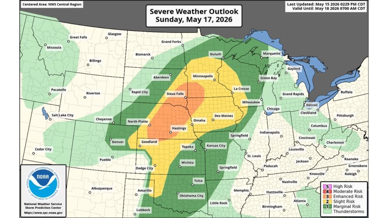
The official severe weather outlook valid through Monday morning, May 18 at 7:00 AM CDT shows four distinct risk categories:
- Level 4 out of 5 Moderate Risk covers the core tornado threat corridor centered on Sioux Falls, Omaha and Hastings, representing the highest risk designation currently in place and indicating widespread severe weather is expected Sunday.
- Level 3 out of 5 Enhanced Risk surrounds the Moderate zone and covers a broader area including North Platte, Topeka and Des Moines, where all severe hazards including tornadoes remain likely Sunday afternoon and evening.
- Level 2 out of 5 Slight Risk extends the threat into Minneapolis, Milwaukee, Kansas City, Wichita, Dodge City and Goodland, where isolated severe storms are possible Sunday.
- Level 1 out of 5 Marginal Risk covers the outermost zone reaching Duluth, Green Bay, Chicago, Springfield, Tulsa, Oklahoma City, Amarillo, Lubbock, Memphis and Little Rock, where a few storms could turn severe Sunday.
Why Omaha and Hastings Face the Greatest Tornado Danger
The area around Omaha, Lexington and Hastings, Nebraska is where forecasters see the most volatile atmospheric setup coming together Sunday afternoon and evening. A warm front and triple-point pattern, where multiple weather boundaries intersect, will provide enhanced spin in the lower atmosphere that rotating supercells can tap into for tornado production. Very large hail and strong tornadoes are both likely in this zone Sunday, with 75 mph or higher wind gusts also possible as storms grow upscale quickly.
Cities Facing the Most Dangerous Conditions Sunday
Communities inside and near the Level 4 Moderate and Level 3 Enhanced zones face the greatest risk this Sunday, May 17:
- Omaha and Hastings, Nebraska sit squarely inside the greatest tornado threat zone and face strong tornadoes, very large hail and 75 mph or higher wind gusts Sunday afternoon and evening.
- Sioux Falls, South Dakota is within the Moderate risk corridor and should prepare for all severe hazards including tornadoes through Sunday evening.
- Lexington, Nebraska sits inside the greatest tornado threat zone with forecasters highlighting this area as particularly volatile Sunday afternoon.
- North Platte, Nebraska and Topeka, Kansas fall within the Enhanced risk zone and face a real tornado and large hail threat Sunday.
- Des Moines, Iowa is within the Enhanced risk zone and should monitor conditions closely all day Sunday, May 17.
- Kansas City and Wichita, Kansas fall within the Slight risk zone but could still see isolated severe storms including large hail and a tornado Sunday afternoon and evening.
The Dryline Threat for Kansas and Oklahoma Sunday
Further south along the dryline, Lincoln, Wichita, Oklahoma City, Fort Smith and surrounding communities face a conditional threat Sunday afternoon. If storms fire along this boundary during the late afternoon and early evening, large to very large hail is the primary concern, though a few tornadoes will also be possible. This threat is more conditional than the northern zone but should not be dismissed.
What 75 mph Wind Gusts Mean for Your Property
Wind gusts of 75 mph or higher are capable of snapping trees at the trunk, downing power lines, destroying fences, flipping vehicles and causing significant structural damage to homes and businesses. As storms in the Omaha and Hastings corridor grow upscale quickly Sunday evening, these wind gusts could spread the damage threat well beyond any individual tornado track across Nebraska and Iowa.
What You Must Do Before Sunday Afternoon
Anyone across Omaha, Hastings, Sioux Falls, Lexington, North Platte, Topeka and Des Moines must have a complete severe weather shelter plan confirmed before Sunday morning, May 17. Know your tornado shelter location now. Charge all devices before Sunday. Keep weather alerts active on your phone throughout the entire day Sunday. Do not attempt to drive through severe thunderstorms on Sunday. A 75 mph wind gust or tornado can disable or overturn a vehicle instantly.
WaldronNews.com will continue tracking this Level 4 Moderate tornado and severe weather outbreak across Nebraska, Iowa, South Dakota and Kansas and will provide updates as tornado warnings, wind reports and hail damage emerge throughout Sunday, May 17.