
Flooding Could Become Major Story for the South as Very Wet Pattern Brings Up to 9.53 Inches of Rain Through June 2 Targeting Texas, Louisiana, Mississippi and Alabama
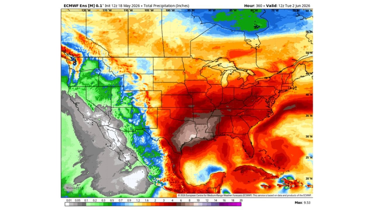
NEW ORLEANS, Louisiana – A strong and persistent wet pattern is locking in across the South through Tuesday, June 2, 2026, with total precipitation forecasts reaching a maximum of 9.53 inches across the southern tier of the country. Flooding is expected to become a major headline story as May winds down across Texas, Louisiana, Mississippi and Alabama, with a significant above-normal rainfall anomaly showing across the entire South through Saturday, May 30.
How Much Rain Is Coming Through June 2
The total precipitation forecast valid through Tuesday, June 2 shows dramatically different outcomes depending on where you live across the country.
| Region | Forecast Total Rainfall |
|---|---|
| South Texas and Gulf Coast | 8 to 9.53 inches |
| Louisiana and Mississippi | 6 to 8 inches |
| Alabama and Tennessee | 4 to 6 inches |
| Mid-Atlantic and Southeast Coast | 3 to 5 inches |
| Central Plains and Midwest | 2 to 4 inches |
| Northwest Plains and Rockies | Under 1 inch, drier than normal |
The maximum value on the entire map reaches 9.53 inches across the South, confirming this is a historic rainfall signal for the southern United States through June 2.
The 10 Day Rainfall Anomaly Through May 30 Tells the Full Story
The 10 day rainfall anomaly valid through Saturday, May 30 shows just how far above normal the precipitation pattern is for the South:
The deepest blue shading on the anomaly map, indicating the greatest above-normal rainfall departure, covers a broad zone from South Texas and the Gulf Coast northeast through Louisiana, Mississippi, Alabama and into Tennessee, Kentucky and the Mid-Atlantic. This means not only is significant rainfall coming, it is arriving on top of what is already an active precipitation period for these states. The Plains and Rockies show a drier than normal anomaly, meaning the wet pattern is highly focused on the South and East through May 30.
Why Flooding Is the Big Concern
A signal this strong for above-normal rainfall across the South through June 2 raises serious flooding concerns for several reasons. Ground across parts of Louisiana, Mississippi and Alabama may already be saturated from ongoing storm activity. Rivers and streams across the South that are already running at elevated levels will have little capacity to absorb additional rainfall of 6 to 9 inches over the next two weeks. The pattern also shows a persistent ridge of high pressure dominating the eastern United States through May 30, which tends to slow storm systems down and cause them to train over the same areas repeatedly, a classic setup for flash flooding and river flooding events.
The Bigger Pattern Through May 30
The atmospheric setup driving this wet pattern shows above-normal heights and warmth dominating the eastern United States from Wednesday, May 20 through Saturday, May 30. This ridge acts like a wall that forces moisture-laden storm systems to stall across the South rather than moving efficiently out to sea. When storm systems stall over already wet ground, rainfall totals compound quickly and flooding becomes the primary danger rather than any individual severe weather threat.
Residents across Texas, Louisiana, Mississippi, Alabama and Tennessee should begin monitoring flooding forecasts closely now and have an emergency plan ready before the heaviest rainfall arrives later this week and into next week.
WaldronNews.com will continue tracking this major flooding threat across the South and will provide updates as rainfall totals, river levels and flood warnings develop through Tuesday, June 2.