
Flash Flood Emergency Growing for South Central Indiana and Illinois With 3 Inch Plus Rain Already Fallen and Several More Inches Coming Through Tuesday Morning May 19 Including Terre Haute, Columbus and Indianapolis
TERRE HAUTE, Indiana – Forecasters are growing very concerned about flash flooding across south central Indiana and Illinois tonight as training storms dump 3 inches or more of rainfall over the same areas repeatedly, with several more inches likely before the pattern ends by Tuesday morning, May 19 at 7:00 AM EDT. Terre Haute, Columbus and Greenwood are among the hardest-hit communities with dangerous flash flooding developing right now.
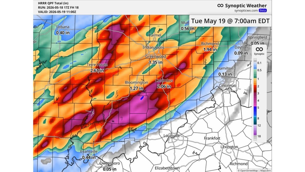
Rainfall Totals Through Tuesday Morning May 19 at 7 AM EDT
The forecast totals through Tuesday, May 19 at 7:00 AM EDT show a dangerous and highly concentrated rainfall pattern across Indiana:
| City | Forecast Rainfall Total |
|---|---|
| Terre Haute, Indiana | 2.61 inches additional |
| Columbus, Indiana | 2.06 inches additional |
| Richmond, Indiana | 1.94 inches additional |
| Greenwood, Indiana | 1.35 inches additional |
| Bloomington, Indiana | 1.27 inches additional |
| Lafayette, Indiana | 1.62 inches additional |
| Evansville, Indiana | 0.44 inches additional |
| Muncie, Indiana | 0.56 inches additional |
| Urbana, Illinois | 0.40 inches additional |
These totals are on top of 3 or more inches already fallen across south central Indiana and Illinois before this forecast was issued, meaning total storm rainfall in the worst-hit areas could reach 5 to 6 inches or more by Tuesday morning, May 19.
Why Training Storms Make This Especially Dangerous
The term forecasters are using tonight is “training,” which means storm after storm is following the exact same path over the same communities, stacking rainfall totals that would normally be spread across a much wider area. Think of it like a train with many cars all passing over the same bridge. Each storm adds another inch or two on top of what the last storm already dropped. Ground across south central Indiana and Illinois that has already absorbed 3 inches tonight simply cannot take several more inches. The result is rapidly rising water in streets, fields, creeks and rivers with little time to react.
Flash Flooding Is Happening Right Now
Multiple areas across south central Indiana and Illinois are already seeing 3 inches or more of rainfall as of tonight, Monday, May 18, with several more inches still on the way through Tuesday morning, May 19. Fields across central Indiana are already reporting standing water several inches deep. Roads and low-lying areas near Terre Haute, Columbus, Greenwood and Bloomington face active and worsening flash flood conditions tonight.
Do not drive through any flooded roadway tonight or early Tuesday morning. Water levels can rise faster than headlights reveal the danger ahead. Six inches of moving water can knock an adult off their feet. Twelve inches will sweep most vehicles away.
What To Do Right Now
If you are in Terre Haute, Columbus, Greenwood, Bloomington, Richmond or Lafayette, Indiana move away from low-lying areas, creek banks and flood-prone roads immediately. Move to higher ground if your home or neighborhood is in a flood-prone area. Do not wait for emergency services to tell you to move. Flash floods can rise several feet in minutes and trap people without warning. Stay off all roads in south central Indiana and Illinois through Tuesday morning, May 19.
WaldronNews.com will continue tracking this flash flooding emergency across south central Indiana and Illinois and will provide updates as flood reports, road closures and rainfall totals develop through Tuesday morning, May 19.