
Alabama and the Gulf Coast Face a Hotter Drier Summer as El Nino Emerges With 61% Chance Through End of 2026
BIRMINGHAM, Alabama — A major climate shift is underway that will define summer and fall across the Gulf Coast and Deep South — El Niño is emerging, with a 61% chance of developing between May and July 2026 and persisting through at least the end of 2026. For Alabama, Mississippi, Louisiana, and surrounding states, this means one thing above all else: a hotter, drier summer than normal is increasingly likely.
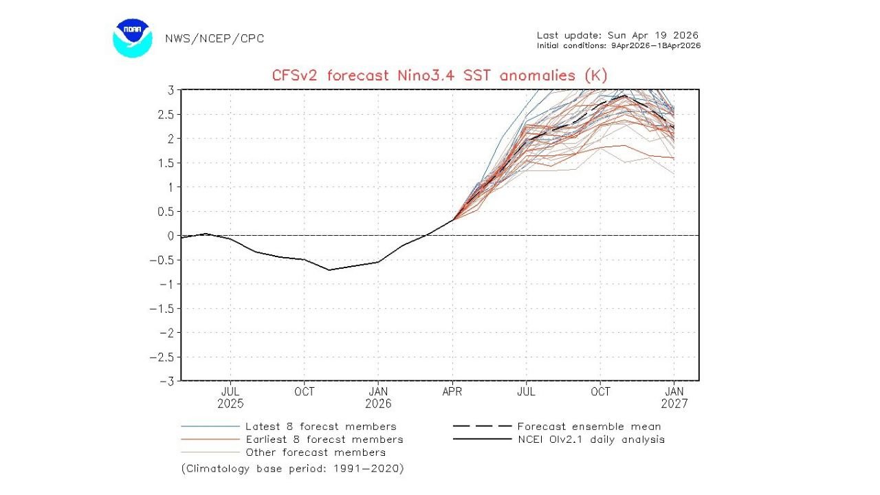
The ocean temperature forecast charts show a dramatic shift already underway — Pacific temperatures that sat below normal through early 2026 are now surging rapidly upward, with ensemble forecasts pointing toward +2.0 to +2.5°C anomalies by fall — a significant El Niño event, not a marginal one.
States Most Affected by the 2026 El Niño Pattern
The El Niño influence will be felt differently across the country, but the Gulf South faces the most direct summer impacts:
- Alabama: Birmingham, Huntsville, and Mobile — 89% of the state already in drought, facing a summer with less tropical rainfall than normal
- Mississippi: Jackson and surrounding areas — El Niño suppresses the tropical storm rainfall that normally breaks summer dry spells
- Louisiana: New Orleans and Baton Rouge — Gulf hurricane threat reduced but summer heat and drought risk elevated
- Florida: Tampa and the Gulf Coast — less active hurricane season but hotter, drier inland conditions
- Georgia: Atlanta and southern Georgia — drought conditions likely to persist or worsen through summer
- Texas: Houston and the Gulf Coast — reduced tropical rainfall increases summer heat and drought stress
What El Niño Actually Means for Your Summer
El Niño is not just a weather term — it has direct, real-world consequences for millions of people across the South:
- Weaker Atlantic hurricane season — El Niño pumps extra wind shear across the Caribbean and Atlantic, physically tearing apart developing tropical storms before they can organize into hurricanes. This is good news for Gulf Coast communities — but it comes with a trade-off
- Less summer rainfall for Alabama — most of Alabama’s meaningful summer rain comes from tropical systems tracking inland. With El Niño suppressing those systems, the afternoon pop-up storms that remain rarely produce the widespread, soaking rainfall that breaks drought
- Hotter than normal temperatures — fewer clouds, less rainfall, and drier soil means temperatures run above average through the summer months across the Deep South
- Drought deepening — with 89% of Alabama already in drought and El Niño reducing the tropical rainfall that would normally provide relief, the drought could intensify significantly through summer if late April and May rains disappoint
Why the Next 6 to 7 Weeks Are Critical for Alabama
Birmingham, Alabama and the entire state are sitting at a crossroads right now. The drought covering 89% of Alabama is already serious — soils are dry, reservoirs are stressed, and vegetation is parched after months of below-normal rainfall across the Southeast.
The next 6 to 7 weeks — late April through May — represent the last realistic window to receive meaningful drought relief before El Niño’s grip tightens through summer. Spring frontal systems can still deliver significant rainfall to the region during this window, unlike summer when the pattern locks in and tropical rainfall becomes the primary moisture source.
If those spring rains fail to materialize in generous amounts, Alabama and the broader Gulf South will enter summer already depleted — and then face a summer where the tropical rainfall that normally provides relief is actively suppressed by El Niño wind shear. That combination sets up what could be a long, hot, drought-stressed summer for the region.
The forecast chart tells the full story: Pacific temperatures are climbing sharply and nearly every ensemble member agrees on a strong El Niño by summer. This is not a borderline signal — the atmospheric and oceanic patterns are aligning toward a significant event.
Multi-Day Pattern
The immediate focus remains on late April rain chances for Alabama and the Southeast as spring frontal systems continue moving through the region. Every rain event between now and June matters enormously for drought recovery. Beyond that, the El Niño transition through May-July means summer forecasts will increasingly lean toward above-normal heat and below-normal rainfall across Alabama, Mississippi, and the broader Gulf South through the end of 2026.
What to Watch Next
- Late April and May rainfall totals across Alabama — critical window for drought recovery before summer
- Whether any spring systems deliver the generous rain amounts needed to make a dent in the 89% drought coverage
- Gulf of Mexico water temperatures as summer approaches — warm Gulf water can partially offset El Niño’s hurricane suppression
- Official summer outlook updates confirming above-normal heat probability for the Deep South
- Whether El Niño intensifies beyond the current +2.0 to +2.5°C forecast range into a stronger event
Residents across Alabama, Mississippi, Louisiana, and the Gulf Coast should be thinking ahead — water conservation, lawn and garden planning, and awareness of heat safety will all be increasingly important as summer approaches under a developing El Niño pattern.
WaldronNews.com will continue tracking the El Niño development and its impacts on the Gulf South through summer 2026.