
Alabama Gets 2 to 4 Inches of Badly Needed Rain This Week With Severe Weather Risk Monday Targeting Birmingham, Huntsville and Tuscaloosa
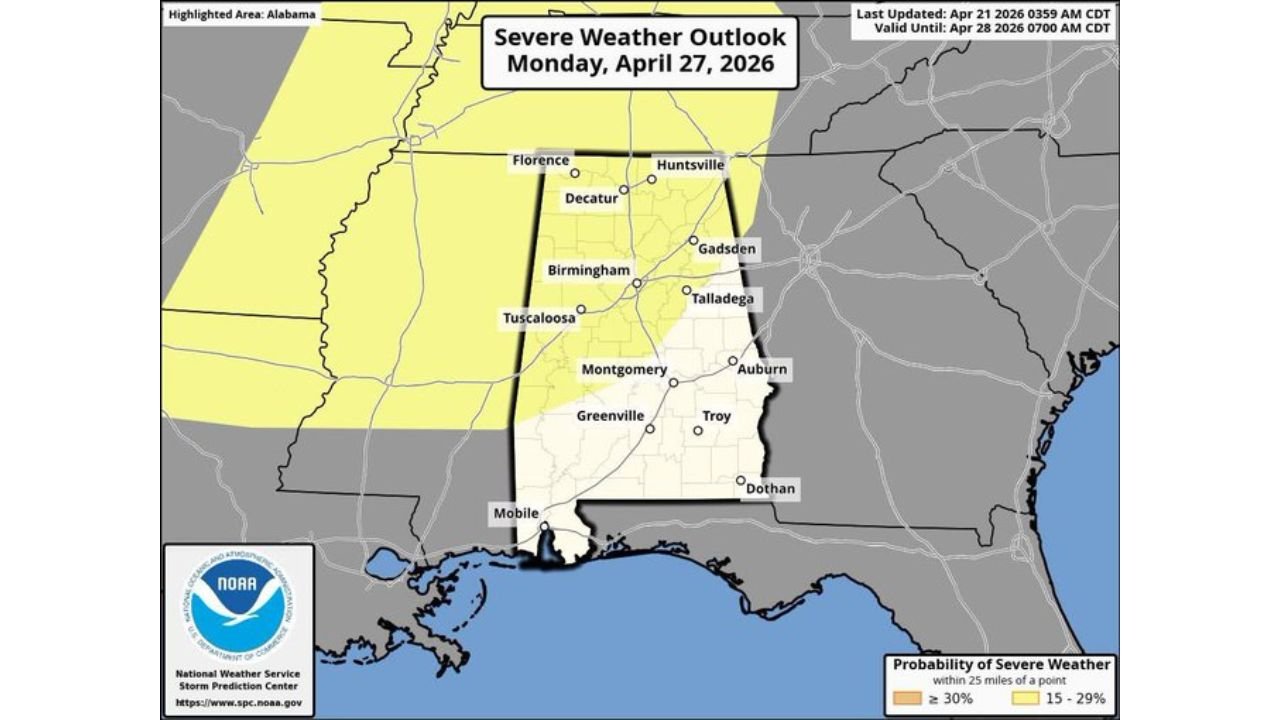
BIRMINGHAM, Alabama — A pattern change is finally arriving for drought-stricken Alabama — and it brings both good news and a serious warning. 2 to 4 inches of badly needed rainfall are forecast across North and Central Alabama through Tuesday, April 28, with the heaviest totals arriving Friday night, Saturday, and again Monday through Tuesday. But Monday also carries a severe weather risk already defined for much of North and Central Alabama, with Birmingham, Huntsville, Tuscaloosa, and Montgomery all inside the outlined threat zone.
The rain is desperately needed. 89% of Alabama is currently in drought. But the storms delivering that rain on Monday could turn dangerous.
Alabama Cities in the Rain and Severe Weather Zone
The 7-day rainfall and Monday’s severe outlook cover the same corridor:
- Huntsville, Alabama: Northern Alabama sitting in the 15–29% severe weather probability zone Monday — Florence and Decatur also included
- Birmingham, Alabama: Dead center of both the heavy rain forecast and Monday’s severe weather outlook
- Tuscaloosa, Alabama: Inside the severe weather risk zone with 2.8 to 3.5 inch rainfall totals forecast for the week
- Montgomery, Alabama: Central Alabama in the severe weather outline with 2.0 to 3.1 inch weekly rain totals
- Gadsden and Talladega: Eastern Alabama communities inside the Monday risk corridor
- Auburn and Troy: Southeastern edge of the severe weather outline for Monday
Primary Threats This Week
The next seven days bring two separate weather stories for Alabama:
- 2 to 4 inches of rainfall across North Alabama through April 28 — the highest totals in the 3.0 to 3.5 inch range focused across the north-central part of the state, with 1.6 to 2.0 inches across southern counties
- Friday night and Saturday — first heavy rain window arrives, delivering the bulk of the week’s early moisture
- Monday and Tuesday — second and potentially more significant rain event, also carrying a severe weather threat for North and Central Alabama
- Strong to severe storms Monday — the severe weather outlook covers Birmingham, Huntsville, and Tuscaloosa with a 15–29% probability of severe weather within 25 miles of any point in the risk zone
- Timing and magnitude still uncertain — forecasters acknowledge it is too early to know exactly how strong Monday’s storms will be, but the threat is real enough to already appear on official outlooks
Why This Rain Matters So Much — and Why Monday’s Storms Could Turn Dangerous
Birmingham, Alabama has been suffering through one of the worst droughts in the state’s recorded history. With 89% of Alabama in drought and rainfall running 15 to 20 inches below normal since October, the 2 to 4 inch forecast for this week is genuinely meaningful — but it must be kept in perspective.
A week of 2 to 4 inch rainfall totals is a significant start. It will provide relief to stressed vegetation, help with fire danger, and begin recharging extremely depleted soil moisture. But recovering from a 15 to 20 inch rainfall deficit requires consistent above-normal precipitation for weeks to months — not a single good week. Think of this as the drought’s first serious challenge, not its end.
The Monday severe weather threat is the complicating factor. The same atmospheric pattern shift that is finally breaking the dry spell and delivering rainfall is also capable of producing dangerous storms on Monday. North Alabama — including the Huntsville and Birmingham corridors — already has a defined severe weather risk for April 27, and that outlook will sharpen considerably as the event gets closer.
North Alabama’s geography makes it particularly vulnerable to severe weather. The Tennessee Valley corridor running through Huntsville, Decatur, and Florence has a long history of significant tornado events — the terrain can actually enhance storm rotation under the right atmospheric conditions. With the severe weather risk already defined this far in advance, residents should treat Monday as a legitimate threat day, not just another rainy day.
Multi-Day Pattern
Wednesday through Thursday remain relatively dry as the pattern transition begins. Friday night marks the first rain arrival — moderate to heavy coverage possible across North and Central Alabama. Saturday continues the rain with additional accumulation across the state. Sunday offers a brief break as the atmosphere reloads. Monday and Tuesday bring the second and potentially stronger system — rain totals climb further while severe weather becomes the primary concern across North Alabama. Beyond Tuesday, the pattern continues to favor more frequent rain chances across the Deep South as the overall upper air pattern remains active.
What to Watch Next
- Weekend rain totals Friday night and Saturday — whether North Alabama picks up meaningful drought-relieving amounts
- Monday’s severe weather outlook upgrades — whether the risk level rises above the current 15–29% probability as the event comes into range
- Tornado watch potential for the Birmingham and Huntsville corridors Monday afternoon and evening
- 7-day rainfall verification — whether the 3.0 to 3.5 inch bull’s-eye over North Alabama actually delivers
- Drought monitor update in early May reflecting the week’s rainfall impact on Alabama’s historic drought
Residents across Birmingham, Huntsville, Tuscaloosa, and Montgomery should welcome the rain forecast this week — and stay weather-aware heading into Monday. The same storms bringing drought relief could bring dangerous conditions. Have a shelter plan ready before Monday arrives.
WaldronNews.com will continue tracking Alabama’s drought-relief rain chances and Monday’s severe weather threat and provide updates as both events develop through the week.