
Central Texas Faces 2 to 3 Inches of Heavy Rain Today as 70-Knot Jet Stream and Moisture Surge Target the Hill Country Triangle
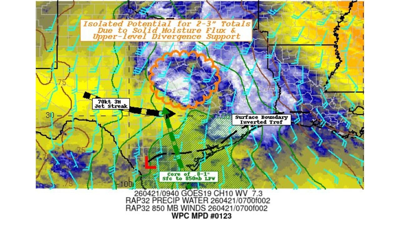
SAN ANTONIO, Texas — A powerful atmospheric setup is targeting central Texas right now — a 70-knot jet streak combining with a strong moisture surge and upper-level support is generating isolated potential for 2 to 3 inches of rainfall across the Hill Country Triangle region today. A formal mesoscale discussion is already in effect for the area, signaling that forecasters are watching this setup closely for flooding potential.
The heaviest rain is focused on a concentrated zone where moisture flux and upper-level divergence are working together — and in central Texas, that combination can produce rainfall totals that overwhelm drainage systems fast.
Central Texas Areas in the Heavy Rain Zone
The threat is focused on the Hill Country and surrounding Triangle region:
- San Antonio, Texas: On the southern edge of the heavy rain zone as the moisture surge pushes north
- Austin, Texas: Central Texas metro watching the rainfall potential through today
- Hill Country corridor: The core zone where 2 to 3 inch isolated totals are possible where the moisture flux and jet streak intersect
- Waco area: Northern fringe of the affected region as the surface boundary extends northeast
- San Angelo corridor: Western Texas on the edge of the moisture axis
Primary Threats Today
The setup carries specific flood-related dangers:
- 2 to 3 inches of rain in isolated locations — that amount falling in a short period over the rocky Hill Country terrain creates rapid runoff and flash flood potential
- 70-knot jet streak — an exceptionally powerful upper-level wind feature driving strong lift and heavy rainfall rates in the core storm zone
- Surface boundary and inverted trough — a surface boundary across central Texas is focusing storm development and rainfall in a concentrated zone rather than spreading it out
- Flash flood risk — the Hill Country’s rocky, thin-soil terrain does not absorb heavy rainfall well; water runs off quickly into creeks and low-water crossings
Why Central Texas Flash Flood Risk Is Always Serious
San Antonio, Texas and the broader central Texas Hill Country sit in one of the most flash-flood-prone regions in the entire United States. The geology of the Edwards Plateau — limestone bedrock, thin soils, and deeply cut creek valleys — means that heavy rainfall has nowhere to go except into the streams and river systems that drain toward San Antonio, Austin, and the surrounding communities.
The 2 to 3 inch isolated rainfall potential highlighted in this discussion may not sound alarming on its own — but in central Texas Hill Country terrain, that amount falling over a few hours is more than enough to send normally dry creek beds into raging torrents. Low-water crossings — of which there are hundreds across the Hill Country — can go from dry to impassable in minutes when storms produce this kind of rainfall upstream.
The 70-knot jet streak is the atmospheric engine driving this event. That level of upper-level wind energy provides intense lift, pulling moisture rapidly upward and generating heavy rainfall rates in the storm cores. Combined with the solid moisture flux feeding Gulf moisture northward into the region, the atmosphere has the fuel and the trigger to produce localized rainfall totals that far exceed what looks manageable on a forecast map.
The surface boundary and inverted trough are keeping storm activity anchored over the same general area rather than moving through quickly — a key factor in producing high totals. Slow-moving or training storms over the same location are the primary producer of flash floods in Texas.
Multi-Day Pattern
Today’s heavy rain event is localized to central Texas as this specific atmospheric setup fires. The broader pattern shifts as the week progresses — Thursday’s major severe weather outbreak across Kansas, Nebraska, Iowa, and Illinois represents the next significant national event as the same energy complex moves northeast. Central Texas returns to drier conditions by midweek before the next pattern cycle arrives late in the week.
What to Watch Next
- Rainfall totals from Hill Country rain gauges today — whether isolated totals reach or exceed the 2 to 3 inch threshold
- Flash flood warnings for Bexar, Kerr, Gillespie, and surrounding Hill Country counties
- Low-water crossing conditions across the Guadalupe, Medina, and Nueces River watersheds
- Whether storm activity trains over the same location, increasing flood totals above the isolated forecast
- San Antonio and Austin area urban flooding reports as runoff moves into city drainage systems
Residents across central Texas — particularly in the Hill Country and anyone who regularly crosses low-water crossings — should never drive through flooded roads today. Two to three inches in the wrong place upstream can make a crossing deadly with no warning.
WaldronNews.com will continue tracking central Texas heavy rain and flash flood potential and provide updates as storm totals develop today.