
Corn Belt and Eastern Ag Belt Face Active 2 Week Rainfall Stretch May 18 Through May 31 With Scattered Rain Opportunities While West Central and Northwestern Plains Stay Drier
CHICAGO, Illinois – An active 2 week precipitation stretch is underway for most of the country, with scattered rain opportunities hitting the Corn Belt and Eastern Ag Belt through Sunday, May 24 and continuing into the May 25 through May 31 period. Consecutive dry days will be hard to come by across these regions, while the West Central and Northwestern Plains remain on the drier side through both weeks.
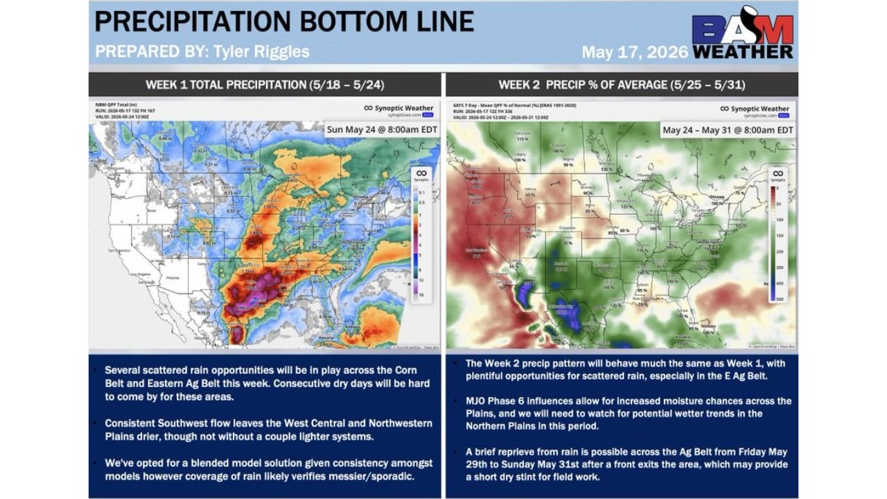
Week 1 Precipitation Outlook May 18 Through May 24
The first week of this active pattern covers Monday, May 18 through Sunday, May 24:
- Several scattered rain opportunities will be in play across the Corn Belt and Eastern Ag Belt this week, making consecutive dry days hard to come by for farmers and residents across these areas through Sunday, May 24.
- Consistent southwest flow leaves the West Central and Northwestern Plains drier through Sunday, May 24, though a couple of lighter rain systems are still possible in those areas during this period.
- Rain coverage during Week 1 is expected to verify as messier and more sporadic than any single model solution suggests, meaning some areas will see significantly more rain than neighbors just miles away through May 24.
Week 2 Precipitation Outlook May 25 Through May 31
The second week of the outlook covers Monday, May 25 through Sunday, May 31:
- The Week 2 precipitation pattern is expected to behave much the same as Week 1, with plentiful opportunities for scattered rain continuing especially across the Eastern Ag Belt through May 31.
- Increased moisture chances are possible across the Plains during the May 25 through May 31 period, with potential wetter trends developing across the Northern Plains that will need to be monitored closely.
- A brief reprieve from rain is possible across the Ag Belt from Friday, May 29 through Sunday, May 31 after a front exits the area, which may provide a short dry window for field work before the pattern turns active again.
What This 2 Week Pattern Means for the Ag Belt
Two consecutive weeks of scattered but frequent rainfall across the Corn Belt and Eastern Ag Belt means field conditions will remain challenging through May 31. Planting and harvesting operations that require dry ground will face repeated interruptions as rain chances return every few days. The brief dry window possible from May 29 through May 31 may be the best opportunity for fieldwork during this entire 2 week stretch.
Plains Dryness Is a Different Concern
While the Corn Belt and Eastern Ag Belt deal with too much rain, the West Central and Northwestern Plains face the opposite problem through May 24. Consistent southwest flow keeping these areas drier could stress crops and increase fire weather concerns if winds pick up during dry periods across the Northwestern Plains.
WaldronNews.com will continue tracking this active 2 week precipitation pattern across the Corn Belt, Eastern Ag Belt and Plains and will provide updates as rainfall totals and dry window timing develop through Sunday, May 31.