
Kansas and Nebraska Face Strong to Intense Tornadoes and 3 Inch Plus Hail Monday May 18 Starting 2 to 3 PM Including Concordia, Salina, Minneapolis, Hastings and Hebron With 60 to 90 mph Winds if Storms Go Linear
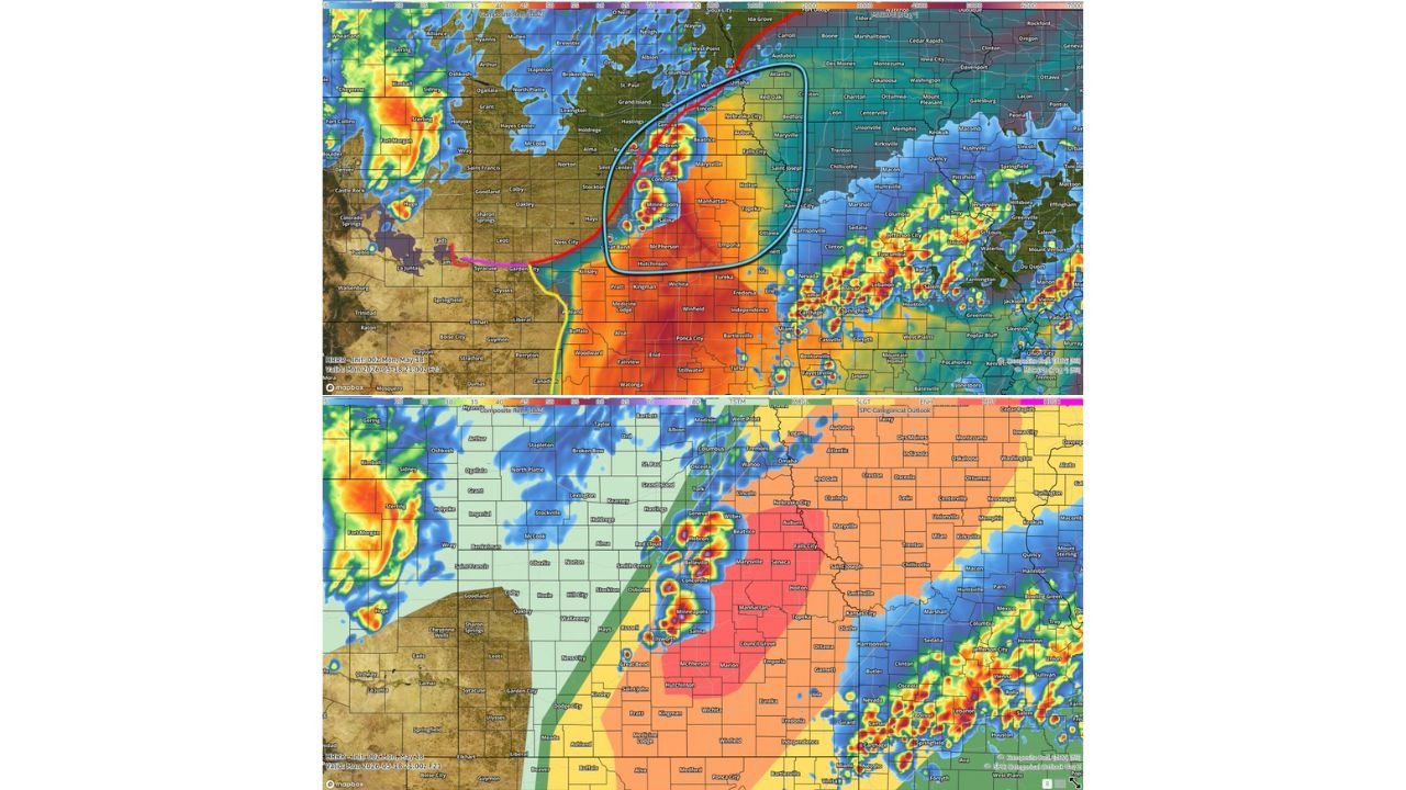
CONCORDIA, Kansas – Several supercells are expected to fire along a stationary warm front across central and northern Kansas into southeast Nebraska and possibly western Iowa starting around 2:00 to 3:00 PM CDT Monday, May 18. The environment is described as extremely volatile, capable of producing 3 inch or larger hail and strong to intense tornadoes if supercells remain discrete, with 60 to 90 mph damaging winds possible if storms transition into a line after 6:00 PM CDT.
Two Scenarios for Monday May 18
The outcome for Monday, May 18 hinges on one critical question: how long can supercells stay discrete before the cold front crashes into them.
- If supercells remain discrete for 2 to 3 hours after firing around 2:00 to 3:00 PM CDT, the environment across central and northern Kansas and southern Nebraska supports 3 inch or larger hail and several strong to intense tornadoes. This is the most dangerous tornado scenario for Monday, May 18.
- If the cold front surges faster than expected, storms merge into a line after 6:00 PM CDT across eastern Kansas, southeast Nebraska and southwest and western Iowa, shifting the primary threat to 60 to 90 mph damaging winds and several tornadoes including a few strong ones embedded in the line.
Cities in the Core Supercell Firing Zone
The heaviest storm activity is focused across central and northern Kansas and southern Nebraska starting 2:00 to 3:00 PM CDT Monday:
- Concordia, Minneapolis and Salina, Kansas sit at the center of the supercell firing zone and face the greatest threat of 3 inch or larger hail and strong to intense tornadoes Monday afternoon.
- Hebron, Belleville, Red Cloud, Geneva and Hastings, Nebraska are within the core supercell corridor and face all severe hazards Monday afternoon starting around 2:00 to 3:00 PM CDT.
- Smith Center, Osborne, Russell and Ellsworth, Kansas fall directly within the storm initiation zone and face 3 inch plus hail and a real tornado threat Monday afternoon.
- Great Bend, McPherson, Hutchinson and Kingman, Kansas sit on the southern edge of the supercell corridor and should prepare for dangerous storms Monday afternoon and evening.
- Manhattan and Topeka, Kansas are within the broader severe weather threat area and face the risk of significant storms pushing through Monday afternoon and evening.
Cities Facing the Linear Wind Threat After 6 PM
As storms are expected to transition toward a line after 6:00 PM CDT, the damaging wind threat extends into a wider area:
- Omaha, Lincoln, Beatrice, Nebraska City, Marysville and Falls City, Nebraska are within the zone where the storm line is expected to push through Monday evening with 60 to 90 mph wind gusts possible.
- Kansas City, Holton, Saint Joseph and Ottawa, Kansas face the eastern edge of the linear wind threat as the storm complex pushes east Monday evening.
- Atlantic, Red Oak, Creston and Clarinda, Iowa are in the path of the storm line pushing into western Iowa after 6:00 PM CDT Monday.
What 3 Inch Plus Hail and 60 to 90 mph Winds Can Do
3 inch or larger hail will total vehicles, shatter windows and punch through roofs across central and northern Kansas and southern Nebraska Monday afternoon. 60 to 90 mph straight-line winds from a linear storm mode are capable of snapping trees at the trunk, collapsing structures, downing power lines across wide areas and flipping high-profile vehicles. Both threat modes on Monday, May 18 are life-threatening and deserve the same level of respect and preparation.
Critical Timing to Know Monday
- 2:00 to 3:00 PM CDT: Supercells expected to fire across central and northern Kansas and southern Nebraska. Greatest tornado and large hail window begins.
- Through 6:00 PM CDT: Discrete supercell mode most favorable. Strong to intense tornadoes and 3 inch plus hail are the primary threats across Concordia, Salina, Minneapolis, Hastings and Hebron.
- After 6:00 PM CDT: Storm line expected to develop across eastern Kansas, southeast Nebraska and western Iowa, shifting the threat to 60 to 90 mph winds and embedded tornadoes through Monday evening.
What You Must Do Before 2 PM Monday
Anyone across Concordia, Salina, Minneapolis, Hastings, Hebron, Great Bend, Hutchinson and surrounding Kansas and Nebraska communities must be fully weather-alert ready before 2:00 PM CDT Monday, May 18. Know your tornado shelter location now. Move all vehicles under solid cover before noon Monday. Keep weather alerts active on your phone all afternoon and evening. Do not be outdoors when storms fire at 2 to 3 PM. An intense tornado or 3 inch hailstone can be lethal with zero warning.
WaldronNews.com will continue tracking this strong to intense tornado and 3 inch plus hail threat across Kansas and Nebraska and will provide updates as supercell development, tornado warnings and wind reports emerge throughout Monday, May 18.