
Nebraska, Kansas and Iowa Face Localized 3 Inch Plus Rainfall Through Tuesday Morning May 19 With Scattered 1 to 2 Inch Totals Reaching Minneapolis, Milwaukee and Cedar Rapids
OMAHA, Nebraska – A multi-day severe weather event now underway across the Plains is delivering much-needed rainfall from Sunday, May 17 through Tuesday morning, May 19, with localized totals of 3 inches or more possible across Nebraska and Kansas and scattered totals of 1 to 2 inches or more reaching Minnesota, Iowa, Wisconsin and Illinois. Drier trends are expected as June approaches after this active stretch winds down.
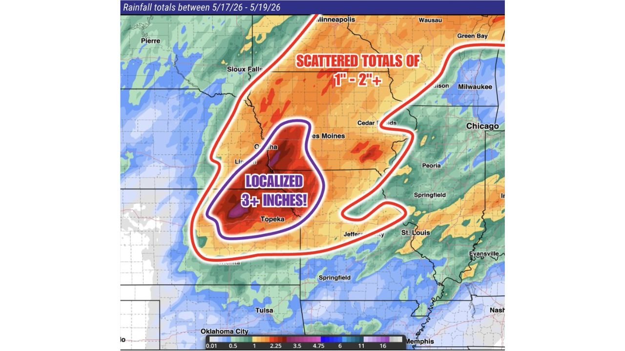
Two Rainfall Zones Through Tuesday Morning May 19
The modeled rainfall totals between May 17 and May 19 show two clearly defined zones:
- The Localized 3 inch or more zone shown in purple covers the core heavy rainfall corridor centered on Omaha, Lincoln and Topeka, where the heaviest storm totals from this multi-day event will concentrate through Tuesday morning, May 19. Flash flooding is a real concern anywhere receiving 3 inches or more of rain within a short period.
- The Scattered 1 to 2 inch or more zone shown by the red outline covers a much wider area including Sioux Falls, Minneapolis, Des Moines, Cedar Rapids, Milwaukee, Madison, Chicago, Peoria, Springfield, St. Louis and Jefferson City, where scattered but significant rainfall totals are expected through Tuesday morning, May 19.
Cities Facing the Heaviest Rainfall Through Tuesday
- Omaha and Lincoln, Nebraska sit inside the localized 3 inch or more zone and face the greatest flood risk from this rainfall event through Tuesday morning, May 19.
- Topeka, Kansas is within the 3 inch plus localized zone and should monitor drainage and low-lying road conditions closely through Tuesday, May 19.
- Des Moines and Cedar Rapids, Iowa fall within the scattered 1 to 2 inch plus zone and can expect meaningful rainfall accumulations through Tuesday morning.
- Sioux Falls, South Dakota sits on the northern edge of the scattered rainfall zone with 1 to 2 inch plus totals possible through Tuesday, May 19.
- Minneapolis, Minnesota and Milwaukee and Wausau, Wisconsin are within the scattered 1 to 2 inch plus corridor through Tuesday morning, May 19.
- Chicago, Peoria and Springfield, Illinois along with St. Louis and Jefferson City, Missouri fall within the broader scattered rainfall zone through Tuesday, May 19.
- Tulsa, Oklahoma and Oklahoma City sit on the southern edge of the rainfall pattern with lighter totals expected through Tuesday morning.
Why 3 Inch Plus Rain Matters for Nebraska and Kansas
3 inches or more of rainfall delivered over the course of this multi-day event from May 17 through May 19 can overwhelm drainage systems, saturate already wet fields and cause rapid rises in streams and rivers across Nebraska and Kansas. Low-lying roads, underpasses and creek crossings near Omaha, Lincoln and Topeka face flooding risk through Tuesday morning, May 19. Turn around and do not drive through flooded roadways under any circumstances.
Drier Trends Coming After This Event
While this multi-day rainfall event is delivering much-needed moisture across the Plains, forecasters are noting that drier trends are anticipated as June approaches. This makes the current rainfall window particularly valuable for agricultural areas that have been waiting for significant precipitation. Farmers and producers across Nebraska and Kansas should take note of the localized 3 inch plus totals possible through Tuesday morning, May 19.
WaldronNews.com will continue tracking these rainfall totals across Nebraska, Kansas and Iowa and will provide updates as storm totals, flooding reports and drier trend timing develop through Tuesday morning, May 19.