
Kansas and Oklahoma Face Violent Tornado Outbreak Saturday Afternoon as Supercells With 3500 CAPE Target Wichita and Oklahoma City
WICHITA, Kansas — The atmosphere across Kansas and Oklahoma is building toward a dangerous tornado outbreak setup for Saturday, April 18, and the data coming in is not subtle. Forecasters are describing the northern zone as having “classic hodographs for a big tornado outbreak” — a phrase that carries serious weight — while the sounding data for the southern Kansas region is showing one of the most alarming atmospheric profiles seen this spring.
This is a two-area threat for Saturday, and both zones are being taken seriously. The northern corridor carries the pure tornado outbreak ingredients. The southern zone along the Kansas-Oklahoma border is loaded with its own dangerous supercell potential. Together they create a setup that demands immediate attention from every community across the Southern Plains.
States and Cities That Face the Greatest Risk Saturday
- Kansas: Wichita, Dodge City, Liberal, Garden City — sitting in the heart of the southern supercell zone with the most extreme atmospheric sounding data
- Kansas: Central and eastern Kansas communities watching the northern outbreak corridor develop through the afternoon
- Oklahoma: Oklahoma City, Tulsa, Enid, Woodward — directly in the path of supercell development from both the northern and southern zones
- Kansas-Oklahoma border region: The overlap zone where both areas of interest converge — the most volatile corridor for Saturday’s threat
- Texas: Northern Texas panhandle communities watching the southern dryline supercell threat push in from the west
What the Sounding Data Is Screaming for Saturday
The atmospheric sounding valid Saturday near the Kansas-Oklahoma border is one of the most concerning profiles of the entire spring season so far.
- CAPE values of 3,526 J/kg at the surface — extreme fuel for violent storm development
- 3CAPE of 40 — the explosive low-level energy that drives the most dangerous and intense updrafts
- Critical Angle of 92 degrees — nearly perfect. This specific value means the wind shear orientation is almost ideally aligned to produce tornadic supercells. Anything near 90 degrees is considered textbook tornado country
- Storm Relative Helicity running extremely high — the rotational energy in the lower atmosphere is loaded and ready for any supercell that can tap into it
- Significant Tornado Parameter values well above the threshold where tornado production becomes highly likely with supercells
- Possible Hazard Type flagged as TOR — the sounding analogs are pointing directly at tornado-producing supercell as the most likely storm type Saturday afternoon
- Bunkers storm motion at 253/39 kt — storms moving fast, which means tornado warnings will require immediate action with very short response windows
- 700 mb wave arriving by early afternoon — the upper-level trigger that fires storms and keeps them organized through the peak heating hours
The Northern Zone — Classic Outbreak Setup
The northern area of interest for Saturday carries what forecasters are calling “classic hodographs for a big tornado outbreak.” That language is not used lightly.
A hodograph is a technical tool that shows how wind speed and direction change with height in the atmosphere. When forecasters describe one as “classic for a big tornado outbreak,” they are saying the wind profile looks nearly identical to the profiles seen before some of the most significant tornado outbreaks on record.
The open warm sector ahead of the approaching system gives storms room to develop as discrete supercells before the cold front arrives and forces a transition to squall line mode. That window — when organized supercells are operating in an open warm sector with classic hodographs — is exactly when the most violent and longest-track tornadoes occur.
The uncertainty remains storm mode — whether storms stay as clean discrete supercells or merge into a messier cluster. But the forecaster making this assessment says clearly: “the environment alone supports a high risk for tornadoes.” The atmosphere is doing its part. Whether the storm mode cooperates will be answered in real time Saturday afternoon.
The Upper Level Setup Driving Everything
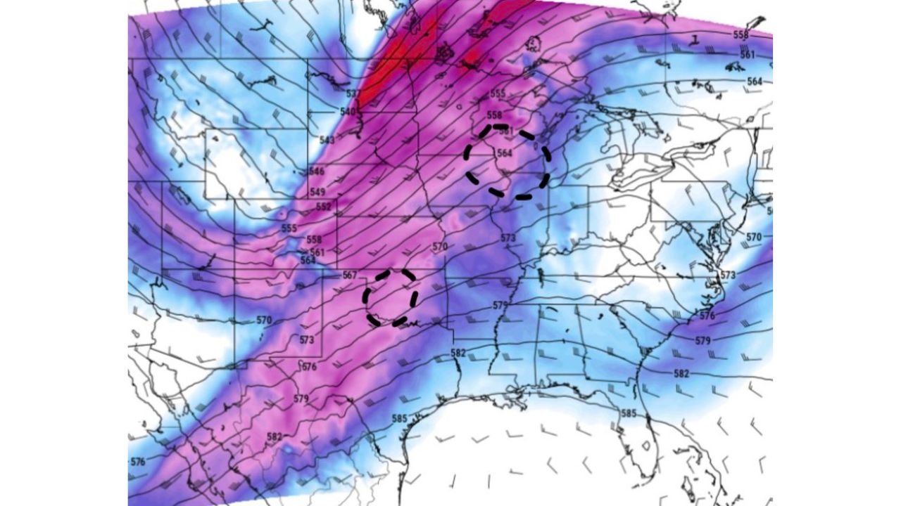
The 500 mb height and wind map shows a powerful deep trough digging into the Central Plains for Saturday — the deep purple and magenta colors on the upper-level map represent an exceptionally strong jet stream pattern slamming into the region. Two separate circulation centers marked with dashed circles are visible — one over the northern Plains driving the outbreak corridor, and one over the southern Kansas-Oklahoma area anchoring the southern supercell zone.
This kind of upper-level support — strong jet energy directly overhead combined with a sharply digging trough — is what separates a busy severe weather day from a genuine outbreak day. The dynamics are there. The moisture is there. The instability is extreme. The shear is classic.
How Saturday’s Timeline Is Expected to Unfold
Through Saturday morning, the atmosphere continues loading as warm and moist air streams northward from the Gulf of Mexico into Kansas and Oklahoma. Dew points climbing into the upper 50s to mid 60s across the region provide the deep moisture base that the sounding data is already showing.
Storm initiation is expected during the early to mid afternoon as the 700 mb wave arrives and daytime heating peaks. The first supercells to fire in western Kansas and along the dryline in Oklahoma will quickly reveal whether the atmosphere is going to deliver its full potential or whether storm mode issues will limit the outbreak.
The most dangerous window — open warm sector supercells operating in the classic hodograph environment — is expected from roughly 2 PM through 8 PM across Kansas and Oklahoma. As the cold front crashes eastward through the evening, the window for discrete supercells closes — but that same cold front interaction can produce one final burst of tornado activity before the atmosphere stabilizes.
What to Do Before Saturday Afternoon
- Have your shelter plan confirmed before noon Saturday — when storms fire in this environment they can become tornado-warned within minutes of initiation
- Wichita, Dodge City, and Oklahoma City residents — you are in the direct path of the highest-risk corridors and need to treat Saturday as a serious threat day starting now
- Charge all devices and have backup power ready — fast-moving storms at 39 knots mean tornado warnings arrive with limited response time
- Move vehicles to covered parking Saturday morning — the hail threat from these supercells is extreme with stones potentially exceeding 3 inches in diameter
- Know your county and watch for tornado watches Saturday morning — official watches will likely be issued before the first storms fire, giving you the clearest signal to shelter
- Do not drive through tornado warned storms — fast storm motion makes vehicle escape attempts extremely dangerous in this type of setup
The Southern Plains has seen this atmosphere before. Saturday, April 18 has the ingredients of a day that gets remembered for a long time across Kansas and Oklahoma. Take it seriously before the first storm fires.
WaldronNews.com will continue tracking Saturday’s tornado threat across Kansas, Oklahoma and the Southern Plains and provide updates as the situation develops through the day.