
Lake Ontario Lake-Effect Snow Band Targets Oswego County, New York With Dangerous Rates and Major Travel Impacts Through Friday Night
OSWEGO COUNTY, NEW YORK — Lake-effect snow is expected to become highly organized and increasingly intense from this evening through Friday night, as a persistent snow band develops southeast of the Lake Ontario centerline and repeatedly targets Oswego County, according to forecast data from the National Weather Service in Buffalo. The setup raises serious concerns for extreme snowfall rates, rapidly deteriorating travel conditions, and prolonged whiteout visibility, especially during the overnight and morning hours.
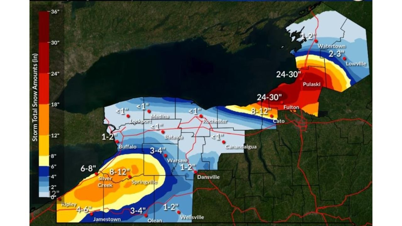
Intense Lake-Effect Band Expected to Lock Onto Oswego County
Meteorological guidance shows a well-defined lake-effect snow band forming off Lake Ontario and settling into a west-to-east orientation, placing the most persistent snowfall over central and eastern Oswego County, including areas near Fulton, Pulaski, and surrounding communities.
Unlike weaker, shifting lake-effect setups, this event is expected to remain organized for extended periods, allowing snow to accumulate rapidly in the same locations.
Snowfall Rates Could Reach 3 to 5 Inches Per Hour
Within the core of the band, snowfall rates are forecast to increase dramatically, with:
- 1 to 2 inches per hour possible early in the event
- 3 to 5 inches per hour during the most intense periods overnight and Friday
These rates are high enough to overwhelm plowing operations and cause roads to become impassable in a short time, even on major routes.
Forecast Snowfall Totals Signal High-Impact Event
Additional snowfall projections show:
- 24 to 30 inches possible in the most persistent band areas of Oswego County
- Sharp drop-offs outside the core band, meaning nearby locations could see far less snow while Oswego County bears the brunt of the storm
This sharp gradient is a hallmark of major lake-effect events and makes localized forecasting critical.
Travel Conditions Expected to Deteriorate Rapidly
With snowfall rates increasing and winds aligning with the lake-effect band, travel impacts are expected to become severe, especially:
- Overnight tonight
- During the Friday morning commute
- Into Friday evening if the band remains stationary
The National Weather Service explicitly warns that major travel impacts are possible in Oswego County, including near-zero visibility, snow-covered highways, and sudden whiteout conditions.
Lake Erie Snow Less Intense but Still Active
While the primary concern remains Lake Ontario, additional lake-effect snow off Lake Erie will redevelop across the western Southern Tier and far southern Erie County, producing:
- Periods of light to moderate snow
- Snowfall rates up to 1 to 2 inches per hour at times
However, impacts in those areas are expected to be significantly lower than in Oswego County.
What Residents Should Prepare For
Officials urge residents in Oswego County to:
- Avoid unnecessary travel during peak snowfall periods
- Prepare for rapidly changing conditions, even over short distances
- Monitor local alerts in case travel advisories or restrictions are issued
This is a classic high-impact lake-effect setup, where conditions can deteriorate far faster than typical winter storms.
Stay with WaldronNews.com for continued updates, radar analysis, and localized impact coverage as this dangerous lake-effect snow event unfolds across Oswego County and central New York.