
Lower Mississippi Valley and Mid-Atlantic Face Widespread 2 to 5 Inches of Rain Through Friday May 29 Bringing Critical Relief to Drought-Stricken Region
LOWER MISSISSIPPI VALLEY — A long-awaited rain event is taking shape across drought-stricken communities from the Lower Mississippi Valley to the Mid-Atlantic, with forecasters tracking widespread 2 to 5 inches of rainfall through Friday, May 29, 2026. This is the most significant moisture event in months for a region suffering under some of the worst drought conditions in the country.
How Bad Is the Drought Right Now
The U.S. Drought Monitor, released Thursday, May 21, 2026, and valid as of 8:00 AM EDT on Monday, May 19, 2026, confirms significant moisture deficits stretching from the Lower Mississippi Valley to the Mid-Atlantic. Drought categories range from D0 (Abnormally Dry) at the least severe end to D4 (Exceptional Drought) at the most extreme, and the latest map shows the region carrying some of the deepest deficits in the nation. These conditions mean soils are critically dry, water supplies are stressed and agricultural losses are already mounting.
What Each Drought Category Means for Residents
Drought is not just a farming problem. Here is what each level means for everyday life:
- D1 (Moderate Drought) means streams and reservoirs begin dropping below normal, wells may start to run low and outdoor water restrictions often begin at this stage.
- D2 (Severe Drought) means water shortages become common, crop and pasture losses grow significant and fire risk rises sharply across dry vegetation.
- D3 (Extreme Drought) means widespread water shortages affect homes and businesses, major crop losses occur and rivers can drop to critically low levels.
- D4 (Exceptional Drought) is the most severe category and signals an exceptional and widespread crisis, with water emergencies possible and some areas unable to meet basic water needs without outside help.
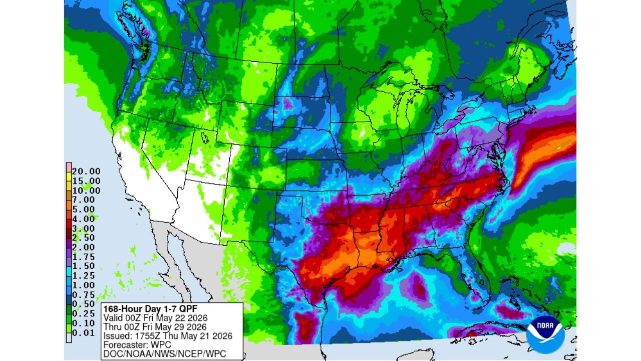
The 7-Day Rainfall Forecast: What Is Coming
The 168-hour rainfall forecast, issued at 5:55 PM EDT on Thursday, May 21, 2026, covers the period from Friday, May 22 through Friday, May 29, 2026. Forecasters are projecting widespread 2 to 5 inches of rainfall across the Lower Mississippi Valley and extending northeast toward the Mid-Atlantic. The forecast map shows the heaviest totals concentrated over the Lower Mississippi Valley, with meaningful amounts spreading across the broader region through the end of May 2026.
Will 2 to 5 Inches Be Enough to End the Drought
The short answer is: it depends on the category. Here is what 2 to 5 inches of rainfall can realistically do:
- A 2 to 5 inch rainfall event over 7 days can significantly relieve short-term drought (D0 and D1) by recharging shallow soil moisture and refilling smaller streams and ponds.
- Areas in D2 (Severe Drought) will see noticeable improvement, with crops and pastures beginning to recover within days of the rain falling across the Lower Mississippi Valley and surrounding areas.
- Communities in D3 and D4 drought will benefit from this rain event, but deeper water deficits that have been building for 6 or more months will require multiple rounds of above-normal rainfall over weeks or months to fully recover.
- The Mid-Atlantic portion of the region, which is also carrying notable moisture deficits based on the latest Drought Monitor, is expected to receive meaningful rainfall during this same 7-day window ending Friday, May 29, 2026.
Timing: When the Rain Arrives
The forecast period begins today, Friday, May 22, 2026, meaning the first rounds of rainfall are already possible across portions of the Lower Mississippi Valley and Mid-Atlantic as early as this afternoon or evening. Rain is expected to continue in waves through Friday, May 29, 2026, giving the region a full 7-day window to accumulate the projected 2 to 5 inches of much-needed moisture.
What Residents Should Know
This rainfall event is welcomed news for a region that has been running well below normal on precipitation. While 2 to 5 inches will not erase months of drought overnight, it marks a turning point and residents across the Lower Mississippi Valley and Mid-Atlantic should prepare for wet conditions through the end of May 2026. Localized flooding is always possible during heavy rain events, particularly in areas where dry, hardened soils cannot absorb water quickly, so residents should remain alert to any local warnings issued during this period.
WaldronNews.com will continue tracking this 2 to 5 inch rainfall event and drought relief conditions across the Lower Mississippi Valley and Mid-Atlantic and will provide updates as rainfall totals and drought monitor improvements develop.