
Midwest and Northeast Face Frost and Freeze Risk Into Early May as Well Below Average Temperatures Target Illinois, Indiana and Ohio Late This Month
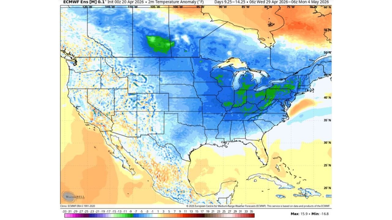
CHICAGO, Illinois — Enjoy the warmth while it lasts — a significant cold pattern is building for late April into early May, bringing well below average temperatures and a real frost and freeze risk across the Midwest and Northeast. Temperature anomaly forecasts valid April 29 through May 4 show a deep blue cold pool covering Illinois, Indiana, Ohio, Michigan, Wisconsin and surrounding states, with some areas running 8 to 16°F below normal.
The last time a May freeze hit was 2020 — and the atmospheric pattern now setting up is increasing confidence that May frosts are possible again this year.
States Facing the Late April Into Early May Cold
The cold pool covers a massive portion of the central and eastern US:
- Illinois: Chicago and central Illinois in the core of the below-normal temperature zone — 8 to 12°F below average in the April 29–May 4 window
- Indiana: Indianapolis corridor sitting deep in the cold anomaly zone
- Ohio: Columbus, Cleveland, and Cincinnati all under the cold pool
- Michigan: Detroit and Grand Rapids facing well below normal temperatures
- Wisconsin: Milwaukee and Madison included in the significant cold anomaly
- Pennsylvania and New York: Eastern fringe of the cold pattern with 3 to 8°F below normal readings
- Missouri and Iowa: Kansas City and Des Moines on the western edge of the cold zone
Primary Threats From the Late-Month Cold
This is not just a cool stretch — it carries real damage potential:
- Frost and freeze risk — temperatures running 8 to 16°F below normal in late April and early May bring overnight lows close to or below freezing across the Midwest and parts of the Northeast
- May freeze possible — the last May freeze occurred in 2020, and the current pattern increases confidence this could repeat in 2026
- Garden and crop damage — anyone who has planted warm-season vegetables or tender annuals in the last two weeks faces potential frost damage if temperatures drop to freezing
- Prolonged cold stretch — this is not a single cold night but a multi-day period of well below average temperatures driven by a dominant atmospheric pattern
Why This Cold Pattern Has High Confidence
Chicago, Illinois and the broader Midwest are about to experience a classic late-season cold shot driven by a large-scale atmospheric pattern shift. The NAO — North Atlantic Oscillation — is dropping sharply negative through late April, and when the NAO goes deeply negative, it allows cold Arctic air to push southward into the central and eastern United States rather than staying bottled up in Canada.
The NAO chart shows a clear, well-defined negative phase circled through the current period — the signal that confident forecasters have been watching for weeks. When this pattern dominates, chilly air bleeds eastward across the Midwest and into the Northeast, suppressing temperatures well below seasonal norms.
The temperature anomaly map confirms the story: a broad blue and green cold anomaly covering the entire Great Lakes region and extending east through Ohio, Indiana, and into Pennsylvania. The deepest cold — shown in green — is focused over Indiana, Ohio, and Michigan, where the below-normal signal is most pronounced.
What makes this setup particularly relevant for gardeners and farmers is the timing. Late April and early May is exactly when many Midwest residents plant their first warm-season crops — tomatoes, peppers, squash, and annual flowers. A frost event during this window can wipe out plants that were just getting established, especially if people assumed the last freeze of the season had already passed.
Before this cold arrives, temperatures are expected to rebound to above average for a period — giving a false sense that winter is fully over before the cold pattern reasserts itself.
Multi-Day Pattern
Now through late April — temperatures rebound to above normal. Enjoy the warm stretch. April 29 through May 4 — the cold pattern arrives, bringing well below average temperatures and frost/freeze potential across the Midwest and Northeast. Beyond May 4 — the NAO signal moderates, suggesting the cold pattern gradually relaxes, but confidence decreases at that extended range.
What to Watch Next
- Frost and freeze watches for Illinois, Indiana, Ohio, and Wisconsin in the April 29–May 4 window
- Overnight low temperature forecasts as the cold pattern locks in — whether readings drop to 32°F or below in major metro areas
- Garden and agricultural preparation guidance as the cold approaches
- Whether the cold anomaly deepens further as higher-resolution forecasts come into range
- The pattern after May 4 — whether above-normal temperatures return quickly or the cold lingers into mid-May
Residents across Illinois, Indiana, Ohio, Wisconsin, and Michigan should hold off on planting warm-season gardens until after the first week of May — and protect any plants already in the ground before the cold arrives late this month.
WaldronNews.com will continue tracking the late April cold pattern and frost risk and provide updates as the threat window approaches.