
New Hurricane Wind Gust Forecasting Tool Revealed Using Hurricane Milton Data Shows Tampa Bay Received Far Stronger Inland Gusts Than Sustained Wind Models Predicted
TAMPA, Florida — A significant advancement in hurricane wind forecasting is coming to operational use this summer, and data from Hurricane Milton’s 2024 landfall near Tampa Bay, Florida reveals exactly why the upgrade matters. A new wind gust parameterization tool, developed for the HAFS hurricane forecast system, shows that while standard 10-meter sustained wind forecasts dropped off rapidly once Milton moved inland, actual wind gusts extended hurricane-force conditions significantly deeper into the Tampa Bay area than the sustained wind model indicated. The difference between the two maps is not subtle, and it has direct implications for how residents in Florida and across the Gulf Coast prepare for future storms.
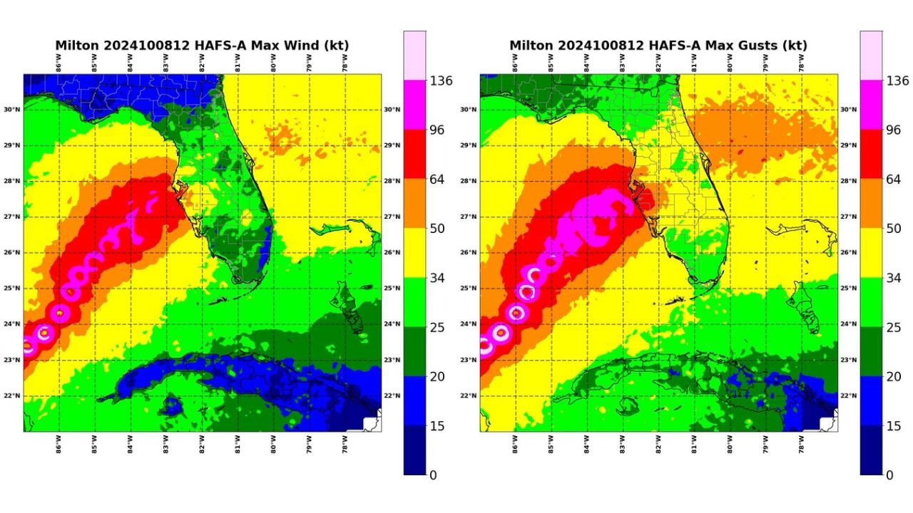
What the Two Maps Show
Comparing the sustained wind forecast against the maximum gust forecast for Hurricane Milton on October 8, 2024 makes the gap immediately visible.
Sustained Wind Map:
- Hurricane-force sustained winds concentrated tightly along the immediate coastline near Tampa Bay and the approach track from the Gulf of Mexico
- Winds drop sharply to 50 to 64 knots within a relatively short distance inland
- Most of central Florida sits in the 34 to 50 knot range, well below hurricane force
- Orlando and east-central Florida fall mostly in the 25 to 34 knot range on the sustained wind map
Maximum Gust Map:
- Hurricane-force gusts extend noticeably further inland across the Tampa Bay region and into central Florida
- The orange and red shading indicating 64 to 96 knot gusts covers a significantly broader area than the sustained wind map shows
- Central Florida sees gust values upgraded compared to the sustained wind depiction
- The difference is most pronounced in the Tampa Bay corridor, where gusts reached inland well beyond what the sustained wind map would suggest
Why This Gap Matters for Florida Residents
Sustained wind and wind gust are two different measurements that produce two very different damage profiles. Sustained winds are averaged over a period of time and represent the steady-state wind speed. Gusts are brief but violent spikes above the sustained wind, and they are responsible for a large share of tree failures, structural damage, roof losses and power outages during hurricanes.
When forecast models underestimate how far inland gusts will extend, residents in communities like Orlando, Lakeland and inland Tampa Bay suburbs may believe they are safely outside the worst wind zone when in reality they face hurricane-force gusts capable of significant damage.
The new gust parameterization tool specifically addresses this gap by more accurately capturing how gusts propagate inland from the storm core, a problem that has historically led to underprepared inland communities during Florida hurricane landfalls.
What This Means for the Upcoming Hurricane Season
This gust forecasting code is scheduled to be included in operational HAFS output this summer, meaning it will be available to forecasters before Atlantic hurricane season reaches its peak in August and September. For Florida Gulf Coast communities from Tampa Bay south through Fort Myers and Naples, which sit in the most statistically active landfall zone, this upgrade means future hurricane wind forecasts will more accurately communicate how far inland destructive gusts will reach rather than understating the inland threat through sustained wind values alone.
Residents across Tampa Bay, Orlando and central Florida who have previously dismissed inland wind threats during Gulf Coast hurricane landfalls should understand that gust impacts routinely extend much further from the coast than sustained wind forecasts suggest.
WaldronNews.com will continue tracking hurricane season developments and forecast modeling advancements affecting Florida and the Gulf Coast and will provide updated coverage as the 2026 Atlantic hurricane season approaches.