
New York, Pennsylvania and Vermont Face 60 mph Wind Gusts and 1 Inch Hail Wednesday May 13 From Elmira and Binghamton Through Syracuse, Albany and Burlington
SYRACUSE, New York — A line of strong to severe storms is sweeping through the Northeast United States on Wednesday, May 13, 2026, bringing damaging wind gusts up to 60 mph and large hail up to 1 inch in diameter across New York, Pennsylvania and Vermont from the afternoon hours through nearly midnight.
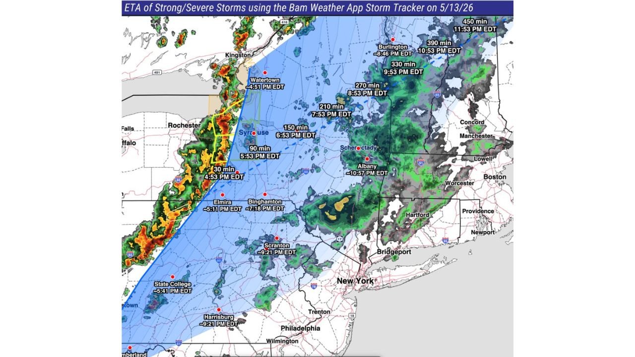
Storm arrival times have been precisely tracked for communities across the region. Here is exactly when the storms hit and what to expect.
Storm Arrival Times Wednesday May 13
| City | Arrival Time |
|---|---|
| Rochester area | 4:53 PM EDT (30 min mark) |
| Watertown, New York | 4:51 PM EDT |
| Elmira, New York | 5:11 PM EDT |
| Syracuse, New York | 5:53 PM EDT (90 min mark) |
| State College, Pennsylvania | 5:41 PM EDT |
| Binghamton, New York | 7:18 PM EDT |
| Syracuse area | 6:53 PM EDT (150 min mark) |
| Scranton, Pennsylvania | 9:21 PM EDT |
| Harrisburg, Pennsylvania | 9:21 PM EDT |
| Albany, New York | 10:57 PM EDT |
| Burlington, Vermont | 8:46 PM EDT |
| 390 min zone | 10:53 PM EDT |
| 450 min zone | 11:53 PM EDT |
The storm line is moving northeast at a significant pace, sweeping from western New York communities like Rochester before 5:00 PM EDT all the way through Burlington, Vermont and far northeastern New York approaching midnight.
Two Threats. One Line.
This is not a complex multi-storm outbreak. It is a single line of strong to severe storms producing two primary hazards as it sweeps northeast across New York, Pennsylvania and Vermont:
60 mph wind gusts are the bigger concern with this line. At 60 mph, gusts can snap tree branches, bring down power lines and cause scattered structural damage across communities from Elmira and Binghamton through Syracuse, Albany and Burlington. Power outages are likely along the storm track Wednesday evening and night.
1 inch hail is possible with the stronger cells embedded within the line. One inch hail, roughly the size of a quarter, can dent vehicles and damage roofing and siding but is generally less destructive than the golf-ball-plus sizes associated with Plains supercell events.
Western New York Gets It First
Rochester is essentially already in it at the time of this report with a 30-minute arrival marker at 4:53 PM EDT. Watertown and Elmira follow within the next 20 minutes. Residents in these communities should be sheltered now.
Syracuse residents have until approximately 5:53 PM EDT before the main line arrives, with State College, Pennsylvania seeing storms around 5:41 PM EDT.
The Long Night for Eastern Communities
While western New York deals with storms during the late afternoon commute hours, the storm line does not reach eastern communities until much later. Albany will not see storms until approximately 10:57 PM EDT. Burlington, Vermont is tracking 8:46 PM EDT. Communities near Scranton and Harrisburg, Pennsylvania are both tracking 9:21 PM EDT arrivals.
This means residents in Albany, Burlington and Harrisburg have several more hours to prepare but should keep weather alerts active through the full evening and not assume they are in the clear simply because afternoon hours pass without storms.
WaldronNews.com will continue tracking this severe storm line across New York, Pennsylvania and Vermont including Syracuse, Binghamton, Albany, Burlington and Harrisburg and will provide updates as 60 mph wind gusts, hail reports and power outage information develop through Wednesday, May 13 night.