
Kansas Faces 2 Inch Hail and Sporadic Damaging Gusts From Rotating Supercells Near Salina, Emporia, Wichita and Topeka Thursday May 14 With Tornado Possible if Storms Survive Into Evening
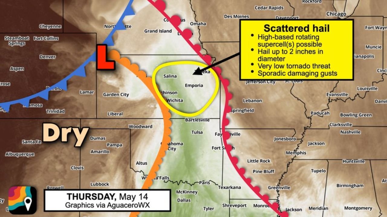
WICHITA, Kansas — High-based rotating supercells are expected to fire across Kansas on Thursday, May 14, 2026, targeting a concentrated zone from Salina and Emporia southward through Wichita and Topeka, with hail up to 2 inches in diameter and sporadic damaging gusts as the primary threats during the afternoon hours.
The tornado threat is very low during the afternoon but increases if any storms survive into the evening as moisture arrives late to the region.
The Setup in Plain Terms
Thursday’s moisture across Kansas will be a bit late arriving, and that timing problem is actually what shapes the entire storm threat for the day. Here is how it breaks down hour by hour:
Afternoon phase storms fire as high-based supercells along the dryline shown running through central Kansas on the Thursday, May 14 setup map. High-based means the cloud bases are higher off the ground than typical supercells because the low-level air is still relatively dry. These storms rotate as supercells and will produce scattered large hail as their primary threat. The tornado threat during this phase is very low given the dry surface air limiting low-level rotation.
Evening phase is where the wild card enters. If any of these supercells survive into the evening hours, increasing moisture arriving late to Kansas might allow a tornado or two. This is not the primary forecast but it is a scenario residents near Wichita, Emporia and Topeka need to be aware of heading into Thursday night.
Threat Summary for Thursday May 14
| Threat | Level | Details |
|---|---|---|
| Hail | Primary | Up to 2 inches diameter possible |
| Wind Gusts | Secondary | Sporadic damaging gusts with supercells |
| Tornado | Very Low afternoon | Increases slightly if storms survive to evening |
| Storm Type | High-based supercells | Rotating storms along the Kansas dryline |
Cities in the Risk Zone
The yellow circled area on the Thursday, May 14 storm outlook map covers the concentrated risk zone across central Kansas:
Salina sits on the northern edge of the circled zone. Emporia falls near the center. Wichita is within the southern portion of the outlined risk area. Topeka sits on the northeastern edge where storms pushing northeast along the dryline could arrive during the afternoon or early evening hours. Garden City and Liberal to the west are currently in the dry zone and sit outside the primary risk area for Thursday.
What 2 Inch Hail Looks Like
Two inch hail is roughly the size of a golf ball to a pool ball and falls fast enough to cause serious damage very quickly. Vehicle roofs, windshields and hoods are highly vulnerable. Roofing materials, siding and gutters can be damaged in under a minute of active hailfall. Move all vehicles into covered shelter before storms develop Thursday afternoon if you are anywhere near Salina, Emporia, Wichita or Topeka.
Thursday Evening Watch
The key time to watch on Thursday, May 14 is the transition from afternoon into evening. If supercells that fired during the afternoon stay alive as moisture increases across Kansas, the tornado risk ticks upward from very low to low across the Wichita to Topeka corridor. Keep weather alerts active through Thursday night and not just during the afternoon storm window.
WaldronNews.com will continue tracking high-based supercell development, 2 inch hail and the evening tornado risk across Kansas including Salina, Emporia, Wichita and Topeka and will provide updates as storm timing and moisture arrival details develop through Thursday, May 14.