
North Carolina and South Carolina Drought Deepens as Charlotte Needs 15.37 Inches and Asheville 15.04 Inches in One Month While Tonight Brings Less Than 0.50 Inches After Nearly 3 Months
CHARLOTTE, North Carolina — The most rainfall in nearly three months is possible tonight into early Thursday across the Carolinas, but even the best-case totals will not come close to ending the drought gripping the region. Anything above 0.50 inches would be more than the area has seen in almost two months, yet ending the drought entirely would require 10 to 15 inches of rain falling within a single month across much of North Carolina and South Carolina.
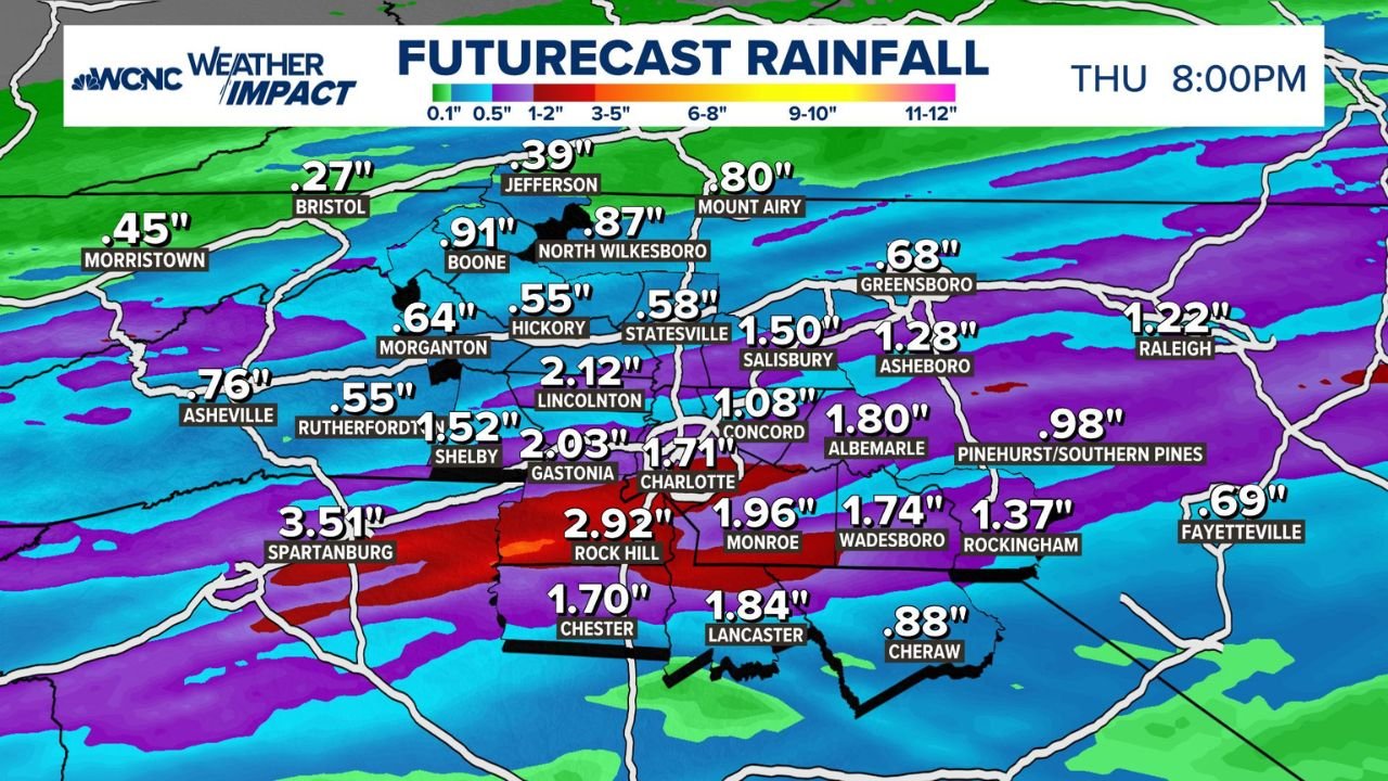
What Tonight’s Rain Actually Delivers
Futurecast rainfall totals valid through Thursday 8 PM show the heaviest totals focused on the Charlotte metro and surrounding counties:
- Rock Hill, South Carolina: 2.92 inches
- Spartanburg, South Carolina: 3.51 inches
- Gastonia, North Carolina: 2.03 inches
- Charlotte, North Carolina: 1.71 inches
- Monroe, North Carolina: 1.96 inches
- Lincolnton, North Carolina: 2.12 inches
- Salisbury, North Carolina: 1.50 inches
- Concord, North Carolina: 1.08 inches
- Albemarle, North Carolina: 1.80 inches
- Wadesboro, North Carolina: 1.74 inches
- Lancaster, South Carolina: 1.84 inches
- Chester, South Carolina: 1.70 inches
- Asheville, North Carolina: 0.76 inches
- Morganton, North Carolina: 0.64 inches
- Boone, North Carolina: 0.91 inches
- Raleigh, North Carolina: 1.22 inches
- Greensboro, North Carolina: 0.68 inches
- Fayetteville, North Carolina: 0.69 inches
What It Would Actually Take to End the Drought
One month of rainfall required to break the drought across the Carolinas by zone:
- Charlotte and Monroe corridor: 15.37 inches
- Asheville: 15.04 inches
- Greenville, South Carolina area: 14.40 inches
- Greensboro and Triad region: 13.97 inches
- Boone: 12.29 inches
- Chester and Lancaster, South Carolina: 11.60 inches
- Rockingham and Southern Pines: 10.64 inches
- Cheraw: 8.91 inches
- Raleigh corridor: 9.95 inches
Tonight’s best-case totals in the Charlotte area reach roughly 2.92 inches at Rock Hill and 3.51 inches at Spartanburg. Against a drought-ending threshold of 15.37 inches for Charlotte in one month, tonight’s rain covers approximately 20 percent of what is needed and nothing more.
Why This Rain Matters Despite Falling Short
Any rainfall after nearly three months of near-zero precipitation provides measurable relief for topsoil moisture, fire danger reduction and municipal reservoir levels. The 0.50 inch threshold being discussed as meaningful context reflects just how dry the region has become. A storm delivering 2 to 3 inches in the heaviest zones is a genuine short-term benefit even while the underlying drought deficit remains essentially unchanged.
What to Watch Through Thursday
- Tonight into early Thursday is the primary window for the heaviest totals across the Charlotte metro, Rock Hill and Spartanburg
- Runoff rates will be elevated because drought-hardened soil absorbs water slowly, meaning localized flooding is possible even from rainfall amounts that would normally pose no risk
- Drought status will not change from tonight’s event alone — the 10 to 15 inch monthly requirement remains the benchmark for any meaningful drought recovery
- Fire danger will temporarily decrease across western North Carolina and upstate South Carolina as surface moisture increases
- Monitor for additional rain chances through the remainder of the week as the pattern that brought tonight’s system may allow for follow-up opportunities
WaldronNews.com will continue tracking rainfall totals and drought conditions across North Carolina and South Carolina and will provide updates as Thursday’s totals are confirmed.