
Severe Storms Target Minnesota, Wisconsin, Texas and Oklahoma Monday With 2 Inch Hail and Tornadoes Possible From Minneapolis and Chicago to Dallas and Oklahoma City
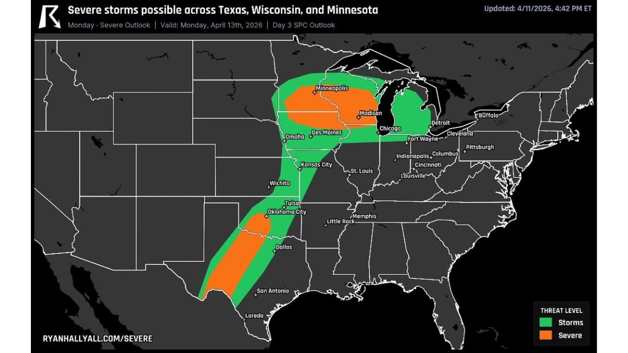
CHICAGO, Illinois — A sprawling and dangerous severe weather outbreak is taking shape for Monday, April 13, with two distinct and separate severe storm corridors threatening millions of Americans from the Upper Mississippi Valley and Great Lakes down through the Southern Plains — putting cities including Minneapolis, Milwaukee, Madison, Chicago, Oklahoma City, and Dallas all in the path of significant storm threats, according to the Day 3 SPC Outlook updated by Ryan Hall Y’all on April 11, 2026.
The setup features two separate risk zones — one across the Upper Midwest where very large hail is the primary threat near the warm front, and one across the Southern Plains where a conditional but potentially explosive supercell outbreak could produce damaging winds, enormous hail, and tornadoes if storms manage to break the cap along the dryline.
Cities and States Facing Severe Weather Monday
- Minnesota: Minneapolis sits directly inside the Enhanced severe risk zone — one of the highest threat areas in Monday’s outlook
- Wisconsin: Milwaukee and Madison are inside the Enhanced severe corridor where very large hail and damaging winds are most likely
- Illinois: Chicago falls within the severe threat zone as the storm system sweeps east through the Great Lakes region
- Iowa: Des Moines and Omaha sit along the severe risk boundary between the two threat corridors
- Oklahoma: Oklahoma City and Tulsa are inside the Enhanced severe zone on the Southern Plains end of Monday’s threat
- Texas: Dallas and San Antonio sit within the Southern Plains severe corridor — conditional on cap break but capable of producing violent supercells if storms fire
- Missouri: Kansas City and St. Louis fall within the broader storm threat zone connecting the two risk areas
Two Separate Threats — Both Dangerous
Upper Midwest Threat — Minnesota, Wisconsin, Illinois:
The Upper Midwest setup is driven by a warm front pushing through Iowa, Minnesota, and Wisconsin, creating a focused zone near the front where atmospheric instability and wind shear combine to support large to very large hail of 2 inches or greater in diameter. Two-inch hail is the size of a baseball — capable of destroying crops, shattering vehicle windshields, and causing significant property damage across the Minneapolis, Milwaukee, and Madison metros. Damaging winds are also a concern with any storms that develop along and north of the warm front boundary across Iowa, Minnesota, and Wisconsin.
Southern Plains Threat — Oklahoma, Texas:
Further south, the threat is conditional but potentially more violent if it verifies. A dryline — the boundary between hot, dry air from the west and warm, moist air from the Gulf — is the trigger mechanism for the Southern Plains setup. If storms can break through the atmospheric cap along this boundary Monday afternoon, supercells with very large hail, damaging winds, and a couple of tornadoes become possible across the Oklahoma City, Tulsa, and Dallas corridor. The conditional nature of this threat means it could either remain suppressed or explode into a significant outbreak depending entirely on how aggressively storms can break the cap.
Why Residents From Minneapolis to Dallas Need to Pay Attention
Monday’s storm system is unusual in its geographic reach. It is rare for a single severe weather outbreak to simultaneously threaten communities as far apart as Minneapolis, Minnesota and San Antonio, Texas — yet that is exactly what Monday’s setup is delivering. The same large-scale atmospheric pattern driving dangerous warm front dynamics across the Great Lakes is also fueling the dryline setup that could ignite supercells across Oklahoma and Texas.
For residents in Minneapolis, Milwaukee, and Madison, the primary action to take is protecting vehicles and property from potentially baseball-sized hail. For residents in Oklahoma City, Dallas, and Tulsa, the concern extends to tornadoes — and the conditional nature of the Southern Plains threat should not breed complacency. When the cap breaks on a loaded Southern Plains atmosphere, storms can develop and become severe within minutes.
Multi-Day Pattern
Monday’s severe weather event arrives as the third in a back-to-back-to-back severe weather sequence that began with Saturday’s tornado outbreak across Nebraska and Kansas, continued with Sunday’s conditional severe threat across Texas and Oklahoma, and now culminates with Monday’s dual-corridor threat from the Great Lakes to the Southern Plains. The atmosphere has been cycling through dangerous setups repeatedly, and residents across the central United States should be treating this entire stretch from Saturday through Monday as a period of sustained elevated severe weather risk.
What to Watch Monday
- Residents in Minneapolis, Milwaukee, and Madison should secure vehicles indoors or under cover before Monday afternoon — 2 inch plus hail can total a car in minutes
- Oklahoma City, Tulsa, and Dallas residents should monitor cap break timing Monday afternoon — if storms fire along the dryline, tornado warnings could follow quickly
- Watch for SPC to upgrade Monday’s outlook as the event gets closer and model confidence increases — the current Day 3 outlook may not reflect the full threat
- Chicago and Des Moines sit on the boundary between the two risk corridors and should monitor both the warm front timing and any southward expansion of the severe threat
- Anyone with outdoor plans across Minnesota, Wisconsin, Iowa, Oklahoma, or Texas Monday should have a backup plan and weather alerts active all day
- Monitor NWS Minneapolis, NWS Chicago, NWS Norman, and NWS Fort Worth local forecast offices for real-time watch and warning issuance Monday
From Minneapolis to Dallas, Monday is a day to take seriously. The atmosphere is loaded, two separate severe corridors are in play, and the window to prepare is now.
WaldronNews.com will continue tracking Monday’s severe weather outbreak across Minnesota, Wisconsin, Illinois, Oklahoma, and Texas and will provide updates as the SPC outlook is refined and storm details become clearer.