
Storm Prediction Center Upgrades Tornado Risk for Southeast Nebraska and Northeast Kansas With EF2 Strong Tornado Possible From Grand Island and Lincoln Through Topeka and Salina Today
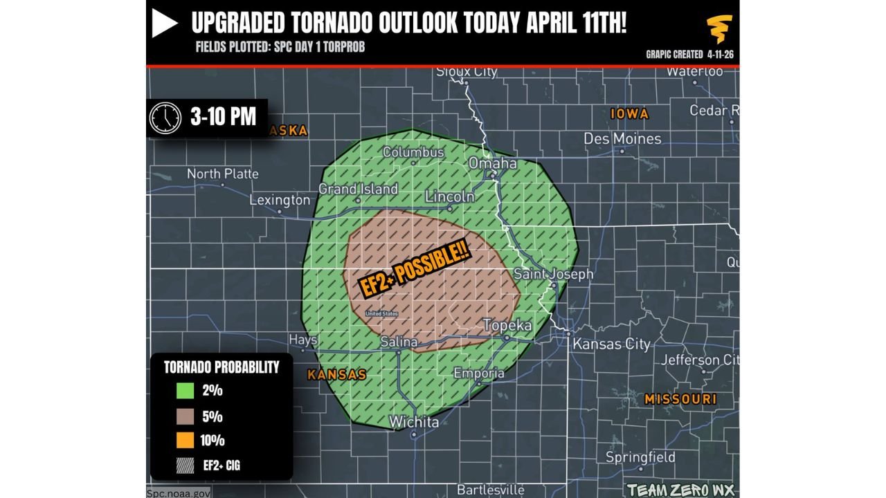
KANSAS CITY, Missouri — The Storm Prediction Center has just issued an upgraded tornado outlook for Saturday, April 11, raising the tornado probability across a corridor from southeast Nebraska into northeast Kansas to a 5% hatched tornado risk — a designation that signals increasing forecaster confidence in a volatile, supercell-supporting environment capable of producing a couple of tornadoes, including a strong EF2 or greater tornado, during the critical window of 3:00 PM to 10:00 PM CDT today.
The upgrade comes as confidence grows that storms will actually initiate across the region, combined with a more dangerous atmospheric environment developing along the warm front than previously anticipated, according to the Storm Prediction Center (SPC/NOAA).
Cities and States in the Risk Zone
- Nebraska: Grand Island, Lincoln, Omaha, Columbus, and North Platte sit within the tornado risk zone — Lincoln and Grand Island are inside the higher 5% hatched area where EF2+ potential is greatest
- Kansas: Topeka, Salina, Emporia, Wichita, and the broader northeast Kansas corridor fall directly inside the upgraded risk zone — Topeka and Salina sit inside the core EF2+ possible area
- Missouri: Kansas City, St. Joseph, and Jefferson City sit on the eastern edge of the broader tornado risk corridor
- Iowa: Des Moines and southern Iowa communities fall within the outer 2% tornado probability zone
Primary Threats
The SPC upgrade carries specific and serious implications for residents across the risk zone this afternoon and evening:
- EF2+ strong tornado possible — The hatched zone covering the Grand Island to Lincoln to Topeka corridor explicitly flags the potential for a significant, violent tornado rated EF2 or stronger. This is not a routine severe weather designation — hatched tornado areas are issued only when forecasters have meaningful confidence in strong tornado production
- Multiple tornadoes expected — If a supercell can be maintained across the warm front environment, a couple of tornadoes are possible during the 3 PM to 10 PM CDT window — meaning this is not a single brief spin-up scenario but potentially an extended, multi-tornado threat
- Volatile warm front environment — The upgrade was triggered specifically by increasing confidence in a more volatile environment along the warm front — this boundary is where atmospheric wind shear and moisture interact most aggressively, creating ideal conditions for rotating supercells
- High storm initiation confidence — Unlike earlier in the day when storm development was uncertain, forecasters now have higher confidence that storms will actually fire across the upgraded area, making the threat more imminent and real than a conditional or speculative risk
Why This Matters for Nebraska and Kansas
An SPC upgrade mid-day on an active severe weather day is one of the most serious signals forecasters can send to the public. It means the atmosphere is trending more dangerous in real time, not less — and that the window to prepare is narrowing rapidly.
The 5% hatched tornado probability covering the Grand Island, Lincoln, Salina, and Topeka corridor is the specific detail that demands immediate attention. The hatching designation — marked clearly on the Team Zero WX graphic as “EF2+ POSSIBLE!!” — means forecasters are confident enough in the environment to warn explicitly about violent tornado potential. An EF2 tornado carries winds of 111 to 135 mph and can destroy well-constructed homes, snap large trees, and overturn vehicles. An EF3 or higher is catastrophic.
Residents in Lincoln, Grand Island, Topeka, and Salina are in the direct path of today’s most dangerous tornado corridor. The threat window opens at 3:00 PM CDT — which for many communities is right in the middle of afternoon school dismissal, evening commutes, and outdoor activities. Anyone in the hatched zone needs to be inside a sturdy shelter and weather-aware before 3 PM arrives.
Multi-Day Pattern
Saturday’s upgraded tornado threat is the first in a multi-day severe weather sequence across the central United States. Sunday, April 12 brings a separate conditional severe weather setup across the Texas, Oklahoma, and Kansas corridor from San Antonio to Wichita. Monday, April 13 then follows with another organized severe weather threat targeting the broader Midwest. This is not a one-day event — residents across Nebraska, Kansas, and surrounding states are entering an extended period of dangerous weather that demands sustained attention through the early part of next week.
What to Watch Next
- The 3 PM CDT window is the start of the danger period — be sheltered, weather-aware, and away from mobile homes and vehicles before this time if you are in the hatched zone
- Residents in Grand Island, Lincoln, Omaha, Topeka, Salina, and Kansas City should have multiple ways to receive tornado warnings — weather radio, phone alerts, and a trusted weather app all active simultaneously
- Watch for tornado watches from the SPC to be issued imminently covering Nebraska and Kansas — a watch means conditions are favorable; a warning means a tornado has been confirmed or detected on radar and you must seek shelter immediately
- The warm front position will determine exactly where the strongest storms track this afternoon — communities along and just north of the front carry the highest risk
- Do not wait for a tornado warning to begin moving to your shelter if you are in the EF2+ hatched zone — by the time a warning is issued, you may have only minutes to act
- Monitor NWS Omaha and NWS Topeka local forecast offices throughout the afternoon for real-time warning issuance and storm updates
The Storm Prediction Center has spoken clearly — the tornado threat across southeast Nebraska and northeast Kansas is real, it is upgraded, and the dangerous window begins this afternoon. Residents across Grand Island, Lincoln, Topeka, Salina, and the Kansas City metro are urged to treat this as an immediate threat, shelter before 3 PM, and have multiple warning systems active and ready.
WaldronNews.com will continue tracking this upgraded tornado threat across Nebraska and Kansas throughout Saturday afternoon and evening and will provide updates as watches, warnings, and storm reports become available.