
Texas Faces Destructive Tornadic Storms North of San Angelo With 70 mph Wind Gusts and Very Large Hail Monday May 11 This Evening
SAN ANGELO, Texas — Destructive, tornadic storms are ongoing right now in Central Texas, just north of San Angelo, bringing extremely dangerous conditions including radar-indicated 70 mph wind gusts, very large hail and active tornadic activity this evening, Monday, May 11, 2026.
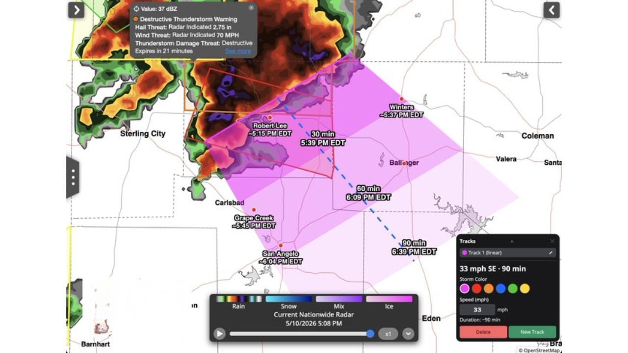
A Destructive Thunderstorm Warning is currently in effect, and residents in the affected areas must take shelter immediately.
Active Warning Details
A Destructive Thunderstorm Warning is in effect for the storms moving through Central Texas north of San Angelo:
- Radar has indicated wind gusts up to 70 mph with this storm, strong enough to down large trees, snap power lines and cause significant structural damage to homes and buildings.
- Hail threat is rated as very large with this system, capable of breaking windows, destroying vehicles and damaging roofs within minutes.
- Tornadic activity is ongoing with these storms, meaning a tornado may be producing damage right now north of San Angelo.
Storm Timing and Movement
Storm Tracker data shows the following timing for communities north of San Angelo:
- Ballinger is tracking a storm arrival at 5:59 PM EDT with a second storm at 5:59 PM EDT.
- Green Creek is tracking storm arrival at 4:45 PM EDT.
- Winters is tracking storm arrival at 4:15 PM EDT with a follow-up at 6:15 PM EDT.
- Storm movement is tracking at 33 mph to the southeast with arrival estimates within 90 minutes for communities in the storm path.
What To Do Right Now
If you live north of San Angelo or anywhere in Central Texas within this warning zone, do not wait:
- Move to an interior room on the lowest floor of a sturdy building immediately, away from all windows.
- Do not attempt to outrun this storm in a vehicle. At 33 mph storm movement, conditions can change faster than you can drive to safety on rural Texas roads.
- Stay sheltered until the Destructive Thunderstorm Warning expires and local authorities confirm it is safe to go outside.
Ongoing Threat This Evening
Destructive wind gusts, very large hail and tornadic activity remain the primary threats across Central Texas north of San Angelo through this evening. The storm is currently rated at 37 dBZ reflectivity values and remains an extremely dangerous situation.
Residents in Sterling City, Carlsbad, Ballinger, Winters and Coleman should remain on high alert through the evening hours as additional storms may follow the initial line.
WaldronNews.com will continue tracking these destructive tornadic storms across Central Texas north of San Angelo and will provide updates as wind gust speeds, hail reports and tornado activity develop through this evening Monday, May 11.