
Texas, Oklahoma and Louisiana Face Damaging Winds and Large Hail Sunday as Dallas and Shreveport Sit Inside the Enhanced Risk Zone With Tornado Possible Near London
DALLAS, Texas — A large severe weather risk is in place for Sunday May 10, 2026 across Texas, Oklahoma and Louisiana, with Dallas and Shreveport sitting inside the Enhanced Risk zone — the highest category on this outlook. Damaging winds and large hail are the primary concerns across the risk area, with a tornado risk specifically noted near London as the most localized significant threat of the day.
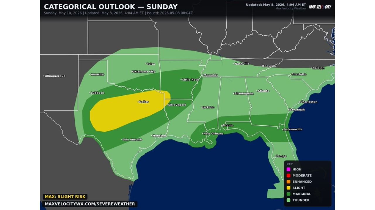
Risk Zones for Sunday May 10
- Enhanced Risk — Slight Risk level max: Dallas and Shreveport corridor — yellow zone covering north Texas through northwest Louisiana and southern Arkansas, the area facing the highest concentration of damaging wind and large hail potential
- Slight Risk: Broader zone covering Oklahoma City, Tulsa, Little Rock, Memphis and Jackson — elevated severe weather potential across the central and lower Mississippi Valley
- Marginal Risk: Outer coverage reaching Amarillo, Lubbock, San Antonio, Houston, New Orleans, Mobile, Birmingham and Nashville
- General Thunder: Extended coverage across the full Southeast from Tampa through Jacksonville, Savannah, Charlotte and Raleigh
Primary Threats Sunday
- Damaging winds — the dominant hazard across the entire risk area from Texas through Louisiana and Arkansas
- Large hail — co-equal threat with winds across the Enhanced and Slight Risk zones
- Tornado near London — a localized tornado risk is specifically flagged, making this the most targeted severe hazard of the day for that area
What Dallas and Shreveport Residents Must Do Sunday
- Have weather alerts active before storms arrive — damaging winds and large hail can accompany storms that develop quickly along the frontal boundary
- Secure any outdoor furniture, patio items or unsecured objects before Sunday afternoon — damaging wind gusts can down trees and cause significant property damage
- Large hail threatens vehicles and roofs — move vehicles to covered parking if possible ahead of the main storm threat window
- London area residents face the most specific tornado concern of the day — shelter plans should be confirmed before storms arrive
- Monitor radar through Sunday afternoon and evening as the frontal boundary pushes through the region
WaldronNews.com will continue tracking Sunday’s severe weather threat across Texas, Oklahoma and Louisiana and will provide updates as storms develop and any warnings are issued.