
Tuesday Emerges as the Most Dangerous Day of the Week Across the Southern Plains as Explosive Instability and a Sharp Storm Boundary Put Kansas and Oklahoma on High Alert
KANSAS CITY, Missouri — Veteran storm chasers and atmospheric scientists are zeroing in on Tuesday, April 14 as the single most potent and dangerous severe weather setup of the entire multi-day outbreak sequence currently unfolding across the central United States — with the NAM model painting a striking and deeply concerning picture of atmospheric conditions across the Southern Plains that demands serious attention from residents across the region.
The NAM model data shows an extraordinary combination of extreme instability, a sharp atmospheric boundary, and significant upper-level energy converging over the Southern Plains on Tuesday — and while two specific meteorological concerns are giving forecasters pause, the overall setup is being described as the most powerful of the entire upcoming stretch.
What the NAM Model Is Showing
The NAM model analysis for Tuesday reveals several alarming atmospheric signals that collectively make this the standout setup of the week:
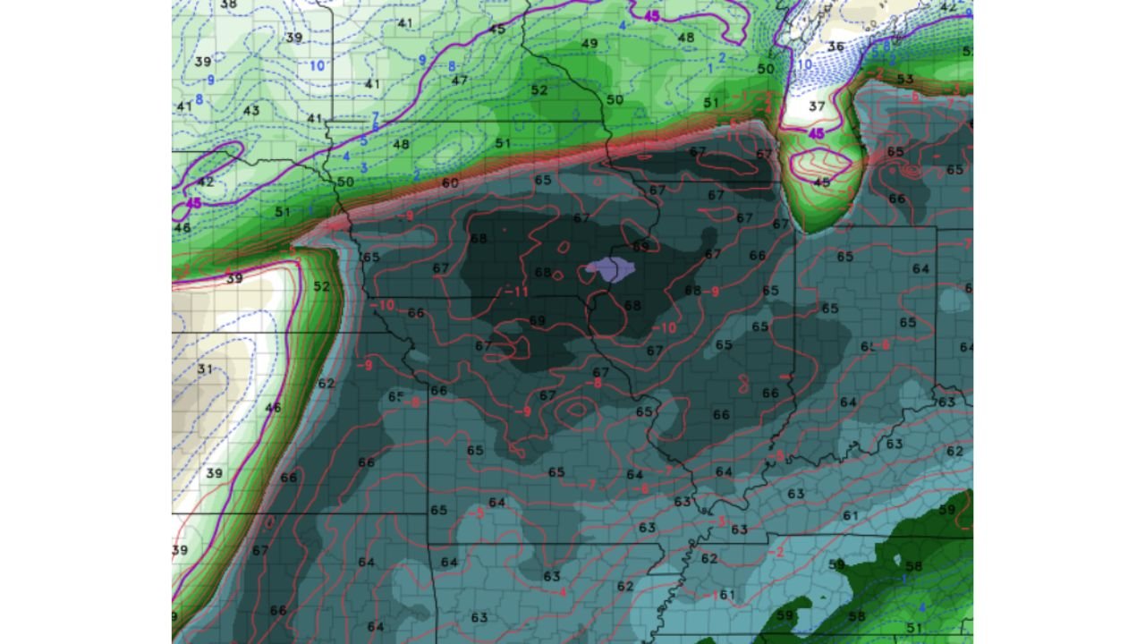
Deep Surface Moisture and Instability — The dark shading dominating the central portion of the map represents an enormous pool of deeply unstable air sitting across the Southern Plains on Tuesday. Dewpoint values in the mid to upper 60s°F are shown across a broad area, indicating rich, deep Gulf moisture streaming into the region. This is the fuel that powers explosive thunderstorm development — and the coverage and depth of this moisture pool is exceptional even by Southern Plains standards.
Sharp Atmospheric Boundary — The bold red and pink line slashing diagonally across the map from southwest to northeast is a critical surface boundary — likely a dryline or warm front — that will serve as the primary trigger mechanism for Tuesday’s storms. Where this boundary sits determines exactly where the most dangerous storms fire, and its position directly over the heart of the Southern Plains puts the most populated corridors of Kansas, Oklahoma, and the surrounding region directly in the crosshairs.
Upper-Level Trough Energy — The green and teal shading across the northern portion of the map represents significant 500mb upper-level trough energy pushing into the region from the northwest. This upper-level support is what takes a loaded surface environment and turns it into an organized, long-lived severe weather outbreak.
The Two Forecaster Concerns
Despite the powerful setup, two specific atmospheric factors are giving meteorologists reason to temper expectations slightly — though neither eliminates the threat:
De-amplifying 500mb Trough — The upper-level trough driving Tuesday’s system is showing signs of losing amplitude — meaning it is flattening out rather than deepening as it approaches. A stronger, more amplified trough would provide more aggressive upper-level support for storm organization and could dramatically increase the tornado threat. A weakening trough reduces but does not eliminate this support.
Grossly Veered 850mb Winds — Wind direction at the 850 millibar level — roughly 5,000 feet above the surface — is showing significant veering, meaning winds are turning clockwise in a way that slightly reduces the low-level wind shear that rotating supercells need to produce tornadoes. However, forecasters note this can still work in this region — the Southern Plains atmosphere is capable of producing dangerous supercells even when 850mb winds are not perfectly configured.
Why Tuesday Stands Above the Rest of the Week
What makes Tuesday’s setup uniquely dangerous compared to the Saturday, Sunday, and Monday events already in this sequence is the sheer concentration of atmospheric energy in one location at one time. The NAM model’s depiction of surface dewpoints in the mid-to-upper 60s across a wide area, combined with a sharp triggering boundary and upper-level support, represents the kind of environment where all severe weather hazards — large hail, damaging winds, and tornadoes — become simultaneously possible across the same corridor.
The purple shading visible near the center of the map represents the absolute core of the instability pool — an area where atmospheric energy is so concentrated it registers separately from the surrounding already-extreme environment. When forecasters see this level of surface moisture and instability beneath an approaching upper trough with a sharp boundary in place, Tuesday is not a day to take lightly regardless of the limiting factors.
Forecasters are explicitly calling this the most potent looking setup of the upcoming stretch — and that assessment covers a week that has already included a tornado outbreak in Nebraska and Kansas, a Southern Plains severe threat, and a major Great Lakes severe event.
Multi-Day Context
Tuesday closes out what has been one of the most active and sustained severe weather stretches across the central United States in recent memory. Saturday produced tornado-warned supercells across Nebraska and Kansas. Sunday brought conditional severe weather to Texas and Oklahoma. Monday targets Minnesota, Wisconsin, and the Great Lakes. And Tuesday now emerges as the capstone event — the day that models are flagging as the most atmospherically loaded of the entire sequence.
Residents across the Southern Plains who may be experiencing severe weather fatigue after days of elevated threats are urged not to let their guard down for Tuesday. Fatigue does not reduce atmospheric energy — and the NAM model is showing more of it on Tuesday than any other day this week.
What to Watch Heading Into Tuesday
- Watch for SPC Day 2 and Day 1 outlooks to be upgraded for the Southern Plains as Tuesday approaches and NAM model signals are confirmed or adjusted by other models
- The position of the surface boundary shown on the NAM map will be the single most important factor in determining exactly where Tuesday’s most dangerous storms develop
- Monitor whether the 500mb trough de-amplification trend continues or reverses — if the trough strengthens rather than weakens, Tuesday’s threat level increases significantly
- 850mb wind veer should be reassessed in Monday morning model runs — any improvement in low-level shear would dramatically raise the tornado potential for Tuesday
- Storm chasers and professional meteorologists are already positioning for Tuesday — residents across the Southern Plains should treat this level of professional attention as a serious signal
- Have multiple warning systems active all day Tuesday — watches and warnings may come with shorter lead times if storm mode trends toward fast-moving organized systems
Tuesday is shaping up as the week’s defining severe weather day across the Southern Plains. The atmosphere is loaded with exceptional instability, a sharp trigger boundary is in place, and upper-level support is present despite some weakening. Residents across Kansas, Oklahoma, and the surrounding Southern Plains are urged to stay weather-aware, monitor forecast updates closely Monday and Tuesday morning, and be prepared to act the moment watches or warnings are issued.
WaldronNews.com will continue tracking Tuesday’s severe weather potential across the Southern Plains and will provide updates as model data and SPC outlooks are refined heading into the event.