
Violent Tornadoes and Large Hail Threatening Brookhaven, McComb and Hattiesburg as Dangerous Storms Move Through Southwest Mississippi Wednesday Evening
JACKSON, Mississippi — A potent severe weather environment is in place across southwest Mississippi and the southern fringe of Dixie Alley, with strong divergence and difluence at 300 mb, the nose of the 850 mb jet positioned directly over the threat area, and surface-based CAPE values running at 2,000 to 2,500 joules per kilogram across the core zone. The combination is producing very dangerous supercells capable of violent tornadoes, large hail and damaging winds.
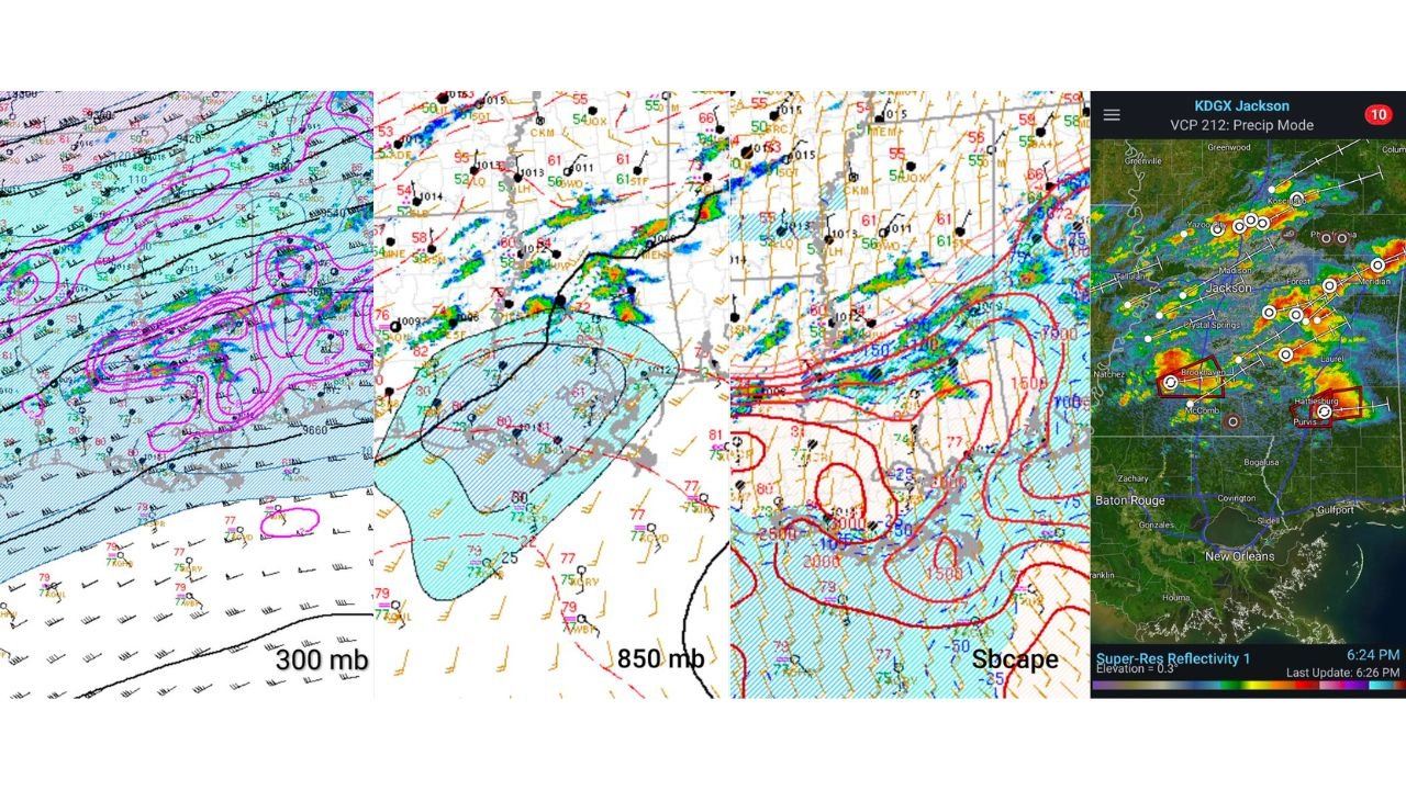
What the Upper Atmosphere Is Showing
300 mb analysis reveals the key ingredients driving this event:
- Strong divergence and difluence at 300 mb positioned directly over the Mississippi corridor — divergence at this level acts as an exhaust fan for thunderstorm updrafts, allowing storms to grow explosively and sustain rotation
- Wind speeds at 300 mb running at 100 to 110 knots across the threat corridor
- Upper-level support is as favorable as it gets for supercell maintenance and intensification
850 mb analysis shows:
- Nose of the 850 mb jet sitting directly over the southwest Mississippi and southern Dixie Alley region — the low-level jet is the primary driver of low-level wind shear and storm-relative helicity that produces tornado-capable rotation
- The hatched blue zone of instability centered over Mississippi with dewpoints running at 75 to 80 degrees across the core
- Surface low pressure and frontal boundaries clearly defined across the region
Surface-Based CAPE Across the Threat Zone
SBCAPE values from the surface analysis:
- 2,500 J/kg across the southwest Mississippi core centered near the Brookhaven and McComb corridor
- 2,000 J/kg extending across the broader Jackson southward zone
- 1,500 J/kg on the eastern fringe reaching toward Hattiesburg and Purvis
- Values drop sharply north of Jackson where the instability gradient cuts off the most dangerous environment
Surface-based CAPE of 2,000 to 2,500 J/kg combined with the 850 mb jet and 300 mb divergence creates a three-layer severe weather machine that directly supports violent and long-tracked tornadoes.
Jackson Radar at 6:24 PM CDT — What It Shows
KDGX Jackson radar in VCP 212 precipitation mode at 6:24 PM CDT shows:
- Tornado vortex signatures and rotation markers concentrated near Brookhaven and McComb in the southwest Mississippi corridor — two distinct red-boxed warning polygons active over these areas
- Additional rotation signatures near Hattiesburg and Purvis with a second active warning polygon
- Multiple circulation indicators stretching from Yazoo City and Madison southward through Crystal Springs and toward the Louisiana border
- Intense reflectivity cores in the red and purple range near Brookhaven indicating large hail and extreme rainfall rates within the rotating updraft
Why This Is Dixie Alley’s Most Dangerous Setup Type
Dixie Alley — the corridor covering Mississippi, Alabama, Tennessee and surrounding states — produces some of the most dangerous tornado environments in the United States precisely because of the combination showing up today. High surface dewpoints in the mid to upper 70s fuel extreme instability. The 850 mb jet provides the low-level wind shear needed for violent rotation. Upper-level divergence at 300 mb keeps storms organized and prevents them from collapsing. When all three layers align simultaneously as they do today, long-tracked and violent tornadoes become a realistic outcome even in setups that do not appear extreme on first glance.
What Residents Must Do Right Now
- If you are in Lincoln, Pike, Lamar or Forrest counties in Mississippi, shelter immediately. Rotation signatures near Brookhaven, McComb, Hattiesburg and Purvis are active and warned as of 6:24 PM CDT
- Do not wait for a tornado warning before moving to shelter in any county between Jackson and the Louisiana border south of Interstate 20
- Mobile homes and vehicles provide no protection from a violent tornado in this environment — move to a sturdy structure now
- The Hattiesburg and Purvis corridor carries an active second warning signature and residents should treat this as an immediate tornado threat
- Stay away from windows and monitor warnings every few minutes as storm motion is carrying cells eastward through the warning zones
WaldronNews.com will continue tracking supercell activity and tornado warnings across southwest Mississippi and southern Dixie Alley and will provide updates as storm reports and warning status change through the evening.