
Washington D.C. Record Breaking April Heat Ends Abruptly Sunday as Cold Front Drops Temperatures From 90s to 50s Before a Brief Cool Week Gives Way to Another Warmup
WASHINGTON, D.C. — The extraordinary and record-threatening April heat that has been baking the Washington D.C. region with temperatures running 20 to 25 degrees above average is entering its final days — with highs expected to remain well into the 80s through Saturday and potentially reaching the 90s on Wednesday and Thursday before a cold front arrives Sunday and brings an abrupt and dramatic end to one of the most unusual warm stretches ever recorded across the D.C., Maryland, and Virginia corridor this early in the spring season.
The transition ahead is sharp and decisive. What begins as a potential 90-degree Wednesday and Thursday could flip to 50s and 60s by early next week — a temperature swing of 30 to 40 degrees within just a few days that will feel nothing short of shocking after a week of summer-intensity heat across the mid-Atlantic.
The Heat Still Has Two More Record Days Left
Before the cooldown arrives, Wednesday and Thursday remain in play for potentially historic temperatures across the D.C. region:
- Wednesday and Thursday — Both days carry the potential for highs reaching the 90s across Washington D.C. and surrounding communities in Maryland and Virginia — and both could see record-warm daytime highs and record-warm nighttime lows at area reporting stations
- Through Saturday — Highs will remain at least well into the 80s across the entire D.C. region through the end of the work week — continuing an above-average pattern that has already lasted longer than any mid-April heat event in decades
- Temperatures running 20 to 25 degrees above average for mid-April will persist through Saturday before the pattern finally breaks
The combination of potential record daytime highs and record nighttime lows on Wednesday and Thursday means the heat is not providing overnight relief — residents across the D.C. metro are experiencing back-to-back hot days without the typical overnight recovery that allows the body and infrastructure to reset.
Sunday — The Trickiest Forecast Day of the Week
Sunday is the transition day — and it is also the most uncertain and difficult day in the entire forecast for the D.C. region. A cold front will push through Sunday, potentially accompanied by showers, but the exact timing of the front’s arrival will determine just how dramatic Sunday’s temperature crash becomes:
- If the front moves slowly: Highs could still reach the 70s Sunday before the cold air arrives — giving the D.C. region one more warm day before the cooldown
- If the front moves quickly: Temperatures could be limited to the 60s early Sunday and then drop into the 50s during the day as the cold air rushes in behind the front
This uncertainty makes Sunday one of the most challenging days of the week for planning — outdoor events, weekend activities, and travel plans across D.C., Maryland, and Virginia on Sunday could experience radically different temperatures depending on when the front pushes through. Monitoring the Sunday morning forecast will be critical for anyone with outdoor plans.
Monday and Tuesday — Below Average and Feeling Like a Different Season
Once the cold front clears Sunday, Monday and Tuesday bring a dramatic reversal that will feel jarring after a week of 80s and 90s:
- Highs in the 60s — and potentially only the 50s in cooler spots across the D.C. region during early next week
- Morning lows in the 40s — dropping to the 30s in colder spots across Maryland, Virginia, and the broader mid-Atlantic
- The average high for early next week is near 70°F — meaning Monday and Tuesday will actually be running below average after a week of historically above-average warmth
For residents who have been living in summer-like conditions all week, Monday morning lows in the 40s will feel especially dramatic. The contrast from Thursday’s potential 90-degree high to Monday’s potential 50-degree high represents a 40-degree temperature swing in fewer than four days — a remarkable atmospheric reversal even by mid-Atlantic spring standards.
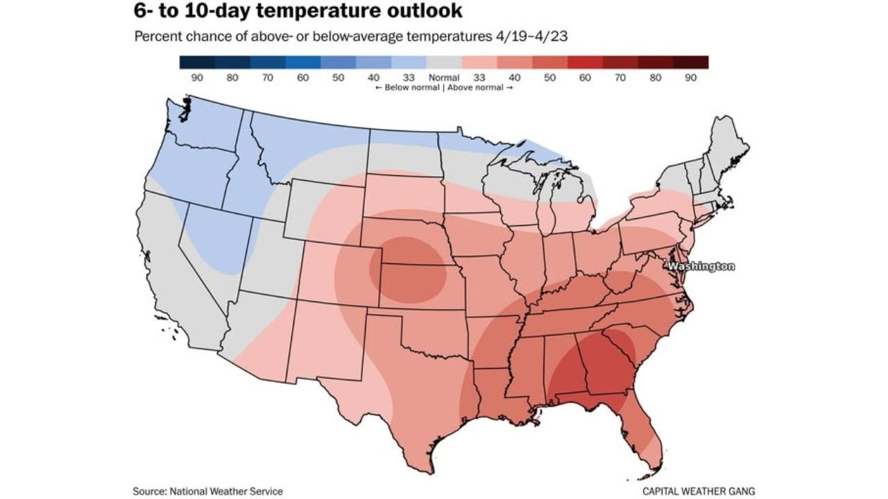
The 6 to 10 Day Outlook — What Comes After the Cool Snap
The 6-10 day temperature outlook covering April 19 through 23 tells an important and nuanced story about what follows this week’s heat and next week’s brief cooldown:
The temperature outlook map shows above-average probability remaining across much of the eastern United States through the April 19-23 window — driven by the lingering warmth still present early Sunday before the cold front arrives and the midweek warmup expected by Wednesday and Thursday of next week. Despite Monday and Tuesday’s below-average readings, the overall period still leans warm because the pattern does not stay cool for long.
Early signals point to a midweek warmup next week — although forecasters note this warmup will probably not be as extreme as the record-threatening heat of this week. The D.C. region appears to be entering a pattern of alternating warm and cool periods through late April, rather than sustaining either extreme for prolonged stretches.
The Pacific Northwest and northern Rockies — shown in blue on the temperature outlook — are the only regions expected to run meaningfully below average during the April 19-23 period, while the Southeast and Gulf Coast shown in deep red continue running well above average through the period.
What D.C., Maryland and Virginia Residents Need to Know Day by Day
Wednesday and Thursday this week:
- Potential 90-degree highs and record-warm overnight lows — heat safety precautions remain essential
- Limit outdoor activity during peak afternoon hours of noon to 6 PM
- Check on elderly neighbors and anyone without reliable air conditioning — the heat has now lasted long enough to be physically taxing even for healthy individuals
Saturday:
- Still well into the 80s — continued above-average warmth before the pattern breaks
- Enjoy the warmth but be aware the cooldown is approaching
Sunday — Transition Day:
- Watch the morning forecast before making outdoor plans — the difference between a 70-degree day and a 55-degree day depends entirely on cold front timing
- Showers possible with cold front passage — carry rain gear for any outdoor activities
- Have a layer ready — temperatures could drop noticeably during the day
Monday and Tuesday:
- Highs in the 60s — possibly 50s in cooler spots
- Morning lows in the 40s — possibly 30s in colder areas of Maryland and Virginia
- This is the coolest stretch of the entire spring so far for the D.C. region — dress accordingly and protect any garden plants that are sensitive to temperatures near freezing in colder spots
Midweek next week:
- Early signals for a warmup returning — though not as dramatic as this week’s historic heat event
From record-threatening 90-degree heat this week to 40-degree mornings early next week, the Washington D.C. region is about to experience one of the most dramatic and rapid temperature reversals of the spring season — and being prepared for both extremes within the same week is exactly what residents across D.C., Maryland, and Virginia need to do right now.
WaldronNews.com will continue tracking the historic D.C. heat event, Sunday’s cold front timing, and the early next week cooldown across the Washington D.C., Maryland, and Virginia region and will provide updates as the transition approaches.