
2026 Atlantic Hurricane Season Expected to Be Less Active as Below Normal Ocean Temperatures From the Gulf to the Coast of Africa Make Tropical Storm Formation Difficult
MIAMI, Florida — The latest sea surface temperature data as of Sunday, May 10, 2026 is pointing toward a less eventful Atlantic hurricane season this year, with below normal ocean temperatures stretching from the Gulf all the way to the Coast of Africa making tropical cyclone formation significantly more difficult than in recent years.
Warmer than normal sea surface temperatures in the North Atlantic will still provide a more favorable zone for any storms that do manage to form, though those cyclones are expected to curve northward rather than threatening the Gulf Coast.
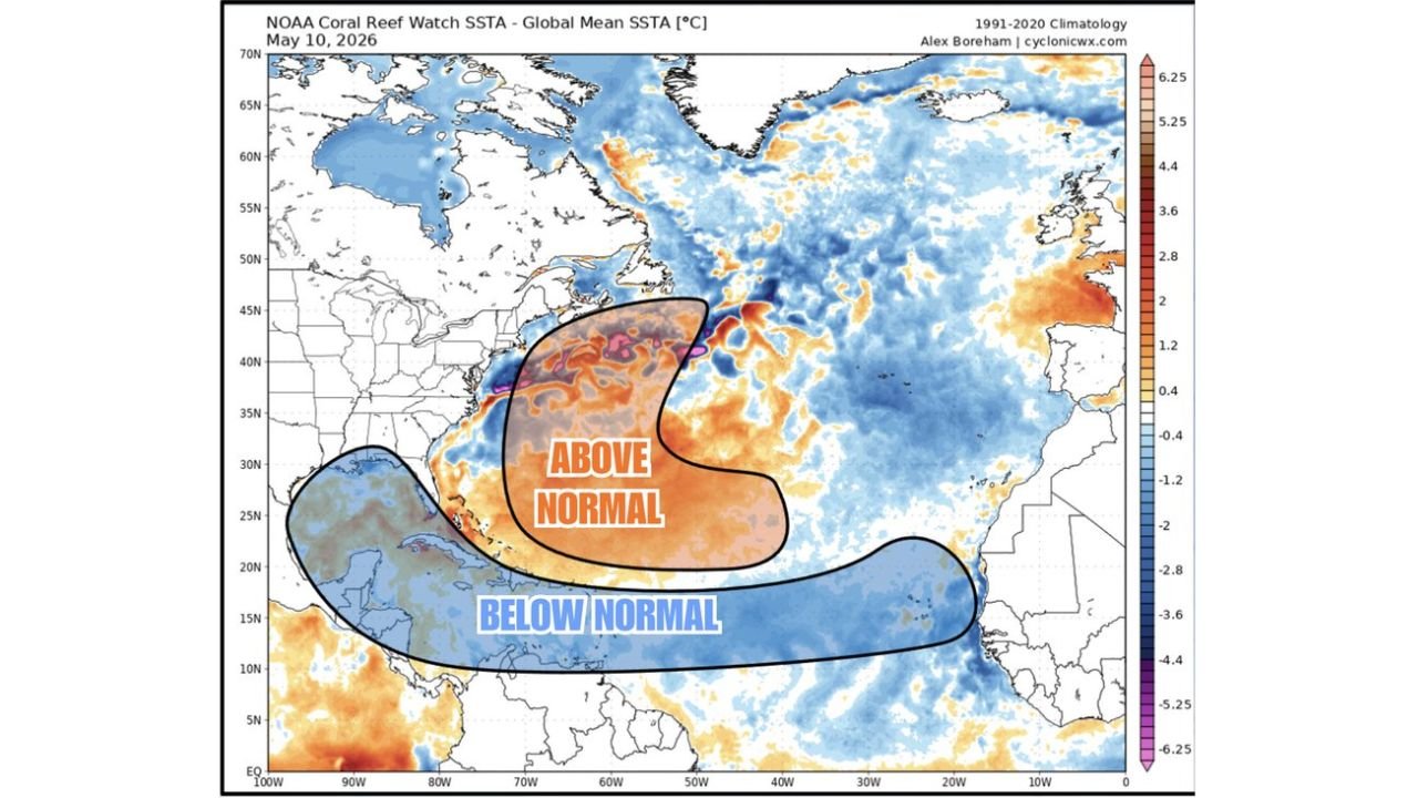
What the Ocean Temperature Map Shows
The sea surface temperature anomaly map valid May 10, 2026 reveals two distinctly different ocean temperature zones that will shape the 2026 hurricane season:
- A large below normal sea surface temperature zone stretches across the tropics from the Gulf of Mexico eastward all the way to the Coast of Africa, shown in blue on the map. This cooler-than-average water makes it significantly harder for tropical storms and hurricanes to form, as warm ocean water is the primary fuel source for tropical cyclone development.
- An above normal sea surface temperature zone is clearly visible in the North Atlantic, shown in orange and red on the map, sitting north of the main tropical development zone. While this warmer water is favorable for tropical activity, its location means any storms that do form are more likely to curve northward than to track toward the Gulf Coast or East Coast.
Why Below Normal Ocean Temperatures Suppress Hurricane Activity
Tropical cyclones need warm ocean water to form and intensify. When sea surface temperatures are below normal across the main development zone from the Gulf to the Coast of Africa, storms struggle to find the energy they need to organize and strengthen:
- Below normal ocean temperatures reduce the amount of heat and moisture available to fuel storm development, meaning fewer tropical disturbances will be able to organize into named storms during the 2026 season.
- Even if a tropical system does manage to form in the below normal temperature zone, it will have a harder time intensifying into a major hurricane without access to the warm water it needs to grow.
- This pattern is a significant shift from recent hurricane seasons that featured well above normal ocean temperatures across much of the tropical Atlantic and Gulf of Mexico.
What the Warmer North Atlantic Means
The above normal sea surface temperatures visible in the North Atlantic on the May 10, 2026 map do introduce some tropical activity potential, but with an important distinction for coastal residents:
- Any tropical cyclones that do manage to form during the 2026 season are expected to recurve northward due to the location of the warmer water in the North Atlantic, which steers storm tracks away from direct Gulf Coast and Caribbean impacts.
- This recurving track pattern is generally less threatening for Gulf Coast states like Texas, Louisiana, Mississippi, Alabama and Florida’s Gulf side compared to seasons where storms track straight westward into warmer tropical waters.
- However, recurving storms can still pose a significant threat to the East Coast and New England states, and residents in those areas should not interpret a less active season as a reason to be unprepared.
What This Means for Hurricane Season Preparation
Even in a forecast less active hurricane season, preparation remains essential for all coastal residents:
- A less active season does not mean a no-impact season. It only takes one storm making landfall near your community to cause catastrophic damage, regardless of overall seasonal activity levels.
- Residents across the Gulf Coast, East Coast and Caribbean should still have a hurricane evacuation plan, emergency supply kit and family communication plan ready before the peak of hurricane season in August and September.
- Continue monitoring seasonal forecasts as ocean temperature patterns can shift between now and the peak of hurricane season, potentially changing the overall activity outlook for 2026.
WaldronNews.com will continue tracking 2026 Atlantic hurricane season sea surface temperature trends and tropical development potential and will provide updates as ocean conditions and storm formation chances develop through hurricane season.