
2:25 PM Severe Weather Update for Illinois, Iowa and Wisconsin as Strong Long Track Tornadoes Possible 4 PM to 9 PM With Three Separate Storm Zones Now Defined Across the Region
CHICAGO, Illinois — A critical 2:25 PM severe weather update has sharpened the picture dramatically for Illinois, Iowa, and Wisconsin this Tuesday afternoon and evening — with three distinct storm development zones now clearly defined across the region, a primary long-track tornado window of 4:00 PM to 9:00 PM identified for the most dangerous corridor, and a storm sequence that will continue pushing east into northwest Indiana and southwest Michigan after 8:00 to 9:00 PM tonight.
The situation is evolving rapidly and the timing is now clear enough that every resident across the three threat zones needs to know exactly what is coming, when it is coming, and what the specific danger is in their area.
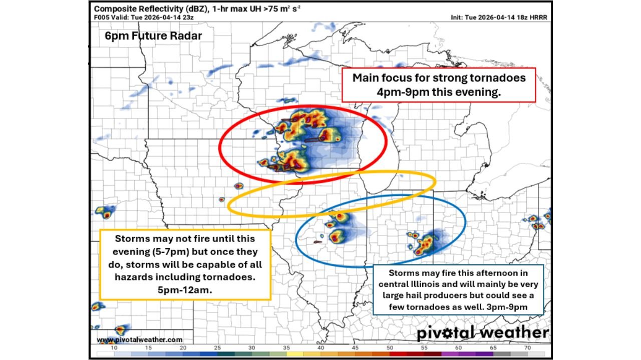
Three Separate Storm Zones — Know Which One You Are In
ZONE 1 — RED OVAL — Eastern Iowa Into Southwest Wisconsin and Northwest Illinois: Main tornado focus: 4:00 PM to 9:00 PM
This is the most dangerous zone on today’s map — the primary focus for strong, long-track tornadoes this evening. Storms developing across eastern Iowa near the warm front will move east into southwest Wisconsin and northwest Illinois during the 4:00 PM to 9:00 PM window — and these storms will be operating in the best environment for strong, long-track tornadoes of the entire day.
The warm front boundary across eastern Iowa and the Iowa-Wisconsin-Illinois tri-state corridor is the specific atmospheric feature that makes this zone the tornado bullseye. Supercells that develop along or just south of this warm front will immediately tap into the concentrated low-level wind shear available along the boundary — the precise ingredient that enables long-track tornado production. These are not brief spin-up tornadoes. These are potentially long-lived, violent rotating storms that can remain on the ground across multiple counties.
Communities in Zone 1 that face the greatest immediate tornado risk:
- Iowa: Dubuque, Dyersville, Manchester, and eastern Iowa communities along the warm front corridor
- Wisconsin: Prairie du Chien, Richland Center, Madison, and southwest Wisconsin communities in the storm’s northeast track
- Illinois: Galena, Freeport, Rockford, and northwest Illinois communities directly in the storm path
ZONE 2 — YELLOW OVAL — Northern Illinois: Storm window: 5:00 PM to 12:00 AM — All hazards including tornadoes
Storms across northern Illinois are currently being held back by a weakening cap — and the latest update confirms they may not fire until this evening between 5:00 and 7:00 PM. However, once that cap breaks, the update is explicit: storms will be capable of all hazards including tornadoes from 5:00 PM through midnight.
The northern Illinois zone — covering Chicago, Rockford, Aurora, Joliet, Ottawa, and the broader northern Illinois corridor — represents a sustained and extended severe weather threat through the overnight hours. Unlike Zone 1 where the tornado threat is most concentrated in the 4-9 PM window, Zone 2 maintains all-hazards severe weather potential through midnight — meaning Chicago metro residents face a lengthy and dangerous storm window that extends well into the overnight hours.
ZONE 3 — BLUE OVAL — Central Illinois: Storm window: 3:00 PM to 9:00 PM — Very large hail primary, tornadoes possible
Storms may fire this afternoon across central Illinois — making Zone 3 the earliest-developing and most imminent storm zone on today’s map. These storms will mainly be very large hail producers as they move east across central Illinois communities — but a tornado or two is also possible as they go severe warned very quickly moving eastward. The storm speed means warning lead times will be short.
Communities in Zone 3 — Springfield, Peoria, Bloomington, Decatur, Galesburg, Champaign, and the broader central Illinois corridor — face an active storm threat beginning as early as 3:00 PM this afternoon and continuing through 9:00 PM.
The Transition After 8:00 to 9:00 PM — Indiana and Michigan
After 8:00 to 9:00 PM tonight, the storm system undergoes a significant character change as it pushes east. The tornado threat across Illinois will transition to a large hail and damaging wind risk as storms organize into a broader line and march eastward into:
- Northwest Indiana: Gary, Hammond, Michigan City, Valparaiso, and the northwest Indiana corridor will face the wind and hail threat as the storm line pushes through after 9:00 PM
- Southwest Michigan: Benton Harbor, St. Joseph, Kalamazoo, and southwest Michigan communities are in the path of the advancing storm line during the late evening hours
This transition does not mean the threat is over — it means the hazard type changes from tornado-dominant to damaging wind and large hail dominant as the system evolves. Northwest Indiana and southwest Michigan residents should be prepared for significant storm impacts during the 9:00 PM to midnight window.
Exact Timing Breakdown — What Hits When
| Time Window | Zone | Primary Threat |
|---|---|---|
| 3:00 PM – 9:00 PM | Central Illinois | Very large hail, tornadoes possible |
| 4:00 PM – 9:00 PM | Eastern Iowa / SW Wisconsin / NW Illinois | Strong long-track tornadoes — HIGHEST RISK |
| 5:00 PM – 7:00 PM | Northern Illinois | Cap breaks — storms begin firing |
| 5:00 PM – 12:00 AM | Northern Illinois / Chicago | All hazards including tornadoes |
| 8:00 PM – 9:00 PM | All zones transition | Tornado threat shifts to wind and hail |
| 9:00 PM – 12:00 AM | Northwest Indiana / SW Michigan | Damaging winds, large hail |
What Each Zone Must Do Right Now
Zone 1 — Eastern Iowa, Southwest Wisconsin, Northwest Illinois — 4 PM is your deadline:
- The tornado window opens in less than two hours — be sheltered and weather-aware before 4:00 PM
- Long-track tornadoes from this zone can remain on the ground for 30 minutes or more — a single warning may cover multiple counties in your path
- Dubuque, Madison, Galena, and Freeport residents — you are in the primary tornado zone. Move to your lowest interior room the moment a tornado warning is issued for your county — do not wait
Zone 2 — Northern Illinois / Chicago — 5 to 7 PM cap break expected:
- The 5:00 to 7:00 PM window is when storms are expected to fire across northern Illinois — treat this as your active preparation deadline
- Chicago metro residents — your storm threat extends through midnight. Weather alerts must be set to override Do Not Disturb for the entire evening and overnight period
- Once storms fire in northern Illinois they will be capable of all hazards immediately — do not assume the first storms are just rain showers
Zone 3 — Central Illinois — Storms possible starting 3:00 PM:
- Springfield, Peoria, Bloomington, and Decatur — storms could develop in your area within the next hour. Be weather-aware immediately
- Very large hail is the primary threat but a tornado is possible — shelter at the first tornado warning, do not wait to assess whether hail damage is occurring
Zone transition — Northwest Indiana and Southwest Michigan:
- Gary, Hammond, Kalamazoo, and Benton Harbor — prepare for a damaging wind and large hail event arriving after 9:00 PM tonight
- Set overnight weather alerts now — the storm line arrives in your area during evening hours when many residents may be winding down
The three-zone severe weather outbreak across Illinois, Iowa, Wisconsin, Indiana, and Michigan is unfolding right now. The most dangerous window — long-track tornadoes from 4:00 PM to 9:00 PM across eastern Iowa and northwest Illinois — is less than two hours away.
WaldronNews.com will continue providing live updates across all three storm zones through tonight and will immediately report tornado warnings, confirmed tornadoes, and storm damage as the outbreak unfolds across Illinois, Iowa, Wisconsin, Indiana, and Michigan.