
California Coastal Waters Hit Warmest April Temperatures Ever Recorded as Category 5 Marine Heatwave and Super El Nino Signal Raise Hurricane Landfall Risk for Southern California This Year
LOS ANGELES, California — California’s coastal waters have reached a historic and alarming milestone — the warmest ocean temperatures ever recorded for the month of April — as a severe to extreme marine heatwave rages off the coasts of California and Baja California, locally reaching Category 5 intensity on the marine heatwave scale and sending signals that 2026 could be one of the most consequential and unusual weather years in California’s recorded history.
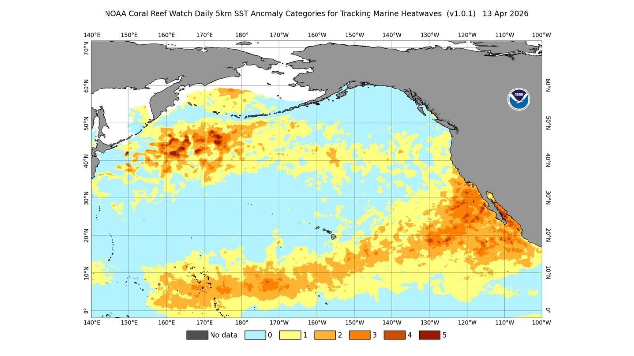
The marine heatwave is not an isolated event. An extraordinary and continuous band of strong to severe marine heatwave conditions extends from the Marshall Islands all the way to the California coastline — an enormous stretch of the Pacific Ocean running tens of thousands of miles that is running at historically anomalous warm temperatures. The dark red and deep orange shading dominating the Sea Surface Temperature anomaly map dated April 13, 2026 tells the story visually — the Pacific is not just warm, it is historically and exceptionally warm in ways that carry serious long-range consequences for California, the broader West Coast, and potentially the entire western United States.
What Category 5 Marine Heatwave Means for California
A Category 5 marine heatwave — the highest classification on the marine heatwave intensity scale — means ocean temperatures off California and Baja California are running at their most extreme anomaly levels. Just as a Category 5 hurricane represents the most intense wind and storm surge conditions possible, a Category 5 marine heatwave represents ocean temperatures so far above the historical norm that the impacts on marine ecosystems, coastal weather patterns, and atmospheric circulation are profound and far-reaching.
For California’s coastal communities — from San Diego and Los Angeles through Santa Barbara, Monterey, and San Francisco — record warm coastal ocean temperatures in April carry immediate and compounding consequences:
Marine ecosystem collapse risk is elevated significantly when ocean temperatures reach Category 5 anomaly levels. The kelp forests, fisheries, and marine mammal populations that define California’s coastal ecology are deeply sensitive to sustained temperature anomalies of this magnitude. Coral bleaching events, fish die-offs, and harmful algal blooms all become significantly more likely when coastal waters are this far above historical norms.
Atmospheric moisture and humidity along the California coast will be directly influenced by the record warm ocean temperatures through the summer months. A warmer ocean surface means more evaporation and more moisture entering the atmosphere along the coast — setting the stage for the very humid summer in Southern California that is now being explicitly forecast.
The Super El Niño Signal — And What It Means for Southern California Hurricanes
The most startling and historically significant implication of California’s record April ocean temperatures is the rapidly strengthening El Niño expected to emerge in the coming weeks and intensify toward what could be a Super El Niño by autumn 2026.
A Super El Niño — characterized by exceptionally warm sea surface temperatures in the central and eastern tropical Pacific — is the rarest and most impactful form of El Niño, occurring only a handful of times in the modern instrumental record. The last notable Super El Niño events of 1997-98 and 2015-16 produced dramatic and far-reaching weather pattern disruptions across the globe.
But the implication that demands immediate attention from Southern California residents is direct and unprecedented in its clarity: if there was ever a year for a tropical storm or hurricane to make landfall in Southern California, 2026 is it.
This is not a casual observation. A Super El Niño combined with record warm coastal waters creates the specific set of conditions that historically makes tropical storm intrusion into Southern California and Baja California most likely. The warm ocean water that extends continuously from the tropics to the California coastline provides the fuel source that tropical systems need to survive the typically cold upwelling waters that normally prevent any tropical development from reaching Southern California. In a year when those waters are record warm from the Marshall Islands to the coast, that barrier is dramatically reduced.
The last time a tropical storm made landfall in Southern California was 1939 — an event considered so anomalous it was barely believed when it occurred. The atmospheric and oceanic setup building for 2026 is being watched precisely because it resembles the conditions that made that and other rare California tropical events possible.
The Pacific Marine Heatwave — Scale and Scope
The Sea Surface Temperature anomaly map for April 13, 2026 shows the full geographic scale of what is happening across the Pacific:
- California and Baja California coastline: Deep orange and red Category 4-5 anomalies running the entire length of the California coast from the Oregon border south through Baja California
- North Pacific: A massive zone of Category 3-5 marine heatwave conditions covering an enormous swath of the northern Pacific from approximately 40°N to 55°N — including the waters off the Pacific Northwest and Alaska
- Central Pacific around Hawaii: Category 2-3 anomalies surrounding the Hawaiian Islands
- Tropical Pacific: A continuous band of warm anomalies extending from the Marshall Islands westward — the signature of the developing El Niño in the tropical Pacific that will strengthen through the coming months
- Eastern Pacific off Mexico and Central America: Category 3-4 anomalies running down the Mexican Pacific coastline — the waters that tropical storms traverse when targeting the Baja California and Southern California region
The sheer geographic scale of this Pacific warming is extraordinary. There is virtually no pathway from the tropics to the California coastline that runs through cold, storm-suppressing waters in 2026 — which is precisely what makes this year’s setup so historically unusual for tropical weather risk in Southern California.
What Southern California Residents and Communities Need to Understand for 2026
Hurricane risk in Southern California is typically so low that most residents have never considered it a realistic threat. The combination of cold upwelling coastal waters, unfavorable atmospheric patterns, and historical precedent has made Southern California one of the safest regions in the United States from tropical weather. That calculus is changing in 2026, and residents deserve to understand why:
The record warm April coastal waters, the Category 5 marine heatwave locally, and the rapidly developing Super El Niño together create the most favorable set of conditions for tropical storm survival along the California coastline seen in the modern era. This does not mean a hurricane will make landfall in Southern California in 2026 — the probability remains low in absolute terms — but the conditions that make it possible are more aligned this year than they have been in decades, and awareness is the first line of preparation.
What to Watch in the Coming Months
- Monitor El Niño development closely through May and June — the rate at which it intensifies toward Super El Niño status will be a critical indicator of 2026’s overall weather risk for California
- Southern California residents should be aware that tropical weather preparedness — something rarely discussed in the region — is worth familiarizing yourself with before the peak tropical season of August through October
- Marine ecosystem impacts will begin manifesting along the California coast through spring and summer as Category 5 heatwave conditions persist — fishermen, divers, and coastal businesses should monitor conditions closely
- The very humid summer forecast for Southern California represents a significant departure from the typically dry and comfortable coastal summer climate — residents should be prepared for unusual mugginess and elevated overnight temperatures through the summer months
- Watch for tropical development in the Eastern Pacific during the late summer and early fall — any system that forms in warm Mexican Pacific waters and tracks northward toward Baja California in 2026 carries higher-than-normal potential to maintain intensity as it approaches Southern California
California’s ocean has never been this warm in April. The Pacific is sending signals that 2026 will be a year unlike any in recent memory for the West Coast — and Southern California residents have reason to pay close attention to what develops over the coming months.
WaldronNews.com will continue tracking the Pacific marine heatwave, El Niño development, and the implications for Southern California weather through the 2026 season and will provide updates as conditions evolve.