
Meteorologists Reject GFS Model Showing 40-Inch Christmas Eve Snowstorm Across New York and the Northeast, Calling the Forecast “Impossible” Under Current Atmospheric Patterns
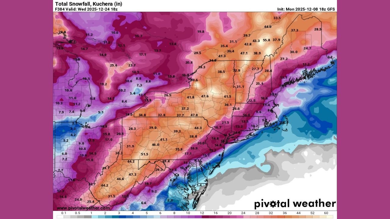
UNITED STATES — Weather forecasters say the latest GFS model run projecting a massive 40-inch snowstorm on Christmas Eve across New York, Pennsylvania, and New England is not scientifically realistic, noting that the upper-atmosphere pattern simply does not support such an extreme event.
Meteorologists reviewing Monday’s 18z data called the model output “fun to look at” but emphasized that the odds of this forecast verifying are 0%, pointing to significant inconsistencies between snowfall projections and the 500mb height pattern, which governs large-scale storm development.
GFS Snowfall Map Shows Extreme Totals That Do Not Match Reality
The snowfall map circulating online shows 30 to 50 inches of accumulation across wide swaths of:
- New York
- Pennsylvania
- Vermont, New Hampshire, and Maine
- Northern New Jersey and Connecticut
Some localized areas display historic-level totals exceeding 55 inches, an amount meteorologists classify as “model fantasy.”
One meteorologist summarized it bluntly:
“This is just not gonna happen. A 40-inch Christmas Eve storm would be something, but there is a 0% chance.”
Experts caution that long-range GFS snowfall maps often display unrealistic output due to model noise and limitations far beyond reliable forecasting range.
The 500mb Pattern Completely Contradicts the Snowfall Map
Side-by-side with the snowfall projection is the 500mb height and anomaly chart, valid for December 24, which paints a very different picture.
The 500mb analysis shows:
- No strong coastal trough
- No deep negative height anomaly over the Northeast
- No significant storm system capable of producing extreme snowfall
Instead, the pattern reveals a broad trough across central and eastern Canada, with energy displaced in ways that cannot generate a blockbuster East Coast snowstorm.
Meteorologists emphasize that major snow events require:
- A phasing of northern and southern energy
- A coastal low developing off the Mid-Atlantic
- A negative NAO blocking pattern
- Strong moisture transport
- Cold air locked into place at all levels
None of these ingredients appear in the current setup.
Why Long-Range Snow Maps Often Show “Fantasy Storms”
The GFS is known for occasionally producing hyper-inflated snowfall maps at long-range intervals (300+ hours). These can stem from:
- Over-amplified storm tracks
- Incorrect atmospheric phasing
- Enhanced moisture assumptions
- Grid-scale feedback errors
- Atmospheric patterns that do not physically align with the shown output
Such runs are typically discarded by meteorologists, especially when not supported by:
- Ensemble guidance
- 500mb patterns
- Other major models such as the ECMWF or Canadian
Experts recommend using long-range snowfall maps for pattern-watching, not literal accumulation forecasts.
What Residents in the Northeast Should Actually Expect
Although a 40-inch storm is off the table, meteorologists say the region may still experience:
- Periodic cold shots
- Lake-effect snow in New York and Michigan
- Clipper systems bringing light to moderate snow
- Potential coastal disturbances closer to Christmas
But nothing in current modeling supports a historic, widespread blizzard.
Forecast confidence will improve as the holiday approaches, but for now, forecasters emphasize staying grounded in realistic atmospheric signals, not exaggerated long-range output.
Will the holiday week bring real snow or just more model noise? Stay tuned for the latest verified forecasts and winter weather updates only at WaldronNews.com.