
Illinois, Indiana and Kentucky Face Level 3 Enhanced Risk Severe Outbreak With Strong Long-Tracked Tornadoes Possible Monday as 60% Severe Weather Probability Covers the Midwest and Mid-South
CHICAGO, Illinois — A significant severe weather outbreak is taking shape across the Midwest and Mid-South for Monday, April 27, with forecasters maintaining a Level 3 Enhanced Risk across parts of Illinois, Indiana and Kentucky while acknowledging that a Level 4 Moderate Risk was actively considered before uncertainties around early day convection held the outlook back. A significant outbreak of severe storms and tornadoes — including some that may be strong and long-tracked — remains possible across this corridor through Monday night.
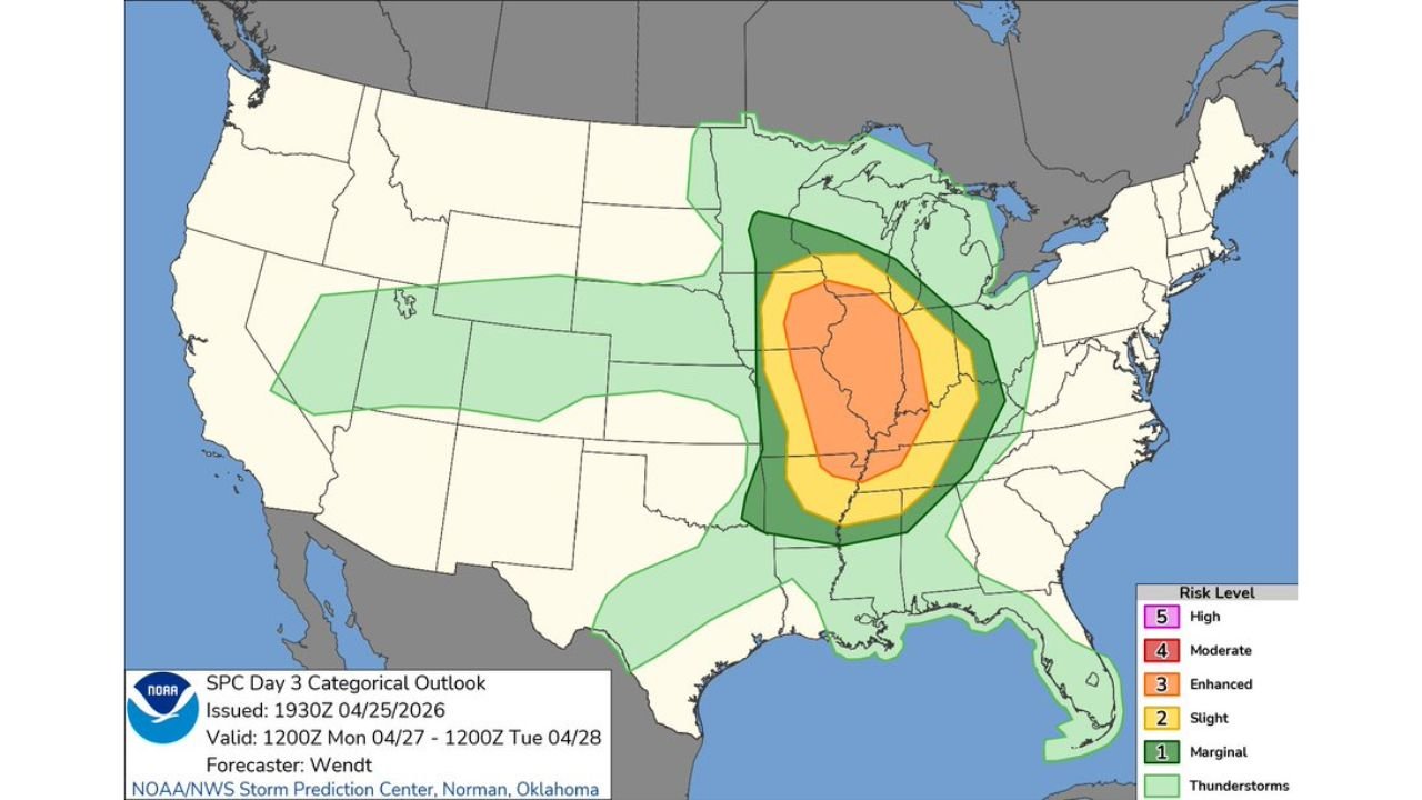
The Risk Level and Why It Stopped at Enhanced
The SPC Day 3 Categorical Outlook valid 1200Z Monday April 27 through 1200Z Tuesday April 28 places a Level 3 Enhanced Risk at the core of Monday’s severe weather threat, centered over Illinois, Indiana and western Kentucky. Surrounding that is a Level 2 Slight Risk extending through much of the Midwest and Deep South, and a Level 1 Marginal Risk reaching from Nebraska and Kansas eastward through Ohio and into the Southeast.
The reason forecasters stopped short of a Level 4 Moderate Risk is not the atmospheric setup — it is timing uncertainty. Early day convection, particularly MCS activity pushing through the region overnight into Monday morning, could stabilize the atmosphere and limit the afternoon severe weather window. If that early convection underperforms and clears in time, the setup has the ingredients to support a Moderate Risk outbreak. The data leaves that door open.
The Probability Numbers — What 60% Actually Means
The SPC Day 3 Probabilistic Outlook tells the most direct story of Monday’s threat. The core of the risk zone shows:
- 60% total severe weather probability — the highest category on the probabilistic scale — centered over central Illinois and northern Indiana, with the hatched overlay indicating Intensity 2 storms capable of producing significant tornadoes, very large hail and damaging straight-line winds
- 45% probability extending through a broader zone covering southern Illinois, Indiana and western Kentucky
- 30% probability across the outer Enhanced Risk zone including portions of Missouri, Tennessee and Ohio
- 15% probability reaching through the broader Slight Risk area across the Midwest and Mid-South
- 5% probability covering the outer Marginal zone from Nebraska to Georgia
The hatched pattern overlaid on the 60% and 45% zones is a specific signal that significant severe weather — defined as tornadoes rated EF2 or stronger, hail 2 inches or larger, or wind gusts exceeding 75 mph — is expected within that footprint.
What Strong and Long-Tracked Tornadoes Means for This Region
Forecasters explicitly flagged the possibility of strong and long-tracked tornadoes within this outbreak. A long-tracked tornado is one that stays on the ground for an extended distance — sometimes covering 20, 40 or even 100 or more miles without lifting. These are the storms that cause the most widespread destruction because they cross multiple counties and affect large numbers of communities in a single continuous path.
The atmospheric ingredients supporting this threat include:
- Deep wind shear — the change in wind speed and direction with height that allows thunderstorms to rotate
- Strong CAPE (Convective Available Potential Energy) — the fuel load available for explosive thunderstorm development in the warm sector
- A well-defined dryline and cold front intersection acting as the focal point for supercell initiation
- Veering winds with height supportive of sustained mesocyclone development within discrete supercells
Cities and States in the Risk Zone
Level 3 Enhanced Risk — highest current designation:
- Chicago, Illinois
- Springfield, Illinois
- Peoria, Illinois
- Indianapolis, Indiana
- Evansville, Indiana
- Louisville, Kentucky
- Paducah, Kentucky
Level 2 Slight Risk — elevated threat zone:
- St. Louis, Missouri
- Nashville, Tennessee
- Memphis, Tennessee
- Columbus, Ohio
- Detroit, Michigan
- Milwaukee, Wisconsin
Level 1 Marginal Risk — outer boundary:
- Kansas City, Missouri
- Cincinnati, Ohio
- Birmingham, Alabama
- Atlanta, Georgia
The Early Convection Variable — The One Thing That Changes Everything
The single factor that determines whether Monday becomes a historic outbreak or a significantly limited event is early day convection. If an overnight MCS pushes through the Enhanced Risk zone and leaves behind a stable, cloud-covered atmosphere by morning, afternoon storm initiation becomes difficult or impossible. Surface temperatures cannot rise fast enough to destabilize the capped atmosphere, and the severe weather window closes before it opens.
Watch these signals Monday morning:
- MCS position by 8 a.m. local time — if widespread rain and thunder are still ongoing across Illinois and Indiana, the washout scenario is gaining ground
- Sky conditions by 10 a.m. — clearing skies and rapid surface heating by mid-morning dramatically increase the probability of the afternoon outbreak scenario
- Surface dewpoints — values holding at 65°F or above across the warm sector indicate the moisture axis is intact and available for explosive storm development
- Afternoon storm mode — discrete supercells are the primary tornado producers; a linear squall line is more likely to produce damaging winds than significant tornadoes
What to Watch as Monday Develops
- Residents across Illinois, Indiana and Kentucky should have multiple ways to receive tornado warnings Monday afternoon and evening — a phone, a weather radio and a trusted weather app running simultaneously
- This is a go-inside-now threat when warnings are issued, not a watch-from-the-porch situation — long-tracked tornadoes can intensify rapidly and cover ground faster than most people expect
- Manufactured homes and mobile homes across the Enhanced Risk zone should have a pre-identified shelter location before Monday morning
- The severe weather window, if it opens, is most likely Monday afternoon into Monday evening — plan outdoor activities and travel accordingly
- Communities across the 60% probability hatched zone in central Illinois and northern Indiana face the highest individual risk and should treat any tornado watch issued Monday as a serious, act-now signal
WaldronNews.com will continue tracking this outbreak through Monday and provide updates on risk upgrades, tornado warnings and storm reports as the severe weather event unfolds.