
Iowa, Nebraska and South Dakota Face Heavy Rain Washout Risk as Morning MCS Threatens to Erase Afternoon Severe Weather Window Across the Northern Plains
DES MOINES, Iowa — The setup for Monday, April 27 across Iowa, Nebraska and South Dakota carries real severe weather potential — and a real threat of never delivering it. A mesoscale convective system tracking through the northern tier of the risk zone overnight could dump heavy rainfall across the region and stabilize the atmosphere before afternoon heating has any chance to work, turning a high-ceiling severe weather day into a rain-soaked washout before it begins.
How Historic the Precipitation Signal Actually Is
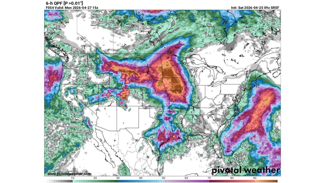
The 6-hour QPF forecast valid Monday at 15z, initialized from the Saturday morning SREF ensemble, shows one of the more aggressive precipitation footprints of the spring so far across the northern Plains. The heaviest totals, shaded in dark orange and brown on the ensemble output, are centered over central Iowa and eastern Nebraska, with values pushing into the 70 to 90 millimeter range in the highest-end solutions. That is a significant rainfall signal for a region that will already be dealing with morning convective debris from the overnight MCS, meaning some of the heaviest totals could fall on ground already saturated by earlier storms.
The spatial extent of this system is not limited to the core:
- A secondary precipitation band pushes through the southern Plains
- Additional activity is ongoing along the Pacific coast
- The upper Midwest shows scattered contributions from the broader pattern
This is a continental-scale moisture event, not a localized squall line.
The Washout Risk — And the Window That May Close
The critical variable for Monday is not the energy in the atmosphere but the timing of the MCS. If overnight convection fires aggressively and pushes through northern Nebraska, southern South Dakota and northwestern Iowa before dawn, the residual cloud cover and outflow boundaries left behind could cap the atmosphere through the critical midday window. CAPE — Convective Available Potential Energy, the measure of how much fuel the atmosphere has available for thunderstorm development — needs time and surface heating to recover after an MCS passage. If that recovery does not happen before early afternoon, the severe weather window closes without opening.
Forecasters describe this explicitly as a washout risk from the north side, meaning areas along and above a line from Sioux Falls to Omaha to Des Moines face the highest probability of seeing the afternoon potential erased by morning activity.
Cities and States in the Risk Zone
The primary zone stretches across Iowa, Nebraska, South Dakota, Kansas and Minnesota, with secondary impacts reaching into Missouri and North Dakota. Key cities sitting within or adjacent to the heaviest projected precipitation corridors include:
- Des Moines, Iowa
- Omaha, Nebraska
- Lincoln, Nebraska
- Ames, Iowa
- Sioux Falls, South Dakota
- Kansas City, Missouri
- Minneapolis, Minnesota
Residents across all of these areas should plan for periods of heavy rain regardless of whether the severe weather component materializes, as the moisture and lift supporting this system are substantial and not conditional on afternoon thunderstorm development.
Why the Setup Gets Complicated
The favorable elements are genuine:
- The convective ceiling — the depth of atmosphere available to support storm growth — is high
- Wind shear profiles are supportive of organized convection
- Surface moisture is deep across the entire corridor
On paper, the ingredients for a significant severe weather outbreak exist. The complication is that model guidance diverges significantly on how far south and east the overnight MCS pushes before weakening, which creates a wide range of possible outcomes by afternoon. The difference between a major severe weather day and a washed-out rain event comes down entirely to how aggressively convection fires overnight and how quickly it clears.
What to Watch as Monday Unfolds
Watch morning radar trends across South Dakota and northern Nebraska closely before 9 a.m. local time. Key signals to monitor:
- Widespread, slow-moving convection still present through mid-morning signals the washout scenario is winning
- Rapid clearing and storm weakening before noon reopens the afternoon severe weather window
- Outflow boundary position left behind by the MCS will be critical — any lingering boundary could serve as a focus for afternoon redevelopment even if the original MCS underperforms
- CAPE recovery rate through mid-morning will determine whether surface-based storm development is possible by early afternoon
Residents across Iowa, Nebraska and South Dakota should have weather alerts active through the entire day Monday, as the timing of any severe weather threat — if it materializes at all — could shift rapidly depending on how morning convection evolves.
WaldronNews.com will continue tracking this system through Monday and provide updates on MCS progression, afternoon severe weather potential and precipitation totals as conditions develop.