
Oklahoma Tornado Window Closing Fast as Over-Convection Kills Supercell Structure and Storms Merge Into Wind and Hail Threat
OKLAHOMA CITY, Oklahoma — The fail mode that forecasters warned about earlier today is now happening across Oklahoma. Over-convection has taken hold, meaning too many storms have fired simultaneously and are now competing with each other for the same warm inflow air. That competition is strangling the individual supercell structure that produces long-track tornadoes, and these cells are on a path to merge into a large Mesoscale Convective System within the next hour or so.
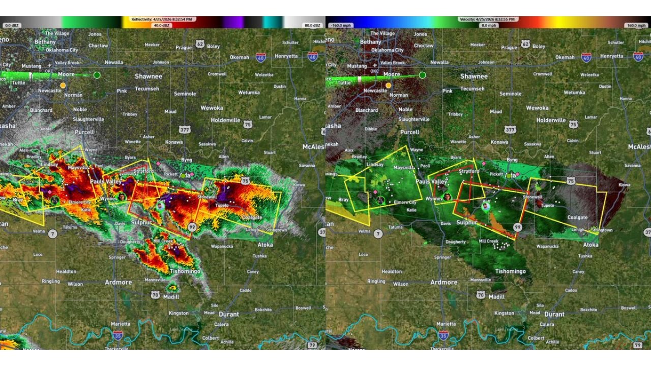
The radar at 6:32 PM shows the current state of play across south-central Oklahoma with warning boxes active between Pauls Valley, Wynnewood, Sulphur, Elmore City, and toward Atoka. Both a Severe Thunderstorm Warning and a Tornado Warning are still active in this corridor, but the velocity data on the right panel shows the rotational signature is weakening compared to what a more isolated supercell would show.
What Over-Convection Means and Why It Matters Tonight
The atmosphere over Oklahoma loaded up with such extreme instability today that storms fired in too many locations simultaneously rather than allowing one or two discrete supercells to dominate the environment. When this happens, individual storms cannot maintain clean, unobstructed access to the warm humid surface air they need to sustain powerful rotation. Each storm is essentially stealing inflow from its neighbors, and the competition weakens all of them.
The result is a collection of storms that individually lack the organized rotation of a true isolated supercell, but collectively represent a large and dangerous convective system. As these cells merge into a Mesoscale Convective System over the next hour, the tornado production capability drops significantly. The MCS that forms will then track east and southeast producing primarily very large hail and damaging straight-line winds rather than tornadoes.
This is the exact scenario forecasters described earlier today as the primary fail mode for Oklahoma’s tornado potential. The atmospheric ingredients were extraordinary, but the cap did not hold long enough to prevent too many storms from firing at once.
The Next Hour Is Still a Tornado Window
Despite the over-convective trend, the storms currently active between Pauls Valley and Atoka retain tornado potential for approximately the next hour before full merger into an MCS. The velocity data shows rotation still present in the warning-producing cells, and the tornado warning currently active for this corridor reflects real atmospheric rotation that could produce a brief tornado before the structure degrades completely.
Anyone in Pauls Valley, Wynnewood, Sulphur, Davis, Elmore City, Coalgate, and communities along the active warning corridor should remain sheltered until these warnings expire. The tornado window is closing but it is not yet closed.
Ardmore, Durant, and Tishomingo in the southern portion of the radar image are downstream from the current activity. As the MCS consolidates and tracks southeast over the next couple of hours, the wind and hail threat for these communities increases even as the tornado threat decreases.
What the MCS Phase Looks Like for Oklahoma Tonight
Once the cells fully merge into a Mesoscale Convective System, the storm system will organize into a large, fast-moving complex capable of producing two primary hazards across a wide area.
Very large hail in the forward portion of the MCS is the first hazard. MCS systems can maintain significant hail-producing cores in their leading convective line, and given the extreme instability still available across Oklahoma and into Arkansas, large hail with the leading line is expected tonight.
Damaging straight-line winds in the stratiform region and from bowing segments in the leading line represent the second hazard. A well-organized MCS with the jet stream overhead can produce wind gusts exceeding 60 to 70 mph across wide swaths of territory. Communities from Ardmore and Durant eastward through Atoka, McAlester, and into eastern Oklahoma and western Arkansas face this wind threat through the evening and overnight hours.
The Focus Shifts East and South
With the Oklahoma tornado window closing, the severe weather focus for tonight shifts to eastern Oklahoma and Arkansas where the MCS will track. Fort Smith, Fayetteville, and communities across northwest Arkansas should be monitoring the situation closely through the evening. The MCS arriving from Oklahoma will bring the wind and hail threat to these areas within the next several hours.
Memphis and west Tennessee remain in the broader overnight threat zone as the system continues tracking east after crossing Arkansas.
WaldronNews.com will continue tracking tonight’s evolving storm system across Oklahoma and Arkansas and provide updates as the MCS develops and tracks east.