
Chicago, Illinois and Milwaukee, Wisconsin Lead Flooding Concerns Monday as 1 to 3 Inches of Heavy Rain Targets the Agricultural Belt From Nebraska Through the Great Lakes
CHICAGO, Illinois — Monday’s severe weather system is not arriving without a significant rainfall and flooding companion. Flooding concerns are running parallel to the severe storm threat across the Midwest, with 24-hour rainfall totals from 2 AM April 27 through 2 AM April 28 showing a concentrated heavy rain corridor cutting through Nebraska, Iowa, Illinois and Wisconsin. Streaks of 1 to 3 inches or more are possible across the flooding concern zone, and the Agricultural Belt stretching from eastern Nebraska through central Illinois faces the greatest combined impact from both the rainfall totals and the eastward extent of the moisture plume.
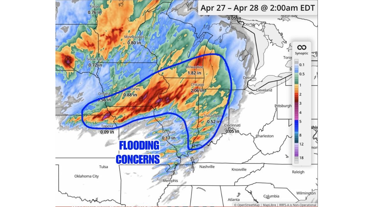
The 24-Hour Rainfall Totals by City
The forecast rainfall map makes the core flooding corridor unmistakably clear. The heaviest totals are concentrated across a northwest-to-southeast axis from Omaha through Chicago and into Milwaukee:
- Chicago, Illinois — 2.06 inches — highest total among major metros, sitting inside the deep red shading on the forecast map
- Milwaukee, Wisconsin — 1.82 inches — second heaviest total, with the urban corridor between Chicago and Milwaukee at elevated flash flood risk
- Des Moines, Iowa — 0.88 inches — meaningful accumulation for a city already seeing active convection from the broader system
- Omaha, Nebraska — 0.56 inches — on the western edge of the flooding concern zone but still inside the impactful rainfall footprint
- Fargo, North Dakota — 0.76 inches — northern tail of the moisture plume reaching into the upper Plains
- Minneapolis, Minnesota — 0.80 inches — metro area seeing moderate accumulation from the system’s northern extent
- Sioux Falls, South Dakota — 0.72 inches — consistent with the broader Plains rainfall signal
- Indianapolis, Indiana — 0.52 inches — lighter end of the corridor but enough to contribute to localized flooding in low-lying areas
- St. Louis, Missouri — 0.17 inches — southern fringe of the main flooding concern zone
- Topeka, Kansas — 0.09 inches — largely outside the core rainfall footprint
- Cincinnati, Ohio — 0.05 inches — minimal accumulation on the eastern edge
Where the Flooding Concern Zone Is Centered
The flooding concern zone, outlined clearly on the forecast, runs from eastern Nebraska and southern Iowa eastward through central and northern Illinois into southern Wisconsin. This corridor captures the overlap between three compounding factors:
- Highest rainfall rates from the active severe weather cells tracking northeast through the warm sector
- Agricultural soils across the Midwest that, depending on recent moisture history, may have limited additional infiltration capacity
- Urban surfaces in Chicago and Milwaukee where impervious pavement accelerates runoff and overwhelms drainage infrastructure during rainfall rates exceeding 1 inch per hour
The Agricultural Belt impact is specifically flagged because row crop fields across Illinois, Iowa and Nebraska that have seen early planting this spring face both surface runoff erosion and potential field flooding that can delay or damage recently planted crops.
Why Chicago Carries the Highest Flood Risk
Chicago’s 2.06-inch forecast total places it at the top of the flood risk hierarchy for Monday, and the reason goes beyond just the number. The Chicago metro area sits at the convergence point of the heaviest rainfall axis and one of the most extensive urban impervious surface footprints in the Midwest. When 2 or more inches fall within a 12 to 18 hour window across a densely developed metro area, basement flooding, road flooding and overwhelmed storm sewers become near-certain outcomes in the lowest-lying neighborhoods.
The Milwaukee corridor adds to this concern. 1.82 inches across an urban-suburban landscape that drains into Lake Michigan and its tributary systems creates similar rapid runoff dynamics, particularly if rainfall rates are sustained rather than spread evenly across the 24-hour window.
What to Watch Through Monday
- Rainfall rate, not just total — 2 inches over 20 hours is manageable; 2 inches over 4 hours produces flash flooding conditions regardless of total accumulation
- Chicago and Milwaukee residents should monitor basement sump pump function before Monday morning and avoid parking in known low-lying flood-prone areas overnight Sunday
- Agricultural operators across the Nebraska-Iowa-Illinois corridor should delay any planned field work through Monday as soil conditions will deteriorate rapidly under this rainfall footprint
- The flooding concern zone outlined on the forecast sits directly on top of the severe weather Enhanced Risk area — meaning the same storms producing tornado and hail threats will simultaneously be dropping the heaviest rainfall, compounding impacts in the same communities
- St. Louis and Indianapolis sit near the southern edge of the flooding concern zone but should still monitor for localized heavy rainfall embedded in the broader system’s outer bands
WaldronNews.com will continue tracking rainfall totals, flash flood warnings and flooding impacts across Illinois, Wisconsin and the broader Midwest through Monday and provide updates as storm totals become available.