
Northeast Faces Brutal Overnight Freeze as Temperatures Plunge Below Zero Across New York, Massachusetts, and New Hampshire
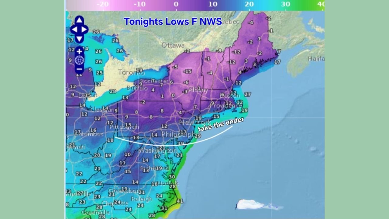
BOSTON, MASSACHUSETTS – An aggressive Arctic air mass is surging into the Northeast tonight, sending temperatures plummeting below zero across New York, Massachusetts, Vermont, and New Hampshire, with wind chills expected to feel even colder. New forecast maps show –5°F to –15°F lows across a large part of New England, and meteorologists say some locations may drop below forecasted numbers entirely.
This cold blast arrives faster and sharper than earlier predictions, with dew points crashing below zero — a sign of extremely dry, dangerous air that intensifies overnight cooling.
Temperatures Already Falling Faster Than National Weather Service Forecasts
Updated temperature models show widespread purple shading across the Northeast, indicating deep subzero temperatures settling in after sunset. Cities such as Albany, Worcester, Concord, and Burlington are already running colder than expected.
A meteorologist warned earlier today:
“Take the under on these tonight. I’m already below overnight forecasts across southern New England — and dropping fast.”
Subzero dew points across the region are accelerating radiational cooling, meaning temperatures will continue to collapse through midnight.
Residents across central and northern New England may see lows between –8°F and –15°F, while coastal areas, including Rhode Island and eastern Massachusetts, will hover in the single digits — still far below normal for early December.
New York and Pennsylvania Also Brace for Single-Digit and Subzero Lows
Western and upstate New York — including Buffalo, Rochester, Syracuse, and Albany — are forecast to drop into the –2°F to –10°F range. Even Pennsylvania’s interior counties will plunge into the single digits.
The sharp gradient between inland Arctic air and slightly milder coastal temperatures will create pockets of intense cold inland — especially in the Hudson Valley, Berkshires, and northern Connecticut.
A weather account tracking the plunge posted:
“These temps are collapsing faster than expected. Some towns may beat their coldest early-December lows in years.”
Why This Cold Shot Is So Extreme
The powerful Arctic outbreak is driven by a deep trough over the Northeast, funneling dense, frigid Canadian air southward with almost no atmospheric moisture. Dew points falling below zero across New England signal dangerously dry conditions that promote rapid evaporative cooling — allowing temperatures to free-fall even after sunset.
Meteorologists reviewing model discussions note similarities to several past Arctic outbreaks documented in Northeast climate records.
The cold is expected to remain in place until a slow warm-up next week, though nighttime lows will continue to flirt with zero for several days.
Dangerous Impacts: Frostbite Risks, Burst Pipes, and Flash Freeze Conditions
With subzero temperatures spreading across much of New England and New York, the risks increase significantly for:
- Frostbite in as little as 20 minutes
- Frozen or burst pipes in poorly insulated homes
- Dangerous overnight driving due to flash-freeze patches
- Heating system strain and power-demand spikes
- Cold-related breathing issues for vulnerable individuals
Black ice may form where afternoon melting occurred, especially on bridges, shaded roads, and untreated parking lots.
Officials are urging residents to keep faucets dripping, bring pets indoors, check on elderly neighbors, and avoid prolonged exposure outdoors.
Temperature Breakdown By Region
New England
- Massachusetts: –6°F to –12°F inland; 5°F to 12°F along the coast
- Vermont / New Hampshire: –10°F to –15°F
- Rhode Island / Connecticut: 8°F to 18°F
New York
- Upstate: –5°F to –10°F
- Hudson Valley: –2°F to –6°F
- NYC Metro: 12°F to 19°F
Mid-Atlantic Fringe
- Pennsylvania interior: 7°F to 15°F
- New Jersey: 14°F to 23°F
- Maryland: Upper teens
While coastal areas stay slightly warmer, they still fall well below seasonal averages.
When Will Relief Arrive?
Temperatures will remain dangerously cold through early Thursday morning before slowly moderating into the weekend.
Longer-range outlooks referenced in NOAA climate guidance suggest a broader warm-up may arrive mid-month — but meteorologists caution that another short-lived cold shot is possible before conditions stabilize.
Are you experiencing colder temperatures than forecast tonight? Do you think this will be one of the coldest nights of the early winter season?
Share your thoughts and join the conversation at WaldroNnews.com.