
Upper-Level Weather Pattern Over Indiana Shows Growing Potential for Weekend System, Forecasters Say
INDIANA – A Deepening Trough Over the Midwest Raises Attention Ahead of Sunday, A developing upper-level weather pattern over the Midwest is drawing increased attention across Indiana, as new atmospheric data illustrates a stronger, more organized trough expected to influence conditions heading into the weekend. The latest analysis shows a pronounced dip in the jet stream pressing southward over the Great Lakes and central United States, a setup that can help energize storm systems and enhance precipitation chances across the region.
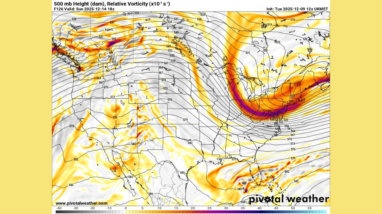
Two widely shared forecast graphics circulating among weather analysts on Tuesday highlight a sharply curved, intensifying trough extending from Canada into the Ohio Valley and Indiana area by Sunday afternoon. The imagery suggests a fast-moving, energetic system capable of shaping regional weather depending on how it aligns and slows over the next several days.
What the Upper-Level Map Shows
The 500-millibar chart — a common tool used to understand mid-atmospheric steering currents — depicts:
- A deep, sweeping trough digging southward across the Great Lakes region
- Strong pockets of vorticity, which indicate areas of atmospheric spin and rising motion
- A jet stream arc that tightens into a sharper curve as it approaches Indiana
When these features align, they can help develop stronger surface systems, increase cloud cover, and boost the likelihood of rain or even snow depending on temperatures. For the Midwest, shifts in the shape and speed of the trough often determine whether the region sees mild disturbance or a more significant weather event.
Analysts Watching for a Key Development: A More Tilted, Slower Trough
Weather analysts discussing Tuesday’s data emphasized that the orientation and speed of the trough will be the determining factors in what Indiana ultimately experiences this weekend.
One widely shared comment noted that the pattern is “not a bad look at all, just need to get more of a negative tilt aspect to the trough,” referring to a configuration where the trough angles northwest-to-southeast. When a trough tilts negatively, it can become more powerful and promote stronger storm development.
Another forecaster highlighted the importance of the system slowing down and shifting slightly westward, which would increase the odds of a more impactful weather outcome for the Midwest. If it moves too quickly or remains too far east, Indiana may see only limited effects.
Still Several Days From Clarity
Although the upper-air pattern is strengthening, analysts caution that the region is still several days away from a clear answer about precise impacts. Small adjustments in the storm track, jet stream curve, or the speed of the trough can significantly change who sees rain, a wintry mix, or nothing more than increased clouds and breezy conditions.
Sunday remains the target timeframe for when the system’s influence will be most noticeable across Indiana and surrounding states. Updated data later in the week will help refine expectations as the trough moves closer and its final shape becomes clearer.
What Indiana Residents Should Expect for Now
At this stage, the key takeaway is that a potentially influential upper-level pattern is forming, and Indiana is positioned close to its main axis. Residents should:
- Monitor local forecasts heading into the weekend
- Prepare for changing weather conditions Sunday
- Expect updates as forecasters gain confidence in the system’s track and timing
WaldronNews.com will continue to track this developing weather pattern closely and provide updates as new information becomes available.
Stay with WaldronNews.com for continuing coverage and reliable local weather updates.