
Severe Ground Blizzard Conditions Expected in Illinois as Powerful Winds Create Near-Zero Visibility Across the Midwest
ILLINOIS — A Dangerous Ground Blizzard Threatens Travel as Winds Surge to 50–70 mph, A rapidly intensifying wind event is expected to create dangerous ground blizzard conditions across Illinois and much of the Midwest tonight and into Wednesday, as widespread wind gusts ranging from 50 to 70 mph sweep across the region. Even though little to no new snow is forecast, the existing snowpack on the ground is expected to become airborne, producing whiteout conditions, sudden drops in visibility, and extremely hazardous travel.
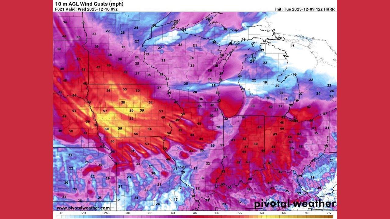
Forecast graphics reviewed Tuesday highlight a corridor of intense wind gusts stretching from South Dakota and Minnesota through Iowa and into Illinois, with the strongest gusts exceeding 60 mph in some areas. These high winds will be capable of lifting loose snow from the ground, creating a true ground blizzard — a phenomenon in which visibility can fall to near zero despite no snowfall occurring overhead.
Residents and travelers across Illinois should prepare for rapidly changing conditions, especially overnight and during the Wednesday morning commute.
Strong Winds Will Create Hazardous Travel and Sudden Whiteouts
Wind analysis maps show a broad zone of red to bright yellow shading centered over Iowa and Illinois, indicating peak gusts between 55 and 70 mph. These values are strong enough to:
- Produce instant whiteout conditions
- Blow snow across highways, reducing visibility to a few feet
- Cause hazardous travel on north–south roads
- Create snowdrifts across rural and open areas
- Lead to scattered power outages and falling tree branches
Drivers may encounter conditions that deteriorate within seconds, especially in open fields and rural stretches where snow can move freely.
Even areas with only a thin snow cover will be vulnerable, as powerful winds can easily loft powdery snow back into the air.
Most Impacted Regions and Timing
Based on the latest data, the most severe impacts are expected across:
- Northern and Central Illinois
- Eastern Iowa
- Southern Minnesota
- Eastern South Dakota
In Illinois, the strongest gusts appear likely from late Tuesday night through mid-morning Wednesday, with some locations experiencing wind gusts above 60 mph.
Ground blizzard conditions will be most intense where snowpack is deep and winds funnel across flat terrain, creating prolonged visibility issues and dangerous travel corridors.
Even Without New Snowfall, Conditions Will Become Life-Threatening
One of the most dangerous aspects of a ground blizzard is that it can mimic a major snowstorm despite no fresh accumulation.
The combination of strong winds and loose snow already on the ground can create:
- Zero-visibility conditions
- Hazardous or impossible travel
- Road closures in rural areas
- Blinding snow curtains blown across highways
Officials typically urge travelers to avoid driving during ground-blizzard conditions unless absolutely necessary. Motorists who must be on the road should expect sudden whiteouts and be prepared for emergency delays.
Residents Urged to Use Extreme Caution
Because the storm’s danger comes from wind rather than snowfall, many residents may underestimate the severity of the situation. Illinois residents should consider:
- Delaying non-essential travel
- Keeping emergency kits in vehicles
- Securing loose outdoor items
- Preparing for possible power disruptions
Conditions will begin improving later Wednesday as winds gradually weaken.
Stay with WaldronNews.com for ongoing updates, local alerts, and safety information as this dangerous weather event unfolds.