
Maryland Weekend Snow Chances Depend on Jet Stream Pattern as Forecast Shows Energy Failing to Merge
MARYLAND — Jet Stream Setup Could Limit Snow Potential Unless Atmospheric Energy Merges, A new round of forecast analysis shows that Maryland may see another round of weekend snow, but a larger or more significant storm will only develop if two branches of the jet stream come together — something current data suggests is unlikely.
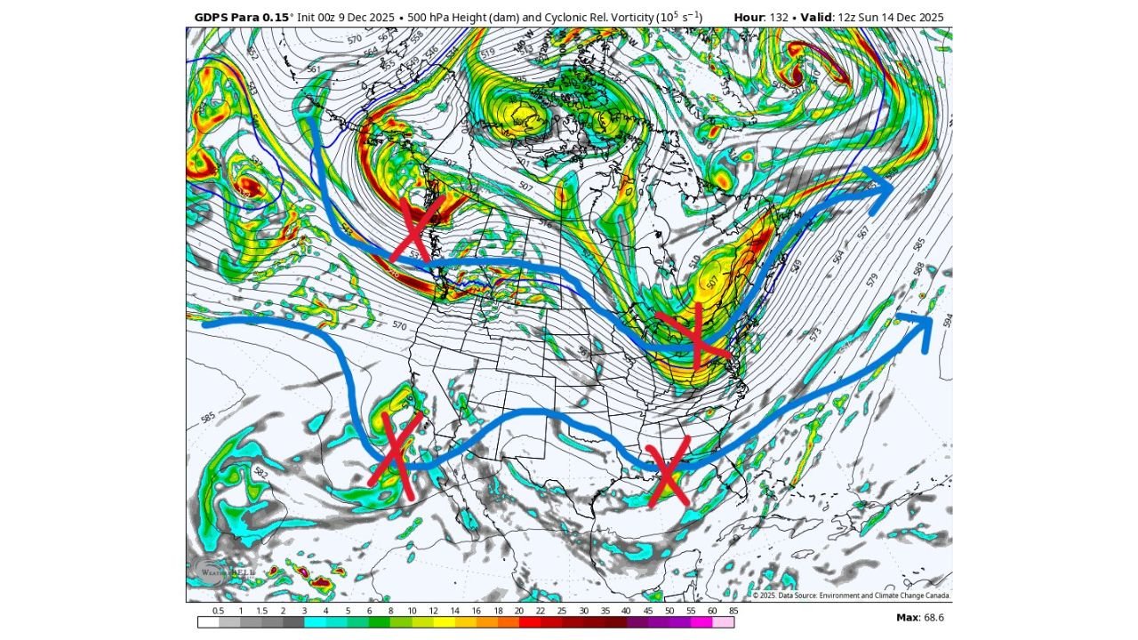
Weather experts reviewing upper-air maps for Sunday, December 14, highlight a familiar challenge for the Mid-Atlantic: the northern and southern jet streams are not phasing, meaning their energy remains separated. When both streams merge, storms along the East Coast often intensify dramatically. Without that merging, storms tend to stay weaker and produce lighter snowfall.
The latest forecast visuals depict multiple areas of atmospheric energy — marked in red by analysts — but none appear to be aligning in a way that would support a major system for Maryland.
How Jet Stream “Phasing” Works
Maryland’s biggest winter storms historically come from a specific setup:
- A northern jet stream disturbance slides down from Canada
- A southern jet stream disturbance rises from the Gulf or Pacific
- The two meet near the East Coast, amplifying each other
When this happens, the atmosphere becomes more efficient at producing moisture, lift, and storm development — often resulting in heavy snow.
But when the streams run separately, the region usually experiences smaller, weaker storms, which is what forecasters have observed recently.
What the Latest Maps Reveal
The images provided show the United States covered by two sweeping branches of upper-level winds:
- Northern Branch: A stronger belt of energy dipping across the Great Lakes and Mid-Atlantic
- Southern Branch: A broader flow crossing the Southwest and Gulf states
Red X’s on the map point to energy pockets that could spark a stronger storm if they aligned. But the current setup shows them staying disconnected, each following its own path.
Without alignment, the storm expected this weekend will likely remain modest as it passes near Maryland and the surrounding states.
What This Means for Snow in Maryland
Even with the jet streams not merging, Maryland still has the potential for light snowfall this weekend. However:
- A major winter storm is not expected under the current pattern
- Snowfall totals will likely remain limited
- Impacts should be relatively manageable
- The highest chances for accumulation will occur north and west of Baltimore
If the streams unexpectedly begin to merge later in the week — a rare but possible shift — the snow threat could increase. For now, forecasters consider that scenario unlikely based on available data.
Maryland Residents Should Still Monitor Updates
While this weekend’s storm is expected to be a minor one, jet stream patterns can shift quickly. Even small changes in upper-air energy can affect:
- Timing of snowfall
- Amount of moisture available
- Track of the system as it approaches the Mid-Atlantic
Local residents should continue checking updated forecasts as the system approaches, especially if planning weekend travel.
Stay with WaldronNews.com for ongoing analysis and updates on Maryland’s winter weather trends.