
Alabama, Georgia, Mississippi, and the Deep South Expected to See Above-Normal Temperatures December 18–24 as CPC Outlook Signals No Chance for a White Christmas
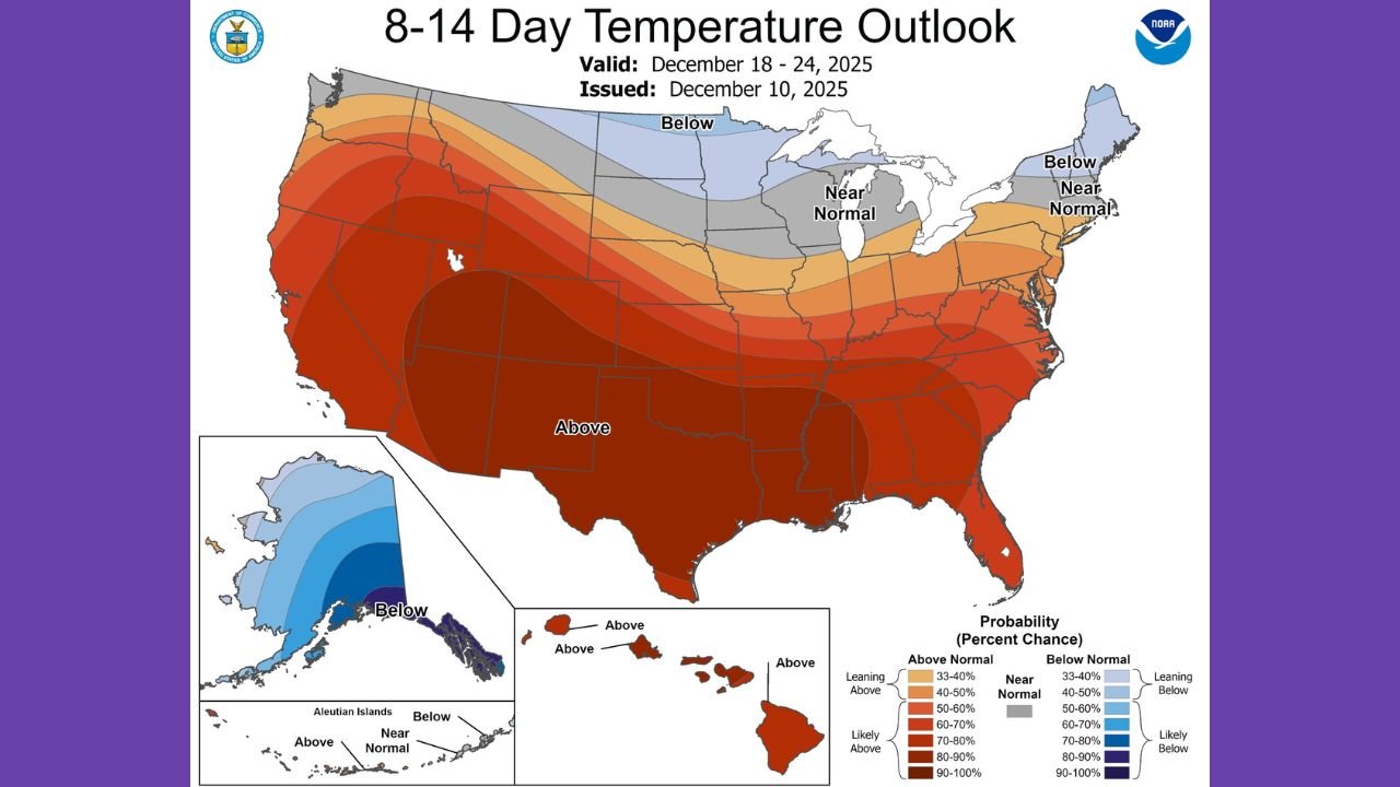
ALABAMA — New long-range guidance from the Climate Prediction Center (CPC) shows the Deep South trending much warmer than normal between December 18 and December 24, sharply reducing the odds of any Christmas-week snowfall across Alabama, Georgia, and Mississippi. The newly issued 8–14 Day Temperature Outlook highlights a pronounced warm pattern developing across the southern United States, signaling a strong flip away from the colder conditions seen earlier this month.
Warm Pattern Dominates Deep South Ahead of Christmas
The CPC map released December 10 shows a widespread 60%–90% probability of above-normal temperatures across the Deep South, including nearly all of Alabama. This setup heavily favors warmer-than-average afternoons and mild nights through Christmas Eve.
Meteorologists note that while Christmas Day snow is already rare in Alabama — with the historic 2010 snowstorm being one of the only exceptions — this year’s temperature pattern makes any chance of a white Christmas even less likely.
The CPC highlights a broad warm ridge stretching from Texas to the Carolinas. Meanwhile, cooler-than-normal air is forecast to remain locked across the northern tier of the United States and parts of the Great Lakes. This split pattern significantly limits the ability for southern storm systems to interact with cold air — a requirement for snow in the Deep South.
Why the Pattern Flip Matters
This upcoming warm stretch marks a notable shift from the colder, stormier pattern earlier in December. The CPC outlook suggests the jet stream will realign, pulling mild Pacific air over the southern half of the country beginning around December 18.
This shift reduces the chances of Arctic air masses dipping far enough south to support winter weather.
Forecasters note:
- Alabama and Georgia show one of the strongest warm anomalies in the nation
- Mississippi and the Florida Panhandle are also firmly in the “Above Normal” zone
- The Deep South will spend the week before Christmas under a warm, stable air mass unfavorable for snow
What Residents Should Expect
For holiday travelers and planners, the temperature outlook provides a fairly clear expectation:
- Afternoon highs will likely run 10–20 degrees above normal
- Nights will feel milder and frost-free in many areas
- Storm systems tracking through the region will be rain-dominated, not snow-producing
- No major cold intrusions are expected before December 24
While short-term forecasts always remain subject to last-minute changes, long-range data overwhelmingly favors milder weather leading into Christmas.
Snow Lovers in the South May Have to Wait
For those hoping for a rare Alabama white Christmas, the CPC outlook leaves little room for optimism this year. A warm pattern, lack of cold air supply, and an inactive southern storm track all point toward a snow-free holiday week across the Deep South.
However, meteorologists stress that winter is far from over. January and February historically deliver the strongest winter weather events for the region.
Stay tuned to WaldronNews.com for updated temperature outlooks, travel forecasts, and winter weather developments across the South.