
Connecticut, Rhode Island, Massachusetts, and Long Island Expected to See Overnight Snowfall of 1–6 Inches as Narrow Band Spreads Across the Northeast
NORTHEAST — A narrow but fast-moving band of snow is expected to sweep across Connecticut, Rhode Island, southeastern Massachusetts, and Long Island tonight into early Sunday morning, bringing a widespread 1–3 inches of accumulation, with pockets reaching 3–6 inches in coastal areas.
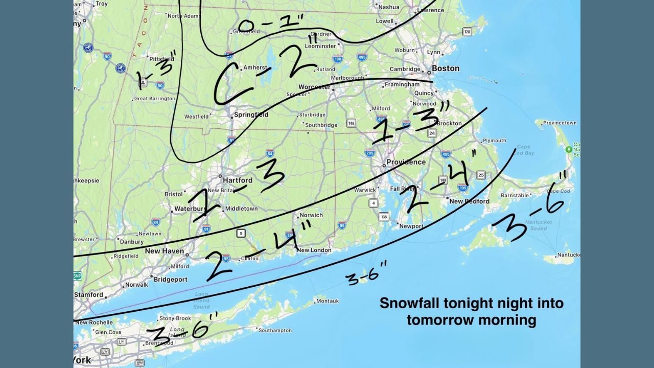
Updated snowfall maps released late Saturday show a sharp gradient across the region, with heavier totals concentrated along the shoreline and across southern New England. A Winter Weather Advisory is now in effect for parts of Connecticut, Rhode Island, southern Massachusetts, and the East End of Long Island.
Snowfall Forecast Highlights
Based on the latest mapped projections:
Connecticut
- Hartford / Central CT: 1–3 inches
- New Haven to New London corridor: 2–4 inches
- Danbury / Waterbury: 1–3 inches
Rhode Island
- Providence region: 1–3 inches
- *Southern RI (Newport / South County): 2–4 inches
Massachusetts (Southeast & Cape Region)
- Brockton / Plymouth: 1–3 inches
- New Bedford / Fall River: 2–4 inches
- Cape Cod & Islands: 3–6 inches possible
Long Island
- Nassau / Western Suffolk: 2–4 inches
- Central–Eastern Suffolk (Islip, Stony Brook, Riverhead): 3–6 inches
This aligns with the broader radar trends showing the snow shield advancing from Pennsylvania, New York, and New Jersey toward southern New England.
Winter Weather Advisories Issued Across the Region
A multi-state advisory zone now covers:
- Southern Connecticut
- Rhode Island
- Southeastern Massachusetts
- Long Island’s North and South Shores
These alerts emphasize the likelihood of slick roads, reduced visibility, and hazardous travel conditions through early Sunday morning.
Storm Setup: Narrow Band Producing Sharp Snow Gradients
The snowfall forecast indicates a classic Northeast setup:
- A southwest-to-northeast oriented snow band stretches from Ohio and Pennsylvania through New Jersey and into southern New England.
- Areas just outside the core band may see only a coating to 1 inch, while locations along the southern boundary could pick up 3–6 inches quickly.
- Snowfall is expected to be fluffy and fast-accumulating, given surface temps near freezing and cold air aloft.
Meteorologists caution that these bands can shift slightly north or south, creating tighter gradients and causing some areas to overperform or underperform relative to the forecast.
Travel Outlook
Drivers across I-95, I-91, and the southern Massachusetts corridor should expect:
- Reduced visibility
- Rapid accumulation on untreated roads
- Slippery conditions during the early morning hours
Snowfall is expected to taper off shortly after daybreak on Sunday.
What’s Next
No major follow-up storms are flagged for immediate arrival, but temperatures will remain seasonal with the potential for additional light disturbances mid-week.
Waldron News will continue to monitor any shifts in the storm track overnight.