
California, Oregon, and Washington Face Potential Christmas Eve West Coast Storm as Forecast Models Signal Developing Pacific System
UNITED STATES — Forecast models are beginning to flag the potential for a strong Pacific storm to ride up the West Coast on Christmas Eve, placing California, Oregon, and Washington on alert for a possible period of heavy rain, strong winds, and mountain snow. While confidence remains limited this far out, meteorologists say the signal is notable enough to warrant close monitoring over the coming days.
“There’s still a lot of uncertainty, but this is not the timing anyone wants to see a storm — especially with holiday travel underway.”
What the Models Are Showing Right Now
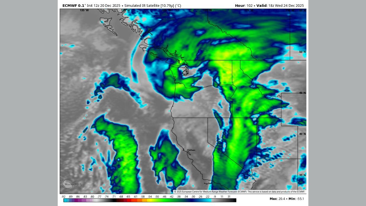
Longer-range guidance, including simulated satellite imagery, depicts a large, organized moisture plume approaching the Pacific Coast around Wednesday, December 24. The system appears capable of tapping into deep Pacific moisture, a setup that can enhance rainfall intensity once it reaches land.
At this stage:
- The storm’s exact track and strength are not locked in
- Small shifts could significantly change who sees the heaviest impacts
- Confidence is moderate to low, but increasing
Forecasters stress that early model agreement does not guarantee a high-impact outcome — but it does raise the odds of a meaningful weather event.
Potential Impacts by Region if the System Strengthens
If current trends hold, impacts could include:
California
- Periods of moderate to heavy rain, especially in coastal and northern areas
- Mountain snow in the Sierra Nevada
- Localized flooding possible in poor-drainage or burn-scar locations
Oregon
- Widespread rain along the coast and valleys
- Increasing winds, particularly along exposed headlands
- Snow developing in the Cascades
Washington
- Rain and gusty winds along the coast and lowlands
- Snowfall in the Cascades, with potential travel impacts over mountain passes
“It’s the overall structure that stands out — this is not just a weak, disorganized system on the models.”
Why Forecast Confidence Is Still Limited
Several key details remain unresolved:
- How quickly the storm intensifies offshore
- Whether it tracks closer to the coast or remains farther west
- The timing of peak impacts relative to Christmas Eve travel
Even small changes in the upper-level pattern could mean lighter rain instead of heavy totals, or strong winds arriving earlier or later than expected.
What Happens Next
Meteorologists will be watching:
- Model consistency over the next 48–72 hours
- Trends in storm organization and moisture transport
- Signs of stronger wind fields or enhanced rainfall potential
Clarity should improve as the system moves closer and enters higher-resolution forecast windows.
Bottom Line
A potentially impactful Pacific storm could affect California, Oregon, and Washington on Christmas Eve, but uncertainty remains high. While it is far too early for specific warnings, the pattern is one that deserves attention — particularly for those planning holiday travel or outdoor activities.
Stay with WaldronNews.com for continued updates as confidence improves, and share how conditions look in your area as the Christmas week forecast comes into sharper focus.