
Tennessee, Arkansas and Mississippi Face 30% Tornado Corridor Monday as All Hazards Converge on Mid-South Bull’s-Eye
MEMPHIS, Tennessee — Confidence is rapidly growing that Monday, April 27 will bring a significant and dangerous severe weather outbreak across the Mid-South, with Tennessee, Arkansas, and Mississippi locked in as the core bull’s-eye zone. Every major atmospheric data set is now converging on the same target area — a corridor where damaging winds, large hail, and tornadoes are all expected, and where a 30% tornado probability corridor could be formally issued in the next outlook update.
The setup driving this threat — a negatively tilted trough, extremely high wind shear, and a deeply unstable atmosphere — is the kind of combination that produces not just tornadoes, but significant, long-track tornadoes. Forecasters are paying close attention.
States and Cities in the Bull’s-Eye
- Tennessee: Memphis, Jackson — sitting directly inside the red-circled bull’s-eye zone where all atmospheric ingredients overlap most dangerously
- Arkansas: Little Rock, Jonesboro, West Memphis — inside the core risk corridor; high shear values confirmed over this area
- Mississippi: Tupelo, Corinth, Oxford — northern Mississippi pulled into the primary threat zone
- Kentucky: Paducah, western portions — on the northern edge of the convergence zone
- Missouri: Sikeston, Bootheel region — caught in the outer ring of the developing threat
- Alabama: Huntsville and northern counties — southeastern fringe of the bull’s-eye
Primary Threats
- Tornadoes — the leading concern given the negatively tilted trough and extreme wind shear; significant tornadoes cannot be ruled out in the core zone
- Damaging straight-line winds — all hazards expected; wind damage will be widespread even outside the tornado threat area
- Large hail — supercells developing ahead of the front will produce hail in addition to wind and tornado threats
- 850mb wind shear exceeding 40 knots — confirmed across the bull’s-eye zone, providing the rotational energy needed for supercell development and tornado production
- A 30% tornado probability corridor is being flagged as a realistic outcome for the next formal outlook update covering this area
Why This Matters for Tennessee and Arkansas
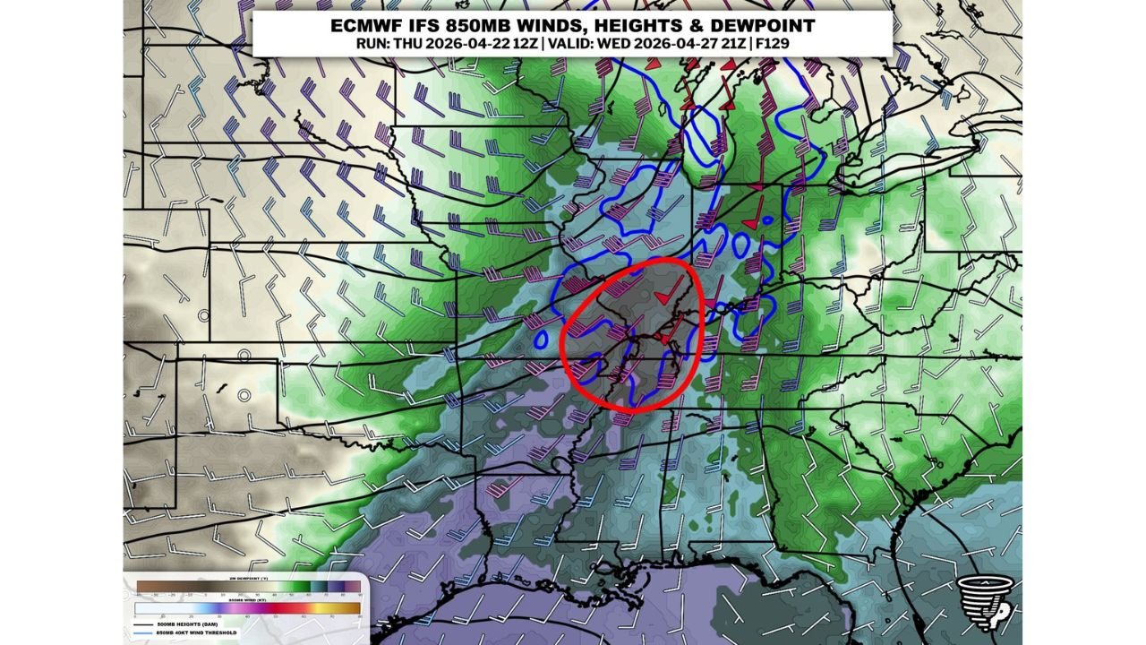
The atmospheric map for Monday, April 27 at 9 PM tells a very specific story. The 850mb wind field — the layer of the atmosphere about a mile above the ground where low-level wind shear does its most dangerous work — is surging directly into a zone centered over Memphis, West Memphis, and the surrounding Arkansas-Tennessee border region. That is where the red circle lands. That is where every data set is pointing.
A negatively tilted trough is the key phrase here. When an upper-level weather system tilts in this direction as it approaches, it releases atmospheric energy rapidly and aggressively. It accelerates storm development, intensifies wind shear, and dramatically increases the chance of rotating supercells. Paired with a very unstable atmosphere already loaded with Gulf moisture, the result is an environment where organized, long-track tornadoes become a realistic threat — not just a marginal possibility.
Arkansas has not seen a setup like this so far this spring. Memphis and western Tennessee are in the same quiet stretch the rest of the Mid-South has experienced. That extended quiet makes Monday’s event more dangerous, not less — the atmosphere has had weeks to build up energy, and Monday is when it releases.
Multi-Day Pattern
Monday does not stand alone. It is the first major release valve in a pattern that has been building pressure across the Deep South for weeks. After Monday’s system pushes through, a brief lull is possible Tuesday — but another organized severe weather setup is already being flagged for Thursday, May 1 across Mississippi, Alabama, and Louisiana. The Mid-South is entering a multi-event severe weather stretch, and Monday is Round One.
The atmosphere over this region for the next 10 days resembles what forecasters see in the most active springs on record for the Tennessee Valley and Lower Mississippi Valley. Back-to-back significant setups within the same week are rare but not unprecedented — and this spring appears to be building toward exactly that.
What to Watch Next
- A 30% tornado probability formal designation for the Memphis-to-Paducah corridor could be issued within hours — check for updated outlooks today and tonight
- Monday storms are expected during the afternoon and evening — but could push into overnight hours for parts of Mississippi and Alabama, when tornadoes are most deadly
- The negatively tilted trough means storm intensification could be rapid — conditions can go from cloudy to tornado warning in a very short window
- Arkansas residents east of Little Rock through the Missouri Bootheel should treat this as a high-priority threat, not a peripheral one
- Identify your tornado shelter right now — do not wait until Monday morning when warning lead times shrink fast
Residents across Tennessee, Arkansas, and Mississippi are facing one of the most concentrated severe weather setups of the spring — and the window to prepare is closing fast.
WaldronNews.com will continue tracking Monday’s severe weather threat and provide updates as the outlook is refined throughout the day.