
Kansas, Oklahoma and Nebraska Face EF2+ Tornado Risk Today as Two Dangerous Storm Zones Target Wichita and Oklahoma City
WICHITA, Kansas — Two distinct and dangerous storm zones are taking shape across the Central Plains today, with eastern Kansas, northeastern Oklahoma, and central/southern Oklahoma both carrying serious tornado potential as a cold front and dryline collide across the region. Wichita, Kansas sits at the heart of the higher-confidence threat zone, while Oklahoma City faces a conditional but potentially explosive severe weather situation if the atmospheric cap breaks this afternoon.
Scattered severe storms are expected from the Central Plains all the way up through the Upper Midwest, but the tornado threat is concentrated in two very specific corridors that demand the closest attention today.
Two Zones — Two Different Threats
Zone 1 — Eastern Kansas and Northeastern Oklahoma (Higher Confidence):
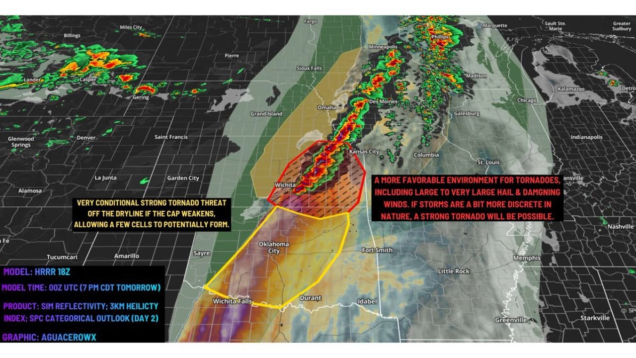
- Kansas: Wichita, Emporia, Chanute — more favorable tornado environment with better atmospheric forcing and little to no cap holding storms back
- Oklahoma: Tulsa, Bartlesville, Miami — northeastern Oklahoma pulled into this zone
- EF2+ tornadoes are possible if storms remain semi-discrete rather than merging into a line
- Large to very large hail and damaging winds alongside the tornado threat
Zone 2 — Central and Southern Oklahoma (Conditional but Explosive):
- Oklahoma: Oklahoma City, Lawton, Ardmore, Wichita Falls area — much higher instability and shear available, but a strong cap currently holding storms back
- If the cap weakens or breaks off the dryline this afternoon, supercells could explode rapidly and become significant large hail and strong tornado producers
- Nebraska: Grand Island, Omaha corridor — damaging wind threat along the cold front
- Iowa: Des Moines area — large hail and damaging winds as the front pushes northeast
Primary Threats
- EF2+ tornadoes — possible in eastern Kansas and northeastern Oklahoma where the cap is absent and forcing is favorable; semi-discrete storm mode is the key factor
- Very large hail — both zones carry significant hail potential; central Oklahoma supercells could produce especially large stones if they fire
- Damaging straight-line winds — the cold front pushing through Nebraska, Iowa, and into the Upper Midwest brings a widespread wind damage threat even outside the tornado zones
- Cap break watch — the single most important variable today is whether the atmospheric cap over central Oklahoma weakens enough to allow storms to initiate off the dryline; if it does, the threat level escalates rapidly
Why This Matters for Kansas and Oklahoma
Wichita is in the worst possible position today — sitting at the overlap between the cold front and the area where tornado forcing is strongest. The absence of a significant cap here means storms can fire without needing to wait for the atmosphere to break — they will develop when the trigger arrives, and they will have everything they need to produce tornadoes immediately.
The situation in Oklahoma City is different but potentially more dangerous if things go wrong. Central and southern Oklahoma have more raw atmospheric fuel available — more instability, more wind shear — than the Kansas zone. The only thing standing between a quiet afternoon and a violent tornado outbreak is a strong atmospheric cap that is currently suppressing storm development. Caps are not permanent. They weaken as the day heats up, as the dryline pushes east, and as upper-level energy approaches. If that cap cracks this afternoon, supercells could develop explosively and have access to one of the most volatile atmospheric environments seen across Oklahoma this spring.
This is exactly the kind of setup that has produced some of the most destructive tornado days in Oklahoma history — a loaded atmosphere held down by a cap, waiting for one crack to let everything loose at once.
Multi-Day Pattern
Today’s event is not isolated. It follows the broader active pattern that has been building across the Plains and Mid-South all week. After today’s storms clear, attention immediately shifts to Monday, April 27 when the Mid-South — Tennessee, Arkansas, and Mississippi — faces its own significant tornado threat. The atmosphere is cycling through back-to-back dangerous setups with very little recovery time between events.
For Kansas and Oklahoma, today is the sharpest local threat. But the Plains remain unsettled into next week as the larger pattern continues delivering storm systems across the region.
What to Watch Next
- Monitor cap break timing across central Oklahoma this afternoon — if storms fire off the dryline, the threat level escalates immediately
- Wichita and eastern Kansas residents should be in shelter-ready mode for the full afternoon and evening hours
- Storm mode is everything today — discrete supercells mean tornado threat, while a merged squall line shifts the primary threat to straight-line winds
- Watch the Nebraska and Iowa corridor for damaging wind gusts along the cold front through the afternoon
- If you are in Oklahoma City or south of there, do not assume the cap holds — have your shelter plan ready before noon
Residents across Kansas, Oklahoma, and Nebraska need to treat today as an active severe weather day from start to finish — the ingredients for a dangerous outbreak are all in place.
WaldronNews.com will continue tracking today’s severe weather and provide updates as storms develop across the Plains this afternoon and evening.