
Mississippi, Alabama and Louisiana in the Crosshairs as Major Severe Weather Signal Emerges for Thursday May 1
JACKSON, Mississippi — A powerful and unusually consistent long-range signal is pointing toward a significant severe weather event across the Deep South around Thursday, May 1 — and Mississippi, Alabama, and Louisiana are sitting directly in the bull’s-eye. Multiple atmospheric data sets are in strong agreement on a southern trough digging into the region for this timeframe, a setup that combines dangerous instability, wind shear exceeding 40 knots, and storm energy sufficient to produce organized severe thunderstorms.
This event is still more than a week away and details will evolve — but the consistency of the signal at this range is not something forecasters typically see, and it is drawing serious attention.
States in the Emerging Risk Zone
- Mississippi: Jackson, Hattiesburg, Meridian — sitting near the center of the highest severe weather probability overlap on the map
- Alabama: Birmingham, Tuscaloosa, Mobile — inside the core severe weather parameter overlap zone
- Louisiana: Baton Rouge, Shreveport, New Orleans — strong signal extending across the state
- Arkansas: Little Rock corridor — on the northern fringe of the developing threat
- Tennessee: Memphis and southwestern portions — caught in the outer edge of the setup
- Georgia: Western portions including Atlanta suburbs — inside the broader threat area as the trough extends east
Primary Threats
- CAPE values exceeding 500 J/kg combined with wind shear above 40 knots and active convective rainfall — the three ingredients that together define the highest-end severe weather environments
- Upper-level jet stream winds reaching 105–115 knots directly over the Deep South — extreme wind energy available to tilt and organize severe thunderstorms
- Southern trough digging into the Gulf Coast states — a classic pattern for widespread, organized severe weather across Mississippi, Alabama, and Louisiana
- A 15% or greater risk designation from formal outlooks could be issued for this event in the coming days as confidence continues building
Why This Matters for Mississippi and Alabama
The atmosphere over the Deep South has been unusually quiet this spring. Mississippi and Alabama have gone weeks without significant severe weather — an anomaly for this time of year. When a pattern finally flips after a long quiet stretch, the first active event tends to catch people off guard. That is the exact situation setting up for Thursday, May 1.
What makes this signal stand out is the triple overlap visible on the probability maps. Separately, high instability, strong wind shear, and active storm coverage each mean something. When all three align over the same area on the same day — centered directly over Jackson, Mississippi and Birmingham, Alabama — that is the atmospheric fingerprint of a serious severe weather day.
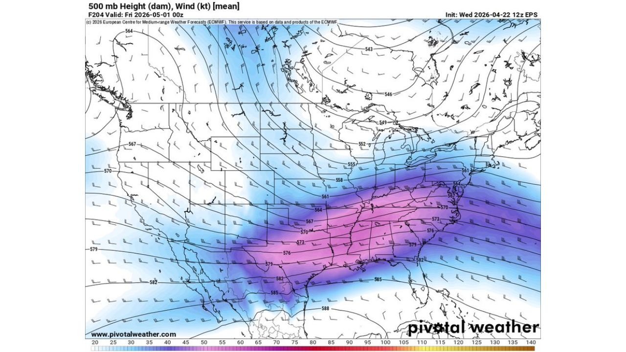
The upper-level wind speed map tells the other half of the story. A powerful jet stream is forecast to be roaring directly over the Deep South at 105 to 115+ knots by May 1, providing the overhead energy that allows thunderstorms to grow tall, organize into supercells, and produce damaging winds and tornadoes. The purple-to-pink shading on the wind speed map covering Mississippi, Alabama, Louisiana, and into the Carolinas represents one of the stronger upper-level setups seen over this region in recent weeks.
Multi-Day Pattern
The week leading up to May 1 is not quiet. Monday, April 27 already carries its own significant tornado threat across the Mid-South, and the atmosphere barely pauses before the next round loads up. The southern trough responsible for the May 1 signal appears to be a deeper, more organized system than what arrives Monday — meaning the second round could outpace the first in terms of overall severe weather potential.
After May 1, ensemble data suggests the active pattern continues. The Deep South and Southeast appear locked into a multi-week stretch of elevated storm potential, consistent with what longer-range data has been showing for the April 29 through May 6 window where supercell composite values peak across this same region.
What to Watch Next
- Watch for formal severe weather outlooks to be issued for May 1 within the next 72–96 hours as the event comes into range
- Mississippi and Alabama residents should treat this as a two-event week — Monday April 27 and Thursday May 1 both demand preparation
- The Louisiana coast and Baton Rouge corridor are more directly threatened by this round than by Monday’s event — pay close attention
- Upper-level wind data will sharpen in coming days — if jet stream positioning holds, this could be one of the stronger setups of the spring
- Nighttime storm timing is possible for portions of Alabama and Mississippi — finalize shelter plans well before Thursday arrives
Residents across Mississippi, Alabama, and Louisiana are facing a two-punch severe weather week — and the second punch on Thursday, May 1 may be the harder of the two.
WaldronNews.com will continue tracking this developing threat and provide updates daily as the May 1 severe weather signal sharpens.