
Potentially Historic Lake-Effect Snow Targets Central New York as HRRR Shows Up to 57 Inches Northwest of Syracuse, New York
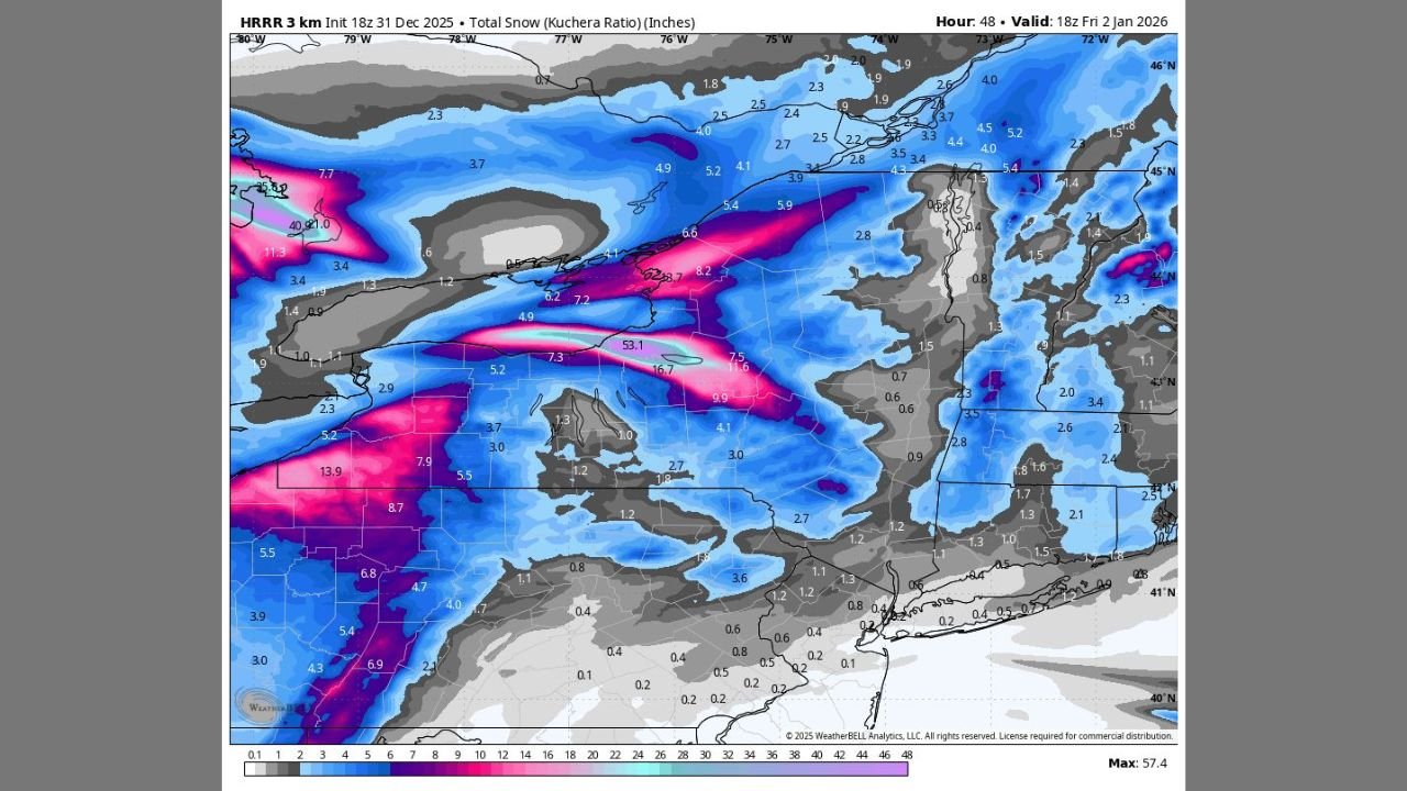
NEW YORK — Newly analyzed high-resolution forecast data shows a potentially extreme lake-effect snow event taking shape across central New York, with areas northwest of Syracuse at risk for historic snowfall totals over the next 48 hours. Model guidance indicates intense, persistent snow bands developing off Lake Ontario, capable of producing exceptional accumulations, dangerous travel conditions, and isolated thundersnow, as cold air continues to pour across the region.
Lake-Effect Snow Bands Shifting Back Into the Lake Ontario Snowbelt
After the heaviest snowfall focused south of Buffalo earlier, meteorologists say the dominant lake-effect band is expected to reorganize and shift northeastward, placing the Lake Ontario snowbelt back in the crosshairs later today and continuing through Friday. Forecast models show the most intense band aligning from Oswego County into portions of Cayuga and Onondaga counties, with snowfall rates strengthening as colder air deepens over the lake.
Once established, the band is expected to remain relatively stationary for extended periods — a key factor that dramatically increases accumulation potential.
HRRR Model Signals Extreme Snowfall Potential Near Syracuse
The high-resolution HRRR model is indicating localized snowfall totals exceeding 50 inches in a narrow corridor northwest of Syracuse over a 48-hour period. While forecasters caution that exact placement of the heaviest band can still shift, confidence is increasing that at least one community in the Lake Ontario snowbelt could see truly exceptional totals.
Snowfall rates within the strongest band may reach 2 to 5 inches per hour, with brief bursts even higher during peak intensity. These conditions significantly increase the risk of near-zero visibility, rapidly snow-covered roads, and whiteout conditions.
Thunder and Lightning Possible Within the Snow Band
Forecast guidance also suggests the potential for thundersnow, a rare but dangerous phenomenon that occurs when strong atmospheric instability develops within lake-effect bands. Thundersnow typically coincides with the most intense snowfall rates, further reducing visibility and making travel extremely hazardous.
Residents may experience sudden, severe bursts of snow with little warning as the band oscillates.
Major Travel Impacts Expected Across Central New York
Transportation officials warn that travel could become impossible at times, particularly during overnight and early morning hours. Roads may go from wet to snow-covered within minutes under the strongest snowfall rates, and frequent whiteout conditions could lead to road closures.
Areas most vulnerable include:
- Oswego County
- Northern Cayuga County
- Northern Onondaga County
- Communities northwest of Syracuse
Even locations just a few miles outside the primary band may see drastically lower totals, highlighting the highly localized nature of this event.
Cold Air Keeps Lake-Effect Machine Running
The prolonged nature of this storm is being fueled by a deep influx of arctic air crossing the relatively warm waters of Lake Ontario. This temperature contrast allows lake-effect processes to remain active for multiple days, with only minor shifts in wind direction capable of relocating the heaviest snow.
Forecasters note that conditions may briefly weaken at times but are expected to re-intensify repeatedly through Friday.
Residents Urged to Prepare for Rapidly Changing Conditions
Emergency officials urge residents in the Lake Ontario snowbelt to avoid unnecessary travel, keep emergency supplies stocked, and remain alert to updated warnings. Power outages are also possible in areas where heavy, wind-driven snow accumulates on infrastructure.
Even experienced winter drivers are warned that conditions during peak snowfall may exceed what plows can keep up with.
This developing lake-effect snow event is expected to remain highly dynamic, with small shifts in wind direction making a major difference in who sees the heaviest snow. Residents across central New York are urged to stay weather-aware as this potentially historic storm unfolds.
Stay with Waldron News for continuous updates, safety alerts, and local coverage as conditions change across New York.