
California Storm Threatens Southern California With Flash Flooding and Landslides as Heavy Rain Targets Burn Scar Areas
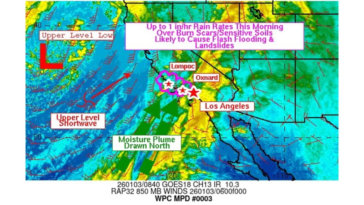
CALIFORNIA — A powerful storm system moving into Southern California is raising serious concerns for flash flooding and landslides, particularly in areas impacted by recent wildfires. Meteorologists warn that intense rainfall rates approaching 1 inch per hour could overwhelm sensitive soils, especially across burn scar zones in Los Angeles, Ventura, and Santa Barbara counties.
Heavy Rain Focused on Burn Scar Regions
Forecast data shows a deep moisture plume being drawn northward into Southern California as an upper-level low and shortwave disturbance move inland. This setup is expected to produce bands of heavy rain, with the most intense precipitation likely to develop during the morning and early afternoon hours.
Burn scar areas are especially vulnerable because vegetation that normally stabilizes hillsides has been removed. As a result, even short bursts of heavy rain can trigger rapid runoff, debris flows, and mudslides, creating dangerous conditions near foothills, canyons, and low-lying roads.
Flash Flooding and Landslide Risk Increasing
Rainfall rates nearing 1 inch per hour are considered sufficient to cause flash flooding, particularly in urban areas with poor drainage. Officials caution that creeks, small rivers, and normally dry washes could rise quickly with little warning.
Landslide and debris flow risks are highest near recent wildfire burn scars, where soils repel water and runoff accelerates downhill. Residents in these areas are urged to remain alert and prepared to move to higher ground if warnings are issued.
Travel Impacts and Safety Concerns
The storm could lead to dangerous travel conditions, including flooded roadways, rockslides, and sudden closures along highways that pass through mountain passes and canyon corridors. Emergency officials stress that motorists should never drive through flooded roads, as water depth and road damage can be difficult to judge.
Power outages are also possible if saturated soils cause trees or utility poles to fall, especially in areas experiencing gusty winds alongside heavy rain.
Timing and What to Expect Next
The heaviest rainfall is expected to occur during the peak of the storm as moisture bands train over the same locations, increasing the risk of flooding. Conditions should gradually improve as the system weakens and moves east, but lingering showers may continue in some areas.
Residents are encouraged to monitor local alerts, weather warnings, and evacuation notices, particularly if they live near hillsides, burn scars, or flood-prone zones.
Stay informed and prepared as this Southern California storm unfolds. Follow the latest updates and share your local conditions with us by visiting WaldronNews.com, where we continue to track developing weather threats and safety impacts across the region.