
Rare Lakeshore Snow Band Dumps Up to 26 Inches in Central New York as Lake Ontario Lake-Effect Intensifies Near I-81
NEW YORK — A high-impact lake-effect snow event delivered exceptionally heavy snowfall along the immediate Lake Ontario shoreline in central New York, defying typical patterns as a narrow but intense snow band set up west and just east of Interstate 81, burying parts of Oswego County and northern Onondaga County under deep accumulations. Observations confirmed up to 26 inches of snow in Selkirk Shores, an unusually high total for locations right along the lakeshore.
Why This Snowfall Was So Unusual
Lake-effect snow events often peak farther inland, where wind shear, graupel mixing, or directional shifts weaken snowfall rates closer to the shore. In this case, however, a persistent and well-aligned band remained anchored near the shoreline for hours, allowing snowfall rates to remain intense rather than breaking apart.
Meteorologists noted that wind direction and stability over Lake Ontario were nearly ideal, limiting disruption and allowing the band to repeatedly target the same communities instead of oscillating inland.
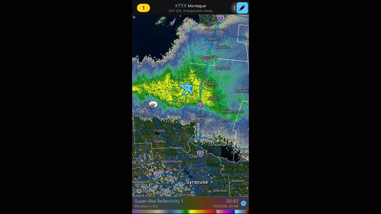
Heaviest Snowfall Focused Near I-81 Corridor
Radar imagery and surface reports showed the strongest reflectivity concentrated near and just west of the I-81 corridor, extending from areas near Oswego through Richland, Parish, and portions of northern Onondaga County. This placement is significant, as wind-driven mixing west of I-81 often weakens bands, but that did not occur during this event.
The result was prolonged heavy snowfall over a relatively small geographic area, with sharp drop-offs in accumulation only a few miles away.
Selkirk Shores Stands Out With 26 Inches
The most eye-catching total came from Selkirk Shores State Park, where measurements reached 26 inches. For a lakeshore location, this is remarkably rare, as near-shore areas frequently see reduced totals due to changing boundary-layer conditions and wind effects off the open water.
This event instead demonstrated minimal band disruption, allowing snowfall rates to stay high even directly adjacent to Lake Ontario.
Travel Impacts and Local Conditions
Road conditions deteriorated rapidly during peak snowfall, particularly on secondary roads and stretches of I-81, where visibility dropped sharply under heavier bursts. Snow depth around homes and structures highlighted the storm’s intensity, with deep drifts forming in areas repeatedly hit by the band.
Emergency managers urged caution during the height of the event, especially for overnight travel when snowfall rates briefly intensified.
What This Means Going Forward
This storm serves as a reminder that lake-effect snow can still produce extreme, localized impacts, even in areas where totals are usually lower. When wind alignment, lake temperatures, and atmospheric stability all cooperate, near-shore communities can experience snowfall rivaling traditional snowbelt zones.
Forecasters will continue monitoring Lake Ontario conditions, as additional lake-effect bands remain possible when cold air persists over relatively warm lake waters.
If you experienced this storm or noticed dramatic differences in snowfall just a few miles apart, share what you saw. For continued weather updates and detailed regional coverage, keep following Waldron News for the latest developments.