
Mississippi, Alabama, and Tennessee See Marginal Severe Weather Setup January 9–10 With QLCS Storms but Low Tornado Potential
UNITED STATES — A developing storm system expected to move across parts of the Deep South and Lower Mississippi Valley on January 9–10, 2026, is drawing attention from forecasters, but current data suggests the overall severe weather threat will remain limited, with little to no significant tornado risk despite strong upper-level winds.
While thunderstorms are likely along a fast-moving line, atmospheric conditions appear unfavorable for sustained supercell development, keeping the primary concern focused on gusty straight-line winds and brief, weak spin-ups rather than long-track tornadoes.
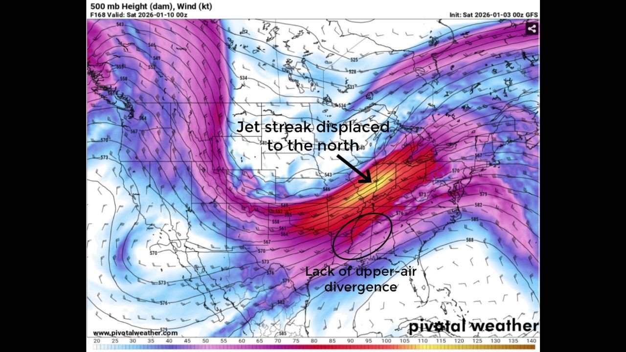
Jet Stream Displacement Limits Upper-Level Support
One of the most important limiting factors in this setup is the position of the jet stream, which remains displaced well north of the primary storm corridor. Forecast guidance shows the strongest upper-level winds and divergence staying removed from the Deep South, preventing robust vertical motion from developing.
Without strong upper-air divergence, storm updrafts struggle to intensify, significantly reducing the chance of organized rotating storms. This configuration favors linear storm modes rather than discrete supercells.
Weak Instability and Poor Lapse Rates Suppress Tornado Potential
Thermodynamic data shows very weak lapse rates and surface-based CAPE generally below 600 J/kg, indicating a lack of buoyant energy needed to support intense thunderstorms. A persistent surface inversion further limits storm strength by capping low-level instability.
These factors combined mean storms will likely be shallow and fast-moving, unable to maintain strong, long-lived rotation.
QLCS Likely, But Only Brief Spin-Ups Possible
The expected storm mode is a stretched-out QLCS (quasi-linear convective system) moving eastward. In Dixie Alley environments, brief tornado spin-ups can occur even in low-instability setups, but current projections suggest these would be isolated, short-lived, and weak.
Sounding data also shows nearly straight-line hodographs, indicating minimal directional shear. While some speed shear is present, parallel shear vectors strongly reduce the likelihood of tornadic circulations.
Primary Impacts Focused on Wind and Heavy Rain
With tornado risk low, the main impacts from this system are expected to include:
- Gusty straight-line winds along the storm line
- Periods of heavy rainfall
- Localized minor power disruptions where winds peak
The absence of meaningful upper-level support and instability keeps the severe threat marginal overall, with no signals currently supporting a significant outbreak scenario.
Forecast Confidence Remains Moderate
While confidence is increasing that this system will stay on the lower end of the severe spectrum, forecasters continue to monitor for any late changes in instability or jet alignment. At this time, however, supercellular storms appear highly unlikely, and the threat remains limited and localized.
Residents across the affected portions of the Southern United States should stay weather-aware but are not expected to face widespread dangerous conditions from this event.
Stay with WaldronNews.com for continued updates as the January 9–10 system approaches and forecast details become clearer.