
Minnesota and Wisconsin Face Another Round of Freezing Rain Along I-94, Creating Dangerous Monday Evening and Night Travel
WISCONSIN — Another round of freezing rain and icy conditions is expected to develop late Monday afternoon through Monday night, with the highest risk concentrated along and north of Interstate 94, according to the latest National Weather Service guidance and regional impact maps.
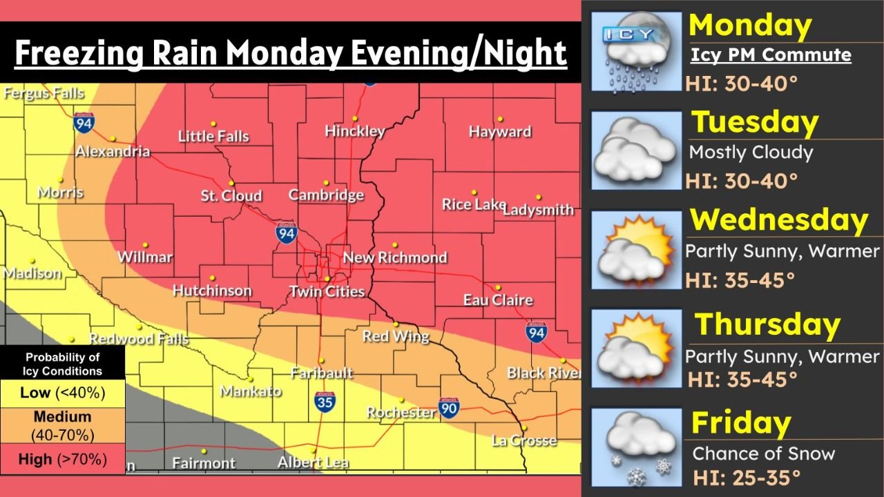
Forecast data shows a high probability (greater than 70%) of icing across a broad portion of central and eastern Minnesota, including the Twin Cities metro, with moderate to high risk extending into western and northwestern Wisconsin. Areas farther south see a lower icing probability, but localized slick spots remain possible.
Highest Ice Risk Focused on Central & Eastern Minnesota
The most concerning conditions are expected across St. Cloud, Cambridge, Hinckley, the Twin Cities, New Richmond, and Eau Claire, where surface temperatures hover near or below freezing while precipitation falls as rain.
Model guidance highlights:
- High icing probability north of I-94
- Moderate risk (40–70%) spreading south toward Hutchinson, Red Wing, and parts of southern Minnesota
- Lower risk (<40%) farther south near Rochester, Albert Lea, and La Crosse, though isolated slick roads are still possible
Even light freezing rain can lead to dangerous travel, especially during peak commute hours.
Monday Evening Commute Expected to Be Especially Hazardous
The Monday evening commute is shaping up to be the most dangerous travel window, as freezing rain intensifies while road temperatures remain cold. Untreated roads, bridges, overpasses, and ramps are expected to become slick very quickly.
Drivers should prepare for:
- Rapid ice accumulation on road surfaces
- Reduced braking effectiveness
- Increased risk of spin-outs and crashes
- Slower traffic and potential delays
Officials urge motorists to slow down, increase following distance, and avoid unnecessary travel during the evening and nighttime hours if possible.
Conditions Improve Midweek Before Another Change Late Week
After the icy start to the week:
- Tuesday: Mostly cloudy with highs in the 30s to near 40
- Wednesday & Thursday: Partly sunny and slightly warmer, highs reaching the mid-30s to mid-40s
- Friday: A cooler shift returns with a chance of snow as temperatures fall back into the mid-20s to mid-30s
While midweek warmth may help improve road conditions, refreezing overnight remains a concern.
What Residents Should Do Now
- Plan ahead for slower travel Monday evening and night
- Check road conditions before heading out
- Carry winter safety supplies in your vehicle
- Allow extra time and avoid sudden braking or sharp turns
Stay with WaldronNews for continued updates on this developing winter weather situation, and let us know how conditions look where you live as the freezing rain moves in.