
Mid-January Pattern Shift Signals Colder Weather Across Illinois, Indiana, Ohio, Michigan, Pennsylvania, New York, and the Eastern U.S.
UNITED STATES — Latest ECMWF, GFS, and CMC ensemble guidance strongly suggests a notable large-scale pattern change developing between January 12 and January 16, with the Eastern United States emerging as the primary impact zone. Multiple long-range signals now align on a deep eastern trough, increasing cold air delivery, and a setup that could support East Coast cyclogenesis, though forecast confidence is still evolving.
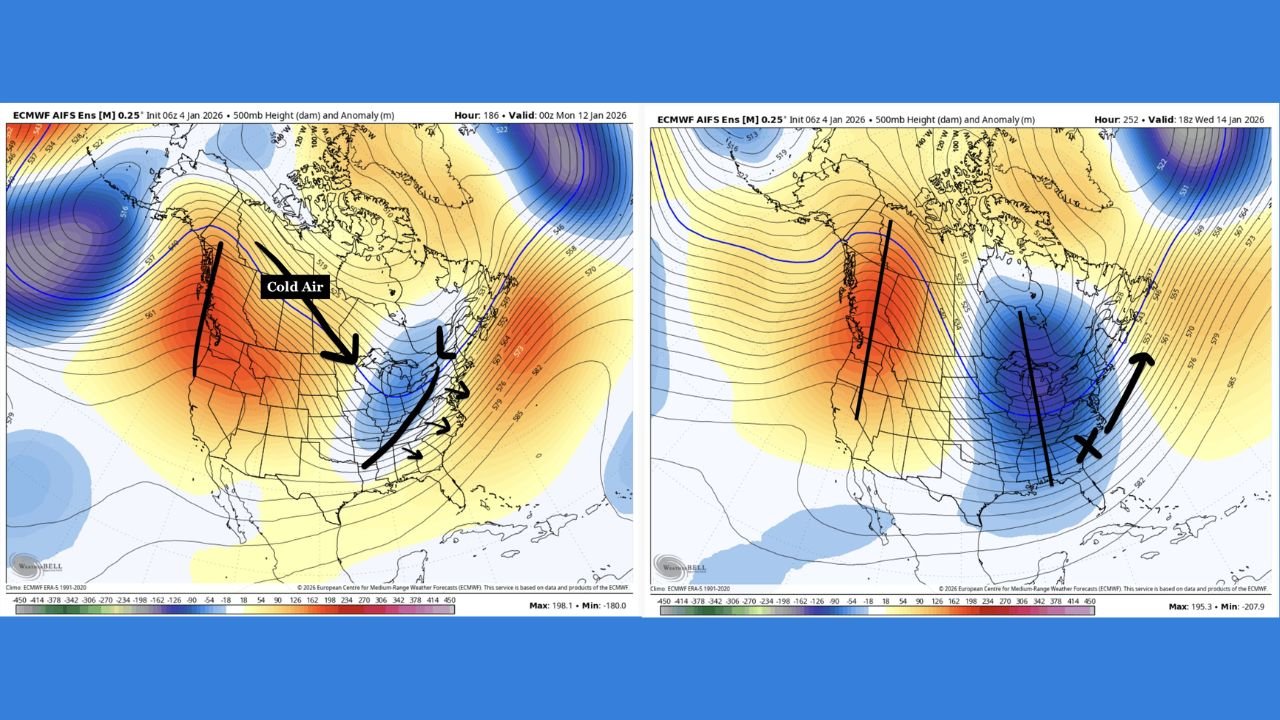
What the Upper-Air Pattern Is Showing
Ensemble height anomalies consistently depict a strengthening +PNA and −EPO configuration, allowing Pacific air to initially flood much of the central U.S. before the pattern flips toward cross-polar flow. This evolution favors colder air masses diving southward into the Midwest, Great Lakes, and Eastern Seaboard after mid-month.
At the same time, NAO trends moving from negative toward neutral or weakly positive reduce blocking near Greenland, increasing the chance that any developing coastal system can organize rather than shear out prematurely.
Coldest Air Targeting the Midwest and East
By January 12–15, ensemble means place a deep trough axis from the Great Lakes through the Ohio Valley and into the Southeast, a classic signal for below-normal temperatures across a large portion of the eastern half of the country.
States most consistently highlighted by cold anomalies include:
- Illinois
- Indiana
- Michigan
- Ohio
- Pennsylvania
- New York
- West Virginia
- Virginia
- Kentucky
- Tennessee
- North Carolina
- Georgia
While this does not currently appear to be an extreme Arctic outbreak, the pattern strongly supports a sustained colder-than-average stretch, especially east of the Mississippi River.
Snow Signal Emerging but Not Locked In
Ensemble snowfall guidance begins to show a recognizable but modest footprint across:
- The Great Lakes
- Interior Northeast
- The central and southern Appalachians
Most current projections suggest light to locally moderate snowfall, generally under 3 inches for many areas, but amounts remain highly sensitive to storm track, timing, and cold air depth.
This is not a high-confidence major winter storm signal yet, but the increasing consistency means it is no longer just noise.
East Coast Storm Potential: Watching the Setup
A favorable trough orientation during this period could allow offshore low-pressure development near the Mid-Atlantic or Northeast coast. However:
- Exact storm placement is uncertain
- Small jet-stream shifts could drastically change impacts
- Confidence will depend on model agreement over the next several days
This remains a monitor-closely scenario, not a guaranteed storm.
Key Things to Watch Next
Over the coming model cycles, forecasters will be watching:
- Whether the southern jet remains active
- How quickly cold air arrives ahead of any system
- If ensemble consistency continues or breaks down
If these signals hold through the end of the week, forecast confidence will increase rapidly.
Bottom Line
The data clearly supports a mid-January pattern shift favoring colder conditions across the Eastern United States, with increasing potential for snow and an East Coast storm system, though details are still being refined. This is a developing setup that warrants close attention over the next several days.
Keep tracking updates closely as newer model runs refine timing, cold intensity, and any storm impacts tied to this evolving mid-January pattern.